WMKK — KL INTERNATIONAL / SEPANG
WMKK AD 2.1 AERODROME LOCATION INDICATOR AND NAME
WMKK — KL INTERNATIONAL / SEPANG
WMKK AD 2.2 AERODROME GEOGRAPHICAL AND ADMINISTRATIVE DATA
| 1 |
ARP coordinates and site at AD |
024436N
1014153E
Site: RWY 14R threshold centerline |
| 2 |
Direction and distance from (city) | Bearing 180° 45' 12"/ 45 KM from Kuala Lumpur Tower, Kuala Lumpur. |
| 3 |
Elevation/Reference temperature | 21 M (69 FT) / 32° C |
| 4 | Geoid undulation at AD ELEV PSN | -2 M |
| 5 |
MAG VAR/Annual change | 0° West (2024) / - 0° 1' 17" W decreasing |
| 6 |
AD operator, address, telephone, telefax, e-mail address, AFS and website address |
Operator: Post:
MALAYSIA AIRPORTS (SEPANG) SDN. BHD. Tel: +603 - 87769999 Fax: +603 - 89265012 URL: www.malaysiaairports.com.my Email: aocaodm@malaysiaairports.com.my ATC Services: Post:
Civil Aviation Authority of Malaysia, Tel: +603 - 87784000 (General Office) Tel: +603 - 87784080 (ATC Tower East) Tel: +603 - 87784183 (ATC Tower West) Tel: +603 - 87784100 Fax: +603 - 87784011 (General Office) Fax: +603 - 87784022 (ATC Tower) Fax: +603 - 87784104 (NOF and ARO) AFS: WMKKZTZX |
| 7 |
Types of traffic permitted (IFR/VFR) |
IFR category: Approved international and domestic flights. VFR category: Approved helicopter operations. |
| 8 |
Remarks |
NIL |
WMKK AD 2.3 OPERATIONAL HOURS
| 1 |
AD Operator |
H 24 | |
| 2 |
Customs and immigration |
H 24 | |
| 3 |
Health and sanitation |
H 24 | |
| 4 |
AIS Briefing Office |
H 24 | |
| 5 |
ATS Reporting Office (ARO) |
H 24 | |
| 6 |
MET Briefing Office |
H 24 | |
| 7 |
ATS |
H 24 | |
| 8 |
Fuelling |
PETRONAS Refuelling SHELL Refuelling PETRON Aviation Refuelling |
:H24 :H24 :H24 |
| 9 |
Handling |
Prior arrangement. | |
| 10 |
Security |
H 24 | |
| 11 |
De-icing |
NIL | |
| 12 |
Remarks |
NIL | |
WMKK AD 2.4 HANDLING SERVICES AND FACILITIES
| 1 |
Cargo-handling facilities |
Cargo terminals equipped with storage stacker, material and pallet container handling systems, animal hotel, computerized cargo information, data and documentation systems. By arrangement with airlines. |
| 2 |
Fuel/oil types |
Jet A1, AVGAS |
| 3 |
Fuelling facilities/capacity |
Hydrant refuelling |
| 4 |
De-icing facilities |
NIL |
| 5 |
Hangar space for visiting aircraft |
(a) Malaysia Airlines Berhad Hangar 5 : (2 x B737 and 2 x B747) (b) Malaysia Airlines Berhad Hangar 6 : (2 x A380) (c) Sepang Aircraft Engineering (SAE) Hangar 01 : (2 x A330 or 4 x A320 or 4 x B737) (d) Sepang Aircraft Engineering (SAE) Hangar 02 : (3 x A320 or 4 x ATR) (e) Asia Digital Engineering (ADE) Hangar A : (2 x A330 or 6 x A320 / A321) (f) Asia Digital Engineering (ADE) Hangar B : (8 x A320/A321) |
| 6 |
Repair facilities for visiting aircraft | Commercial aircraft up to and including Code F Aircraft. |
| 7 |
Remarks |
Handling services available H 24 & by prior arrangement with the aerodrome administration. |
WMKK AD 2.5 PASSENGER FACILITIES
|
1 |
Hotels |
At the airport and in the City. |
|
2 |
Restaurants |
At the airport and in the City. |
|
3 |
Transportation |
Trains, buses, taxis and car for hire from the Airport. |
|
4 |
Medical facilities |
First aid at the Airport. Hospitals in the City |
|
5 |
Bank and Post Office |
At Airport. Open within Airport HR. |
|
6 |
Tourist Office |
At the Terminal Building. |
|
7 |
Remarks |
NIL |
WMKK AD 2.6 RESCUE AND FIRE FIGHTING SERVICES
|
1 |
AD category for fire fighting |
CAT 10 |
|
2 |
Rescue equipment |
Adequately provided as recommended by ICAO. |
|
3 |
Capability for removal of disabled aircraft |
Lifting bags and hydraulic jacks AVBL up to and including B747- 400. |
|
4 |
Remarks |
|
WMKK AD 2.7 SEASONAL AVAILABILITY - CLEARING
|
1 |
Types of clearing equipment |
NIL |
|
2 |
Clearance priorities |
NIL |
|
3 |
Remarks |
NIL |
WMKK AD 2.8 APRONS, TAXIWAYS AND CHECK LOCATIONS/POSITIONS DATA
|
1a |
Apron surface and strength (WI the areas of RWY 14L/32R and 14R/32L) |
C38 Surface : Concrete (Rigid) Strength : PCR 118 / R / C / W / U |
A12 Bay B3 Surface : Concrete (Rigid) Strength : PCR 220 / R / C / W / U |
|
F1L, F1R, F2R, F3L, F3R, F4L, F5L, F5R, F6L, F6R, F7L, F21L, F21R, F22L, F22R, F23L, F23R, F24L, F24R, F25L, F25R, F26L, F26R, F29L, F29R, F30L, F31L, F32L, F33L, F34L Surface : Concrete (Rigid) Strength : PCR 328 / R / C / W / U |
F27 Surface : Concrete (Rigid) Strength : PCR 329 / R / C / W / U | ||
|
A14R, A61 Surface : Concrete (Rigid) Strength : PCR 396 / R / C / W / U |
F4R Surface : Concrete (Rigid) Strength : PCR 417 / R / C / W / U | ||
|
F26 Surface : Concrete (Rigid) Strength : PCR 421 / R / C / W / U |
C28, C81, F34R, M1, M2, M3, M4, M5 Surface : Concrete (Rigid) Strength : PCR 449 / R / C / W / U | ||
|
F7R, F8L, F8R, F30R, F31R, F32R, F33R
Surface : Concrete (Rigid) Strength : PCR 465 / R / C / W / U |
B21, B23 Surface : Concrete (Rigid) Strength : PCR 475 / R / C / W / U | ||
|
C52L, C52R, C13, F9L, F9R, F10L, F10R, F11L, F11R, F28L Surface : Concrete (Rigid) Strength : PCR 486 / R / C / W / U |
A2L, A2R, A4L, A4R, A6L, A6R, A8L, A8R, A10L, A10R, A14L, A51, A51L, A51R, A52R, A53R, A54R, A3, A5, A7, A9, A11, B3, B5, B7, B9, B11, B13, B15, B17, B19, B2L, B2R, B4L, B4R, B6L, B6R, B8L, B8R, B10L, B10R, B12, B14L, B16L, B16R, B51, B51L, B51R, B52, B52L, B52R, B53, B53L, B53R, B54, B54L, B54R, C6, C11, C18, C21, C23, C31, C33, C62, F2L Surface : Concrete (Rigid) Strength : PCR 540 / R / C / W / U | ||
|
F7, F8, F9, F10, F11, F21, F22, F23, F25, F28, F29, F30, F31, F33, F34 Surface : Concrete (Rigid) Strength : PCR 562 / R / C / W / U |
A13, A52, A52L, A53, A53L, A54, A54L, B14R Surface : Concrete (Rigid) Strength : PCR 571 / R / C / W / U | ||
|
C83
Surface : Concrete (Rigid) Strength : PCR 594 / R / C / W / U |
C51, F27L, F27R, F28R
Surface : Concrete (Rigid) Strength : PCR 626 / R / C / W / U | ||
|
C72L, C72R, C73, C73L, C73R, C74L, C74R Surface : Concrete (Rigid) Strength : PCR 660 / R / C / W / U |
F24 Surface : Concrete (Rigid) Strength : PCR 768 / R / C / W / U | ||
|
A14, B6, B8, B10, B14, F1, F2, F3, F4, F5, F6 Surface : Concrete (Rigid) Strength : PCR 789 / R / C / W / U |
A4, A10, B4, B61L, B62, B62L, B62R, B63, B63L, B63R, C1, C4, C12, C12R, C14, C16, C16R, C17, C24, C25, C26, C27, C32, C34, C35, C36, C37, F32 Surface : Concrete (Rigid) Strength : PCR 802 / R / C / W / U | ||
|
A2, A6, A8, B2, B16, C52, C53 Surface : Concrete (Rigid) Strength : PCR 918 / R / C / W / U |
C2, C3, C7, C15, C22, C61 Surface : Concrete (Rigid) Strength : PCR 957 / R / C / W / U | ||
|
C72, C74 Surface : Concrete (Rigid) Strength : PCR 977 / R / C / W / U |
C82, C82L, C82R Surface : Concrete (Rigid) Strength : PCR 1179 / R / C / W / U | ||
|
1b |
Apron surface and strength (WI the areas of RWY 14R/32L and 15/33) |
J1, J3, J5, J7, J9, J11, J13, J15, J17, J2, J4, J6, J8, J10, J12, J14, J16, J18, J20, J22, K1, K3, K5, K7, K9, K11, K13, K22L, K22R, K24, K2, K4, K6, K8, K10, K12, K14, K16, K18, P1, P3, P5, P7, P9, P11, P13, P15, P17, P19, P21, P4L, P4R, P6L, P6R Q1, Q3, Q5, Q7, Q9, Q11, Q13, Q15, Q17, Q19, Q21 Surface : Asphalt (Flexible) Strength : PCR 445 / F / D / X / U |
P8L, P8R, P10L, P10R, P12L, P12R Surface : Asphalt (Flexible) Strength : PCR 651 / F / D / X / U Bay Q16, Q18 Surface : Asphalt (Flexible) Strength : PCR 909 / F / D / X / U |
|
K20, K22, P2, P4, P6, P8, P10, P12, Q2, Q4, Q6, Q8, Q10, Q12, Q14, Q16, Q18 Surface : Asphalt (Flexible) Strength : PCR 805 / F / D / X / U |
Bay P4, P6, P8, P10, P12 Surface : Asphalt (Flexible) Strength : PCR 973 / F / D / X / U | ||
| 2 | Taxiway width, surface and strength |
Taxiway A, B, D, F Apron Taxiway H Taxiway Intersection B5, C9, H3, H5 Width : 25 m Surface : Asphalt (Flexible) Strength : PCR 448 |
Taxiway Intersection A1 Width : 26 m Surface : Concrete (Rigid)Asphalt (Flexible) Strength : PCR 540 |
|
Taxiway C Taxiway Intersection A2, A3, C10, C11 Width : 26 m Surface : Asphalt (Flexible) Strength : PCR 448 / F / C / W / U |
Taxiway Intersection A4, D2, D3, D4, D5, D6, D7, D8, D10, D11, D12 Width : 43 m Surface : Asphalt (Flexible) Strength : PCR 448 | ||
|
Taxiway Intersection A5 Width : 39 m Surface : Asphalt (Flexible) Strength : PCR 448 / F / C / W / U |
Taxiway Intersection A6, B14, C5, D1, F1 - F6 Width : 42 m Surface : Asphalt (Flexible) Strength : PCR 448 / F / C / W / U | ||
|
Taxiway Intersection A7, B7, B13 Width : 44 m Surface : Asphalt (Flexible) Strength : PCR 448 / F / C / W / U |
Taxiway Intersection A8 & Apron Taxiway G Width : 29 m Surface : Asphalt (Flexible) Strength : PCR 448 / F / C / W / U | ||
|
Taxiway Intersection A9 - A11 Width : 28 m Surface : Concrete (Rigid) Strength : PCR 540 / R / C / W / U |
Taxiway Intersection B6, B8 - B12 Width : 44 m Surface : Asphalt (Flexible) Strength : PCR 448 / F / C / W / U | ||
|
Taxiway Intersection C1 Width : 27 m Surface : Concrete (Rigid) Strength : PCR 540 / R / C / W / U |
Taxiway Intersection C2 & E3 Width : 28 m Surface : Concrete (Rigid) Strength : PCR 540 / R / C / W / U | ||
|
Taxiway Intersection C3 & C4 Width : 28 m Surface : Asphalt (Flexible) Strength : PCR 448 / F / C / W / U |
Taxiway Intersection C6 Width : 41 m Surface : Asphalt (Flexible) Strength : PCR 448 / F / C / W / U | ||
|
Taxiway Intersection C7 & C8 Width : 36 m Surface : Asphalt (Flexible) Strength : PCR 448 / F / C / W / U |
Apron Taxiway E, L Taxiway Intersection E, L Width : 24 m Surface : Concrete (Rigid) Strength : PCR 540 / R / C / W / U | ||
|
Taxiway Intersection D13 Width : 32 m Surface : Asphalt (Flexible) Strength : PCR 448 / F / C / W / U |
Taxiway Intersection E1, E2 Width : 39 m Surface : Concrete (Rigid) Asphalt (Flexible) Strength : PCR 540 / R / C / W / U | ||
|
Taxiway Intersection E4 Width : 39 m Surface : Concrete (Rigid)Asphalt (Flexible) Strength : PCR 518 / R / C / W / U |
Taxiway Intersection E5 Width : 24 m Surface : Concrete (Rigid)Asphalt (Flexible) Strength : PCR 518 / R | ||
|
Apron Taxiway K Width : 25 m Surface : Concrete (Rigid)Asphalt (Flexible) Strength : PCR 540 / R / C / W / U |
Apron Taxiway M Width : 25 m Surface : Concrete (Rigid) Strength : PCR 540 / R / C / W / U | ||
|
Taxiway Intersection N1 Width : 50 m Surface : Asphalt (Flexible) Strength : PCR 448 / F / C / W / U |
Taxiway Intersection N2 Width : 35 m Surface : Asphalt (Flexible) Strength : PCR 448 / F / C / W / U | ||
|
Taxiway Intersection P1 & P2 Width : 25 m Surface : Concrete (Rigid) Strength : PCR 518 / R / C / W / U |
Taxiway P (Code C) & Q (Code C) Width : 18 m Surface : Asphalt (Flexible) Strength : PCR 445 / F / D / X / U | ||
|
Apron Taxiway S1 Width : 25 m Surface : Concrete (Rigid)Asphalt (Flexible) Strength : PCR 540 / R / C / W / U |
Apron Taxiway S2 Width : 34 m Surface : Concrete (Rigid)Asphalt (Flexible) Strength : PCR 540 / R / C / W / U | ||
|
Apron Taxiway S3 Width : 23 m Surface : Concrete (Rigid)Asphalt (Flexible) Strength : PCR 540 / R / C / W / U |
Apron Taxiway S4 Width : 36 Surface : Concrete (Rigid)Asphalt (Flexible) Strength : PCR 540 / R / C / W / U | ||
|
Apron Taxiway S5 Width : 23 m Surface : Asphalt (Flexible) Strength : PCR 448 / F / C / W / U |
Apron Taxiway S6, T6 Width : 24 m Surface : Asphalt (Flexible) Strength : PCR 448 / F / C / W / U | ||
|
Apron Taxiway S7 Width : 23 m Surface : Concrete (Rigid)Asphalt (Flexible) Strength : PCR 540 / R / C / W / U |
Apron Taxiway S8 Width : 45 m Surface : Concrete (Rigid)Asphalt (Flexible) Strength : PCR 540 / R / C / W / U | ||
|
Apron Taxiway S9 Width : 26 m Surface : Concrete (Rigid) Strength : PCR 540 / R / C / W / U |
Apron Taxiway S10 Width : 43 Surface : Concrete (Rigid) Strength : PCR 540 / R / C / W / U | ||
|
Aircraft Stand Taxilane T1, T8, T9 Width : 18 m Surface : Concrete (Rigid)Asphalt (Flexible) Strength : PCR 540 / R / C / W / U |
Apron Taxiway T2 & T7 Width : 23 m Surface : Concrete (Rigid)Asphalt (Flexible) Strength : PCR 540 / R / C / W / U | ||
|
Apron Taxiway T3 Width : 29 m Surface : Asphalt (Flexible) Strength : PCR 448 / F / C / W / U |
Apron Taxiway T4 Width : 32 m Surface : Concrete (Rigid)Asphalt (Flexible) Strength : PCR 540 / R / C / W / U | ||
|
Apron Taxiway T5 Width : 30 m Surface : Concrete (Rigid)Asphalt (Flexible) Strength : PCR 540 / R / C / W / U |
Aircraft Stand Taxilane T12 Width : 18 m Surface : Concrete (Rigid) Strength : PCR 540 / R / C / W / U | ||
|
Apron Taxiway T13 Width : 26 m Surface : Concrete (Rigid) Strength : PCR 540 / R / C / W / U |
Apron Taxiway U3 & U4 Width : 18 m Surface : Asphalt (Flexible) Strength : PCR 445 | ||
|
Taxiway U6, Apron Taxiway U5 Width : 25 m Surface : Asphalt (Flexible) Strength : PCR 805 / F / D / X / U |
Aircraft Stand Taxilane U7 Width : 61m Surface : Asphalt (Flexible) Strength : PCR 805 / F / D / X / U | ||
|
Taxiway Intersection Y1 &Y9 Width : 31 m Surface : Concrete (Rigid) Strength : PCR 518 / R / C / W / U |
Taxiway Intersection Y2 & Y8 Width : 35 m Surface : Concrete (Rigid) Strength : PCR 518 / R / C / W / U | ||
|
Taxiway Intersection Y3, Y4, Y5 Width : 35 m Surface : Asphalt (Flexible) Strength : PCR 445 / F / D / X / U |
Taxiway Intersection Y6 & Y7 Width : 34m Surface : Asphalt (Flexible) Strength : PCR 1232445 / F / D / X / U | ||
|
Taxiway Intersection Z1 Width : 33 m Surface : Asphalt (Flexible) Strength : PCR 445 / F / D / X / U |
Taxiway Intersection Z2, Z3, Z4, Z5, Z6, Z7, Z8 Width : 40 m Surface : Asphalt (Flexible) Strength : PCR 445 / F / D / X / U | ||
|
Taxiway Intersection P3, P4, Q5, Q6, Q7, Taxiway Y & Taxiway Z Width : 25 m Surface : Asphalt (Flexible) Strength : PCR 445 / F / D / X / U | |||
|
3 |
Altimeter checkpoint location and elevation | Location | Elevation |
| KLIA Terminal 1 (T1) | 21 m 21 M | ||
| KLIA Terminal 2 (T2) | 10 m 10 M | ||
|
4 |
VOR checkpoints |
NIL | |
| 5 |
INS checkpoints |
At aircraft parking stands (See AD 2-WMKK-2-7 until AD 2-WMKK-2-14 | |
| 6 |
Remarks |
| |
WMKK AD 2.9 SURFACE MOVEMENT GUIDANCE AND CONTROL SYSTEM AND MARKINGS
| 1 |
Use of aircraft stand ID signs, TWY guide lines and visual docking/parking guidance system of aircraft stands |
Taxiing guidance signs at all intersections with TWY and RWY and at all holding positions. Guide lines at apron. Nose - in guidance at aircraft stands. |
| 2 |
RWY and TWY markings and LGT |
RWY: Designation, threshold, side stripe, transverse stripe, touchdown zone, aiming point and centre line markings. Chevron markings at RWY 14L, 32L, RWY 15 and RWY LGT: Edge, threshold, end, touchdown zone, centre line and wing bar lights. TWY: Centre line, taxi side stripe, transverse stripe, TWY LGT: Centre line, intermediate holding position, exit and edge lights. |
| 3 |
Stop bars and runway guard lights (if any) |
Stop bars on all RWY / TWY intersections. (WI the areas of RWY 14L/32R and 14R/32L) Stop bars on all RWY / TWY intersections and Supplementary Stop bars provided at TWY Q5, Q6 and Q7 located 250 M from RWY 14RCentre line. (WI the areas of RWY 14R/32L and 15/33) Runway guard lights on all RWY/TWY intersections. |
| 4 |
Remarks |
This to ensure unobstructed access from the Fire Station for emergency vehicles, such as fire trucks and rescue teams during emergencies |
WMKK AD 2.10 AERODROME OBSTACLES
|
In approach/TKOF areas |
In circling area and at AD |
Remarks | |||
|---|---|---|---|---|---|
| 1 | 2 | 3 | |||
|
RWY NR/Area affected |
Obstacle type Elevation Markings/LGT |
Coordinates |
Obstacle type Elevation Markings/LGT |
Coordinates | |
| a | b | c | a | b | |
|
14R/APCH 32L/TKOF |
LOC ANTENNAS: 19.83 M Red/Red obstruction lights |
024443.7N
1014147.4E
|
GP AERIAL 27.8 M Red/white Red obstruction lights |
024425.6N
1014154.8E
|
NIL |
|
TELECOMMUNICATION TOWER 1 : 202.76 FT AMSL Marked and lighted |
024552.1N
1014151.9E
|
WDI 23 M Marked and lighted |
024432.1N
1014158.9E
| ||
|
TELECOMMUNICATION TOWER 2 : 202.76 FT AMSL Marked and lighted |
024550.0N
1014151.2E
| ||||
|
32L/APCH 14R/TKOF |
LOC ANTENNAS 15.46 M Red/Red obstruction lights |
024241.22N
1014309.48E
|
GP AERIAL 26.63 M Red/white Red obstruction lights |
024253.83N
1014256.54E
|
NIL |
|
AWOS NO.7 22.3 M |
024254.7N
1014255.5E
|
WDI 21.0 M Marked and lighted |
024255.8N
1014255.7E
| ||
| AWOS NO.8 22.1 M |
024339.7N
1014225.6E
|
HILL - BUKIT LADA 110.048M AMSL Red obstruction lights |
024232.7N
1014356.6E
| ||
| AWOS NO.9 23.5 M |
024424.2N
1014155.8E
|
HILL - BUKIT SUNGAI LANAU 100.890 M AMSL Red obstruction lights |
024158.1N
1014304.7E
| ||
|
POWER PLANT - 15KM South of THR RWY 32 525FT AMSL Marked and lighted at night. |
023524.6N
1014327.9E
| ||||
|
14L/APCH 32R/TKOF |
LOC ANTENNAS 19.23 M Red/Red obstruction lights |
024648.7N
1014202.5E
|
GP AERIAL 29.60 M Red/white Red obstruction lights |
024636.6N
1014215.3E
|
NIL |
| AWOS NO.2 24.9 M |
024635.0N
1014216.4E
|
WDI 24 M Marked and lighted |
024634.9N
1014215.7E
| ||
| AWOS NO.3 25.3 M |
024550.5N
1014245.7E
|
CONTROL TOWER 141.45 M Red obstruction lights |
024525.5N
1014208.8E
| ||
| AWOS NO.4 27.6 M |
024506.0N
1014316.1E
|
RADAR SENSOR 69.8 M Red obstruction lights |
024630.0N
1014124.0E
| ||
|
TELECOMMUNICATION TOWER 1: 202.76 FT AMSL Marked and lighted |
024552.1N
1014151.9E
| ||||
|
TELECOMMUNICATION TOWER 2 : 202.76 FT AMSL Marked and lighted |
024550.0N
1014151.2E
| ||||
|
32R/APCH 14L/TKOF |
LOC ANTENNAS 25.02 M Red/Red obstruction lights |
024445.0N
1014325.3E
|
GP AERIAL 33.21 M Red/white Red obstruction light |
024504.87N
1014316.8E
|
NIL |
|
WDI 27 M Marked and lighted |
024457.5N
1014313.0E
| ||||
| TELECOMMUNICATION TOWER 182.88 M AMSL |
024826.19N
1014440.41E
| ||||
| 15/APCH 33/TKOF | LOC ANTENNAS 11.7 M |
024411.0N
1014021.7E
|
GP AERIAL 23.7M Red/White Red obstruction light |
024408.0N
1014042.1E
| Western side of RWY 15/33 and behind the two GP aerials line. |
|
WDI 16 M Marked and lighted |
024414.5N
1014045.1E
| ||||
| AWOS NO.13 11.2 M |
024408.1N
1014135.8E
| KLIA CONTROL TOWER WEST 146.9M AMSL. Red obstruction lights |
024445.7N
1014105.0E
| ||
| AWOS No. 14 11.2 M |
024407.8N
1014041.5E | Multilateration Surveillance System (MSS) Sensors Antennas: | |||
| AWOS NO.15 11.2 M |
024413.7N
1014021.0E
| GS45 - 23.7 M |
024407.5N
1014041.1E
| ||
| GS46 - 18.7M |
024328.5N
1014106.3E
| ||||
| GS47 - 18.7M |
024258.6N
1014126.5E
| ||||
| GS48 - 18.7M |
024224.1N
1014148.5E
| ||||
| 33/APCH 15/TKOF | LOC ANTENNAS 11.7 M |
024411.0N
1014250.1E
| GP AERIAL 23.7M Red/White Red obstruction lights |
024237.2N
1014143.0E
| NIL |
| AWOS NO.11 11.2 M |
024413.7N
1014250.6E
|
WDI 16 M Marked and lighted |
024238.4N
1014141.3E
| ||
| AWOS NO.12 11.2 M |
024407.79N
1014230.18E
|
HILL - BUKIT LADA 110.0M AMSL Red obstruction lights |
024232.7N
1014356.6E
| ||
|
HILL - BUKIT SUNGAI LANAU 100.9M MSL Red obstruction lights |
024158.1N
1014304.7E
| ||||
WMKK AD 2.11 METEOROLOGICAL INFORMATION PROVIDED
| 1 |
Associated MET Office |
AMO KLIA |
| 2 |
Hours of service MET Office outside hours |
H 24 |
| 3 |
Office responsible for TAF preparation Periods of validity |
AMO KLIA 30HR (0006 0612 1218 1824) |
| 4 |
Trend forecast Interval of issuance |
TREND |
| 5 |
Briefing/consultation provided |
Provided |
| 6 |
Flight documentation Language(s) used |
Charts, Tabular Form and Abbreviated Plain Language Text English |
| 7 |
Charts and other information available for briefing or consultation |
Flight Level Wind/Temp FL050, FL100, FL140, FL180, FL240, FL270, FL300, FL320, FL340, FL360, FL390, FL410, FL450 and FL530, SIGWX, Volcanic Ash/Tropical Cyclone Advisory Bulletin, SIGMET, AIRMET, Aerodrome Warning, Wind Shear Warning, METAR Bulletin, TAFOR Bulletin, WMKK Take-Off Data, Area QNH for Kuala Lumpur FIR and Kota Kinabalu FIR, Radar and Satellite Pictures. |
| 8 |
Supplementary equipment available for providing information |
Doppler Weather Radar and Aviation Self-Briefing Terminal - ABT (Internet) |
| 9 |
ATS units provided with information |
KLIA APP/TWR, Subang ACC/RCC |
| 10 |
Additional information (limitation of service, etc.) |
Tel: +603 - 87872388 Fax: +603 - 87871020 / +603 - 87871019 |
WMKK AD 2.12 RUNWAY PHYSICAL CHARACTERISTICS
|
Designations RWY NR |
TRUE BRG |
Dimensions of RWY(M) | Strength (PCR) and surface of RWY and SWY |
THR coordinates RWY end coordinates THR geoid undulation | THR elevation and highest elevation of TDZ of precision APP RWY |
|---|---|---|---|---|---|
| 1 | 2 | 3 | 4 | 5 | 6 |
|
14R |
146.01° | 4000 x 60 |
PCR 540 / R / C / W / U - 241 m PCR 448 PCR 540 |
THR coordinates
024435.84N
1014152.63E
RWY end coordinates
024247.86N
1014305.03E
THR geoid undulation
-1.5 m |
THR:16.5 m TDZ:16.5 m |
| 32L |
326.01° | 4000 x 60 |
PCR 540 PCR 448 PCR 1179540 / R / C / W / U - 241 m |
THR coordinates
024247.86N
1014305.03E
RWY end coordinates
024435.84N
1014152.63E
THR geoid undulation
-1.4 m |
THR:14.5 m TDZ:14.5 m |
|
14L |
146.01° |
4019 x 60 |
PCR 540 / R / C / W / U - 241 m Concrete PCR 448 / F / C / W / U - 3537 m Asphalt PCR 540 / R / C / W / U - 241m Concrete |
THR coordinates
024642.52N
1014206.67E
RWY end coordinates
024454.03N
1014319.41E
THR geoid undulation -1.5 m |
THR:16.6 m TDZ:16.6 m |
|
32R |
326.01° |
4019 x 60 |
PCR 540 / R / C / W / U - 241m Concrete PCR 448 / F / C / W / U -3537 m Asphalt PCR 540 / R / C / W / U - 241 m Concrete |
THR coordinates
024454.03N
1014319.41E
RWY end coordinates
024642.52N
1014206.67E
THR geoid undulation -1.4 m |
THR:21.2 m TDZ:21.2 m |
|
15 |
146.01° |
3960 x 60 |
PCR 518 / R / C / W / U - 550 m Concrete PCR 427 / F / C / W / U - 3410 m Asphalt |
THR coordinates
024417.57N
1014038.97E
RWY end coordinates
024230.67N
1014150.65E
THR geoid undulation -1.6 m |
THR:8.4 m TDZ:8.4 m |
|
33 |
326.01° |
3960 x 60 |
PCR 427 / F / C / W / U - 3410 m Asphalt PCR 518 / R / C / W / U - 550 m Concrete |
THR coordinates
024230.67N
1014150.65E
RWY end coordinates
024417.57N
1014038.97E
THR geoid undulation -1.5 m |
THR:8.3 m TDZ:8.3 m |
| Slope of RWY-RESA |
SWY dimensions (M) | CWY dimensions (M) | Strip dimensions (M) | OFZ | Remarks | ||
|---|---|---|---|---|---|---|---|
| 7 | 8 | 9 | 10 | 11 | 12 | ||
|
0.05% |
NIL |
NIL |
4120 x 300 |
Provided |
RESA RWY 14R: 120 m x 120 mM | ||
|
0.05% |
NIL |
NIL |
4120 x 300 |
Provided |
RESA RWY 32L: 176 m x 120 mM | ||
|
0.11% 0.12% |
NIL |
NIL |
4139 x 300 |
Provided |
RESA RWY 14L: 225 m x 120 mM | ||
|
0.11% 0.12% |
NIL |
NIL |
4139 x 300 |
Provided |
RESA RWY 32R: 120 m x 120 mM | ||
|
0.004% 0.00% |
NIL |
NIL |
4080 x 300 | Provided |
RESA RWY 15: 240 m X 120 m | ||
|
0.004% 0.00% |
NIL |
NIL |
4080 x 300 |
Provided |
RESA RWY 33: 200 m X 120 m | ||
WMKK AD 2.13 DECLARED DISTANCES
|
RWY designator |
FROM |
TORA (M) |
TODA (M) |
ASDA (M) |
LDA (M) |
Remarks |
|---|---|---|---|---|---|---|
|
1 |
2 |
3 |
4 |
5 |
6 |
7 |
|
14L |
THRESHOLD |
4019 |
4019 |
4019 |
4019 |
NIL |
|
TWY A2 |
3604 |
3604 |
3604 |
NIL |
NIL | |
|
TWY A3 |
2832 |
2832 |
2832 |
NIL |
NIL | |
|
TWY A4 |
2520 |
2520 |
2520 |
NIL |
NIL | |
|
TWY A5 |
2070 |
2070 |
2070 |
NIL |
NIL | |
|
32R |
THRESHOLD |
4019 |
4019 |
4019 |
4019 |
NIL |
|
TWY A10 |
3954 |
3954 |
3954 |
NIL |
NIL | |
|
TWY A9 |
3634 |
3634 |
3634 |
NIL |
NIL | |
|
TWY A8 |
2887 |
2887 |
2887 |
NIL |
NIL | |
|
TWY A7 |
2574 |
2574 |
2574 |
NIL |
NIL | |
|
TWY A6 |
2065 |
2065 |
2065 |
NIL |
NIL | |
|
14R |
THRESHOLD | 4000 | 4000 | 4000 | 4000 |
NIL |
|
TWY C2 |
3887 |
3887 |
3887 |
NIL |
NIL | |
|
TWY P2 |
3839 |
3839 |
3839 |
NIL |
NIL | |
|
TWY C3 |
3566 |
3566 |
3566 |
NIL |
NIL | |
|
TWY P3 |
3519 |
3519 |
3519 |
NIL |
NIL | |
|
TWY P4 |
3030 |
3030 |
3030 |
NIL |
NIL | |
|
TWY C4 |
2820 |
2820 |
2820 |
NIL |
NIL | |
|
TWY C5 |
2507 |
2507 |
2507 |
NIL |
NIL | |
|
TWY C6 |
2050 |
2050 |
2050 |
NIL |
NIL | |
|
32L |
THRESHOLD |
4000 |
4000 |
4000 |
4000 |
NIL |
|
TWY C10 |
3585 |
3585 |
3585 |
NIL |
NIL | |
|
TWY C9 |
2812 |
2812 |
2812 |
NIL |
NIL | |
|
TWY C8 |
2500 |
2500 |
2500 |
NIL |
NIL | |
|
TWY C7 |
2048 |
2048 |
2048 |
NIL |
NIL | |
|
15 |
THRESHOLD | 3960 |
3960 | 3960 |
3960 |
NIL |
|
TWY Y2 | 3505 | 3505 | 3505 |
NIL |
NIL | |
|
TWY Y3 |
3400 |
3400 |
3400 |
NIL |
NIL | |
|
TWY Y4 |
2630 |
2630 |
2630 |
NIL |
NIL | |
|
TWY Y5 |
2180 |
2180 |
2180 |
NIL |
NIL | |
|
33 |
THRESHOLD |
3960 | 3960 | 3960 | 3960 |
NIL |
|
TWY Y8 |
3827 |
3827 |
3827 |
NIL |
NIL | |
|
TWY Y7 |
2632 |
2632 |
2632 |
NIL |
NIL | |
|
TWY Y6 |
2182 |
2182 |
2182 |
NIL |
NIL |
WMKK AD 2.14 APPROACH AND RUNWAY LIGHTING
|
RWY Designator |
APCH LGT type LEN INTST |
THR LGT colour WBAR |
VASIS (MEHT) PAPI |
TDZ, LGT LEN |
RWY Centre Line LGT Length, spacing, colour, INTST |
RWY edge LGT LEN, spacing, colour INTST |
RWY End LGT colour WBAR |
SWY LGT LEN (M) colour |
Remarks |
|---|---|---|---|---|---|---|---|---|---|
| 1 | 2 | 3 | 4 | 5 | 6 | 7 | 8 | 9 | 10 |
| 14L |
CAT I 900 M LIH Capacitor Discharge Lights from 900M to 300M | Green Green |
PAPI LEFT/RIGHT 3° (19.5 M)64.0 FT | 900 M |
4019 M, 15 M,
Variable White:
Red/Variable White:
Red: LIH |
4019 M, 60 M,
Variable White:
Yellow: LIH | Red |
NIL |
NIL |
| 32R |
CAT I 900 M LIH Capacitor Discharge Lights from 900M to 300M | Green Green |
PAPI LEFT/RIGHT 3° (19.3 M)63.3FT | 900 M |
4019 M, 15 M,
Variable White:
Red/Variable White:
Red: LIH |
4019 M, 60 M,
Variable White:
Yellow: LIH | Red |
NIL |
NIL |
| 14R |
CAT I 900 M LIH Capacitor Discharge Lights from 900M to 300M |
Green - |
PAPI LEFT 3° (20.2 M)66.3FT | 900 M |
4000 M, 15 M,
Variable White:
Red/Variable White:
Red: LIH |
4000 M, 60 M,
Variable White:
Yellow: LIH | Red |
NIL |
NIL |
| 32L |
CAT I 900 M LIH Capacitor Discharge Lights from 900M to 300M | Green Green |
PAPI LEFT/RIGHT 3° (18.8 M)61.7FT | 900 M |
4000 M, 15 M,
Variable White:
Red/Variable White:
Red: LIH |
4000 M, 60 M,
Variable White:
Yellow: LIH | Red |
NIL |
NIL |
| 15 |
CAT I 900 M LIH |
Green - |
PAPI RIGHT 3°
(19.0 M) |
NIL |
3960 M, 15 M,
Variable White:
Red/Variable White:
Red: LIH |
3960 M, 60 M,
Variable White:
Yellow: LIH | Red |
NIL |
NIL |
| 33 |
CAT I 900 M LIH |
Green - |
PAPI LEFT 3° (19.0 M)62.3FT |
NIL |
3960 M, 15 M,
Variable White:
Red/Variable White:
Red: LIH |
3960 M, 60 M,
Variable White:
Yellow: LIH | Red |
NIL |
NIL |
WMKK AD 2.15 OTHER LIGHTING, SECONDARY POWER SUPPLY
| 1 |
ABN/IBN location, characteristics and operational hours |
NIL |
| 2 |
LDI location and LGT Anemometer location and LGT |
LDI: NIL Illuminated Wind Direction Indicator (Illuminated WDI). RWY 14L : 348 M from THR on left side, 101 M from RWY centre line and lighted. RWY 32R : 202 M from THR on left side, 101 M from RWY centre line and lighted. RWY 14R : 198 M from THR on left side, 100 M from RWY centre line and lighted. RWY 32L : 371 M from THR on left side, 101 M from RWY centre line and lighted. RWY 15 : 185 M from THR on left side, 105 M from RWY centre line and lighted. RWY 33 : 368 M from THR on left side, 106 M from RWY centre line and lighted. |
| 3 |
TWY edge and centre line lighting |
Edge: At all TWY curves and fillets Centre Line: At all TWY. |
| 4 |
Secondary power supply/switch-over time |
Secondary power supply to all lightings. RWY 1 = RWY 14L/32R RWY 2 = RWY 14R/32L Switch over time: 1 sec - Inner 300 M of the approach lighting system, runway edge, runway threshold, runway end, runway centre line, runway touchdown zone, all stop bars. 15 sec - Essential taxiway, other parts of the approach lighting system, obstacle, visual approach slope indicators. RWY 3 = RWY 15/33 Switch over time: 15 sec - Approach Lighting System, Runway Edge, Runway Threshold, Runway End, Essential Taxiway, Obstacles and Visual Approach Slope Indicators. |
| 5 |
Remarks |
Intermediate Holding Position Light: At all TWY intersections. |
WMKK AD 2.16 HELICOPTER LANDING AREA
| 1 |
Coordinates TLOF or THR of FATO Geoid undulation | 024550.68N 1014204.20E |
| 2 |
TLOF and/or FATO elevation M/FT |
22.10M/72.51FT. |
| 3 |
TLOF and FATO area dimensions, surface, strength, marking |
Rectangle, 30M x 30M, Asphalt, 30 Tonnes White edges and white letter H |
| 4 |
True BRG of FATO |
True North Bearing - 61 45 00 from ARG X-axis Magnetic Bearing - 10.69 min West of True North. |
| 5 |
Declared distance available |
NIL |
| 6 |
APP and FATO lighting |
NIL |
| 7 |
KLIA Emergency Response Helicopter Landing Zones (restricted use) |
Refer to WMKK AD 2.24 |
| 8 |
Remarks |
Ground taxi to apron |
WMKK AD 2.17 ATS AIRSPACE
| 1 |
Designation and lateral limits |
KUALA LUMPUR CTR Semi circle of 15NM radius centred on Kuala Lumpur (VKL) DVOR/DME (024328N 1014417E) fm 024450N 1015913E clockwise to 023709N 1013041E then a straight line to 030134N 1011921E then a semicircle of 15NM radius centred on SAAS Subang ARP (030752N 1013253E) clockwise to 032245N 1013454E then a straight line to 032133N 1014406E then a semi circle of 15NM radius centred on Simpang ARP (030641N 1014209E) clockwise to 030803N 1015706E then a straight line to 024450N 1015913E. |
| 2 |
Vertical limits |
SFC to 3 500 FT AMSL |
| 3 |
Airspace classification |
Class C (except for WMR 418/236 which is G) |
| 4 |
ATS unit call sign Language(s) |
Lumpur Departure, Lumpur Radar. Lumpur Tower. English |
| 5 |
Transition altitude | 11 000 FT AMSL |
| 6 |
Remarks |
NIL |
WMKK AD 2.18 ATS COMMUNICATION FACILITIES
|
Service designation |
Call sign |
Frequency |
Hours of operation |
Remarks |
|---|---|---|---|---|
| 1 | 2 | 3 | 4 | 5 |
| APP | LUMPUR RADAR |
118.650 MHZ 121.250 MHZ 124.200 MHZ 125.850 MHZ | H 24 | - |
| APP | LUMPUR RADAR |
119.450 MHZ 120.350 MHZ 124.650 MHZ 125.100 MHZ 135.750 MHZ | - | |
| APP | LUMPUR DEPARTURE | 135.250 MHZ | - | |
| AERODROME CONTROL | LUMPUR TOWER |
118.800 MHZ | RWY 14L/32R | |
| AERODROME CONTROL | LUMPUR TOWER |
118.500 MHZ | RWY 14R/32L | |
| AERODROME CONTROL | LUMPUR TOWER | 119.800 MHZ | RWY 15/33 | |
| SURFACE MOVEMENT CONTROL | LUMPUR GROUND |
121.650 MHZ |
TWY A including taxiways A1 to A11 | |
| SURFACE MOVEMENT CONTROL | LUMPUR GROUND |
121.800 MHZ |
TWY C including taxiways C1 to C11 | |
| SURFACE MOVEMENT CONTROL | LUMPUR GROUND |
122.525 MHZ |
TWY P including taxiways P1 to P4 | |
| SURFACE MOVEMENT CONTROL | LUMPUR GROUND |
118.050 MHZ |
TWY Y including taxiways Y1 to Y9 | |
| SURFACE MOVEMENT CONTROL | LUMPUR GROUND | 122.150 MHZ |
TWY T1, T2, T3, T4, T5, T8, T9 and T12 TWY T6 between taxiways T7 and T9 TWY T7 between taxiways T5 and T6 | |
| SURFACE MOVEMENT CONTROL | LUMPUR GROUND |
122.850 MHZ | H 24 |
TWY F between taxiways B and F6 |
| SURFACE MOVEMENT CONTROL | LUMPUR GROUND |
122.275 MHZ |
TWY H | |
| SURFACE MOVEMENT CONTROL | LUMPUR GROUND |
123.250 MHZ |
TWY A between A11 and B14 | |
| SURFACE MOVEMENT CONTROL | LUMPUR GROUND |
121.725 MHZ |
TAXILANE U1, U2, U7, U8 and U9 | |
| SURFACE MOVEMENT CONTROL | LUMPUR GROUND |
122.550 MHZ |
TWY U3 including taxiways U3A to U3F | |
| SURFACE MOVEMENT GROUND | LUMPUR GROUND |
130.75 MHZ |
TWY U5 including taxiways U5A to U5D TWY U6 | |
| ACD | LUMPUR DELIVERY |
126.000 MHZ |
Airways clearance, SSR Code allocation and departure slot time for: | |
| ACD | LUMPUR DELIVERY | 128.150 MHZ |
Airways clearance, SSR Code allocation and departure slot time for: i. All domestic flight within Peninsular Malaysia. ii. Flight to Subang (WMSA) and Training Area. iii. Flight to a destination beyond WMKK FIR via the following ATS Routes and Exit Waypoints: - Y501 (RIGTO) - Y502 (DUBAX) - A457 (TAMOS) - R461 (PUGER) - N633 (SALAX) - P628 (IGREX) - L510 (EMRAN) - N571 (IGOGU) - P574 (NOPEK) - B466 (ANOKO) | |
| D-ATIS | LUMPUR TERMINAL INFORMATION |
126.450 MHZ |
H24 |
Departure D-ATIS
Departure ATIS. Data-link ATIS (D-ATIS) available via WMKK & synthesized voice broadcast |
|
D-ATIS | LUMPUR TERMINAL INFORMATION |
128.050 MHZ |
Arrival D-ATIS Data-link ATIS (D-ATIS) available via WMKK & synthesized voice broadcast |
WMKK AD 2.19 RADIO NAVIGATION AND LANDING AIDS
|
Type of aid, MAG VAR, CAT of ILS/MLS (For VOR/ILS/MLS, give declination) |
ID |
Frequency | Hours of operation |
Position of transmitting antenna coordinates |
Elevation of DME transmitting antenna |
Remarks |
|---|---|---|---|---|---|---|
| 1 | 2 | 3 | 4 | 5 | 6 | 7 |
| DVOR / DME | VKL |
116.100 MHZ CH 108X | H24 |
024328N
1014417E
| 90 M |
NIL |
|
SEPANG DVOR / DME |
VSP |
114.40 MHZ (CH 91X) |
024507.71N 1014005.72E | 3.86 M |
NIL | |
|
TANJUNG SEPAT DME |
DTS | CH 84X | 023944.60N 1013333.60E |
3.00 M |
NIL | |
| ILS/DME CAT I | IEL |
108.500 MHZ CH 22X |
GP/DME: 024636.6N
1014215.3E
LOC: 024444.99N
1014325.57E
|
19.8 M |
14L | |
| ILS/DME CAT I | IER |
109.100 MHZ CH 28X |
GP/DME: 024504.9N
1014316.8E
LOC: 024648.7N
1014202.5E
|
23.41 M |
32R | |
| ILS/DME CAT I | IWR |
110.700 MHZ CH 44X |
GP/DME: 024425.6N
1014154.8E
LOC: 024241.7N
1014309.2E
|
24 M |
14R | |
| ILS/DME CAT I | IWL |
111.900 MHZ CH 56X |
GP/DME: 024254.0N
1014256.7E
LOC: 024443.6N
1014147.4E
|
25 M |
32L | |
| ILS/DME CAT I | IWK |
110.100 MHZ CH 38X |
GP/DME: 024407.4N
1014041.4E
LOC: 024222.2N
1014156.3E
|
24 M |
15 | |
| ILS/DME CAT I | IWM |
111.500 MHZ CH 52X |
GP/DME: 024236.7N
1014142.2E
LOC: 024425.3N
1014033.2E
|
22 M |
33 |
WMKK AD 2.20 LOCAL TRAFFIC REGULATIONS
2.20.1 Aircraft Start Up And / Or Push Back
2.20.2 Taxiing Routes - Departure And Arrival
RFFS 1: TWY B BTN INT B5 and INT B6
RFFS 2: TWY D BTN INT E2 and INT D10
RFFS 3: TWY Z in front of FIRE STATION 3
This is to ensure unobstructed access from the RFFS Station for emergency vehicles such as fire trucks and rescue teams during emergencies.
2.20.3 Intersection Departures
2.20.4 Departure Regulation
2.20.5 MULTILATERATION SURVEILLANCE SYSTEM (MSS)
2.20.5.2 FLIGHT CREW REQUIREMENTS
2.20.6 Crossing an unserviceable Stop Bar
Issue a instruction to the pilot to cross the lit stop bar."Stop bar unserviceable, cross red stop bar, line up runway (designator)”, or
Use a Follow-Me Vehicle to guide the aircraft through the lit stop bar.
2.20.7 Aircraft Stand Allocation
2.20.8 Helicopter Operations
as below:
a) Mantin (024929N 1015325E) - 1000FT - Track 250°/070° - Salak (024625N 1014444E) - KLIA
b) Semenyih (025659N 1015035E) - 1000FT - Track 210°/030° - Salak (024625N 1014444E) - KLIA
Hours of operation: HJ
Note:
-
These access routes are restricted to helicopter traffic having landing rights at KLIA.
-
Clearance limit inbound: Salak
2.20.9 Procedures For Towing of Aircraft.
2.20.10 Jet Blast Procedures
| Aircraft Stand | Standard Pushback Procedures | Non Standard Pushback Procedures |
|---|---|---|
A3 and A5 B3 and B5 | Aircraft to be pushed back and towed forward to breakaway point 100 metres from blast fence before taxiing out. Engine start at the bay is prohibited. Engine start is only permitted at breakway point. | |
| A2, A2L,A2R, A4, A4L and A4R | Aircraft to be pushed back and towed forward to breakaway point abeam aircraft stand A6 before taxiing out. | |
| B2, B2L, B2R, B4, B4L and B4R | Aircraft to be pushed back and towed forward to breakaway point abeam aircraft stand B6 before taxiing out. | |
| C2, C4, C6, C13 and C15 | Wide body aircraft at aircraft stand C6 to be pushed back and towed forward to breakaway point abeam aircraft stand C4 before taxiing out. Wide body aircraft at aircraft stand C13 to be pushed back and towed forward to breakaway point abeam aircraft stand C15 before taxiing out. | Wide body aircraft at aircraft stand C2 and C4 to be pushed back and towed forward to breakaway point abeam aircraft stand C6 before taxiing out. |
| C3, C7, C7L, C7R, C34 and C36 | Wide body aircraft at aircraft stand C34 and C36 to be pushed back and towed forward to breakaway point abeam aircraft stand C36 before taxiing out. | Wide body aircraft at aircraft stand C3 and C7 to be pushed back and towed forward to breakaway point abeam aircraft stand C7 before taxiing out. |
| C14, C16, C16R, C23 and C25 | Wide body aircraft at aircraft stand C23 and C25 to be pushed back and towed forward to breakaway point abeam aircraft stand C25 before taxiing out. | Wide body aircraft at aircraft stand C14 and C16 to be pushed back and towed forward to breakaway point abeam aircraft stand C16 before taxiing out. |
| C24, C26, C33 and C35 | Wide body aircraft at aircraft stand C33 and C35 to be pushed back and towed forward to breakaway point abeam aircraft stand C35 before taxiing out. | Wide body aircraft at aircraft stand C24 and C26 to be pushed back and towed forward to breakaway point abeam aircraft stand C26 before taxiing out. |
| Cargo Stand | All wide body aircraft at cargo stand are to be pushed back and aligned on taxiway centreline before taxiing out. | Aircraft from aircraft stand F34 to push back and tow forward till abeam aircraft stand F32 before starting up as to avoid jet blast effect to the vehicle at the adjacent service road. |
Aircraft have to tow in to aircraft stand B3 in the event of VDGS unserviceable to avoid aircraft jet blast during breakaway on aircraft stand taxilane.
2.20.11 VISUAL DOCKING GUIDANCE SYSTEMS PROCEDURES KLIA TERMINAL 1 (T1)
C12R and C16R
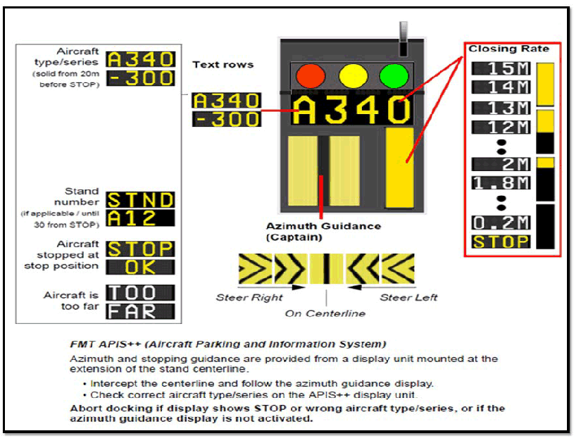
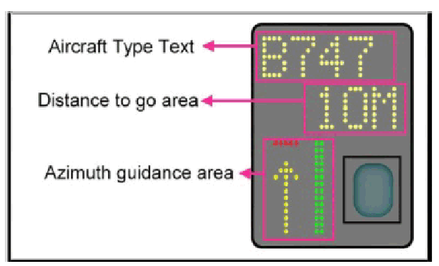
Azimuth Guidance and Stop Information provided from a Display Unit mounted in the extension of the stand center line in front of the cockpit. The Azimuth Guidance is aligned for the pilot occupying the left seat.
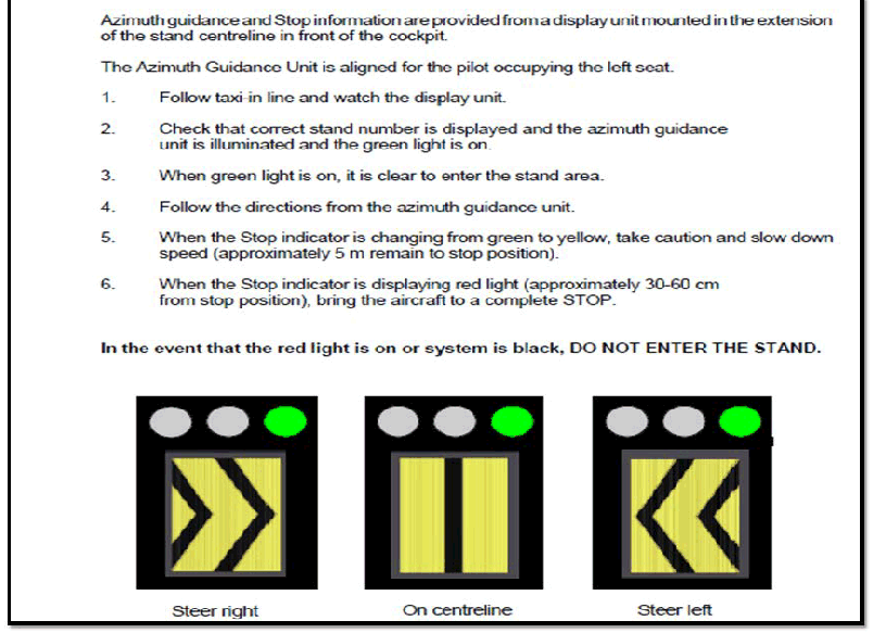
A2, A2R, A2L, B2, B2R, B2L, B4, B4R, B4L, C1, C2, C3, C4, C6, C11, C12, C13, C14, C15, C16, C17, C21, C22, C23, C24, C25, C26, C27, C31, C32, C33, C34, C35, C36, C37.
Azimuth Guidance, Stop Information, Closing Rate and Aircraft Type Display provided from a Display Unit mounted in the extension of the stand centerline The Azimuth Guidance is aligned for the pilot occupying the left seat. Check correct aircraft type/series on the Display Unit.
Safety Measures:
ABORT Docking if Display Unit shows STOP or WRONG AIRCRAFT TYPE/SERIES, or Azimuth Guidance Display NOT ACTIVATED.
A4, A4R, A4L, A6, A6R, A6L, A8, A8R, A8L, A10, A10R, A10L, B6, B6R, B6L, B8, B8R, B8L, B10, B10R, B10L,
A3, A5, A7, A9, A11, B3, B5, B7, B9, B11
Safety Measures:
ABORT Docking if Display Unit shows STOP or WRONG AIRCRAFT TYPE/SERIES, or Azimuth Guidance Display NOT ACTIVATED.
PILOT INSTRUCTION
SAFEGATE - VISUAL DOCKING GUIDANCE SYSTEM
1.0 AIRCRAFT DOCKING (NORMAL CONDITION)
| DESCRIPTION | PILOT VIEW | PILOT INSRUCTION |
|---|---|---|
START DOCK Aircraft docking activation is performed at Operator Panel. When the Safedock system is ready to operate, the panel will show SAFEDOCK SYSTEM followed by a status message. If the status is READY, the docking procedure can be initiated by pressing the Start Dock key. A START DOCKING message appears, followed by the option SELECT AIRCRAFT. Instruction to Operators:• Determine aircraft for docking:○ Press the desired aircraft type key.○ Press the exact sub-type key, if required (press left-right arrows to show all listed sub-types). Note: If operator passwords are enabled, enter the 4-digitpassword to continue the aircraft docking activation with thehelp of the 0-9 digits on the switch cover. |  | Pilot to wait and prohibited to docking to centre line without guidance by VDGS. |
VDGS SELF-TEST After selecting the aircraft for docking, a self-test andreference point check is carried out by the Safedock system toconfirm docking accuracy. Failing the self-test will result in an error code displayed in textformat on the Operator Panel and an ERR x on the PilotDisplay. Failing the reference point check will result in an AUTOCAL ERROR or ERR 3. | 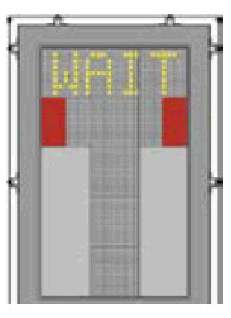 | Pilot to wait and prohibited to docking to centre line without guidance by VDGS. |
IDENTIFICATION The system is activated and in Active mode, scanning for an approaching aircraft and this is indicated by floating arrows.  Instructions to Operators: • Check that the correct aircraft type is displayed on the Pilot Display. The lead-in line is to be followed. Note: If the Safedock system is still in Active mode when the aircraft nose reaches the Passenger Boarding Bridge cab, press the Emergency-Stop button immediately! | 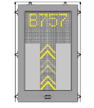 | Pilot /aircraft allow to enter the centre line. |
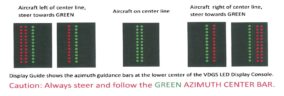
TRACKING The system has captured the aircraft and is actively tracking and verifying it. The floating arrows are replaced by a yellow centre line indicator and floating arrow. • A flashing red and/or yellow arrow indicates the direction to turn for azimuth guidance. • The yellow arrow indicates the aircraft position in relation to the centre line. • The centre line “distance-to-go” indicator changes from floating arrows to a filled closing-rate bar. The closing-rate bar shrinks as the aircraft nears its configured stop position. Instructions to Operators: • Check that the correct aircraft type is displayed on the Pilot Display. When the selected and the verified aircraft type match, the message IDENTIFIED appears on the Operator Panel display. |  | Arrow indicated the aircraft a bit on left side and pilot to turn right and make sure no arrow indicated on the left or right.  |
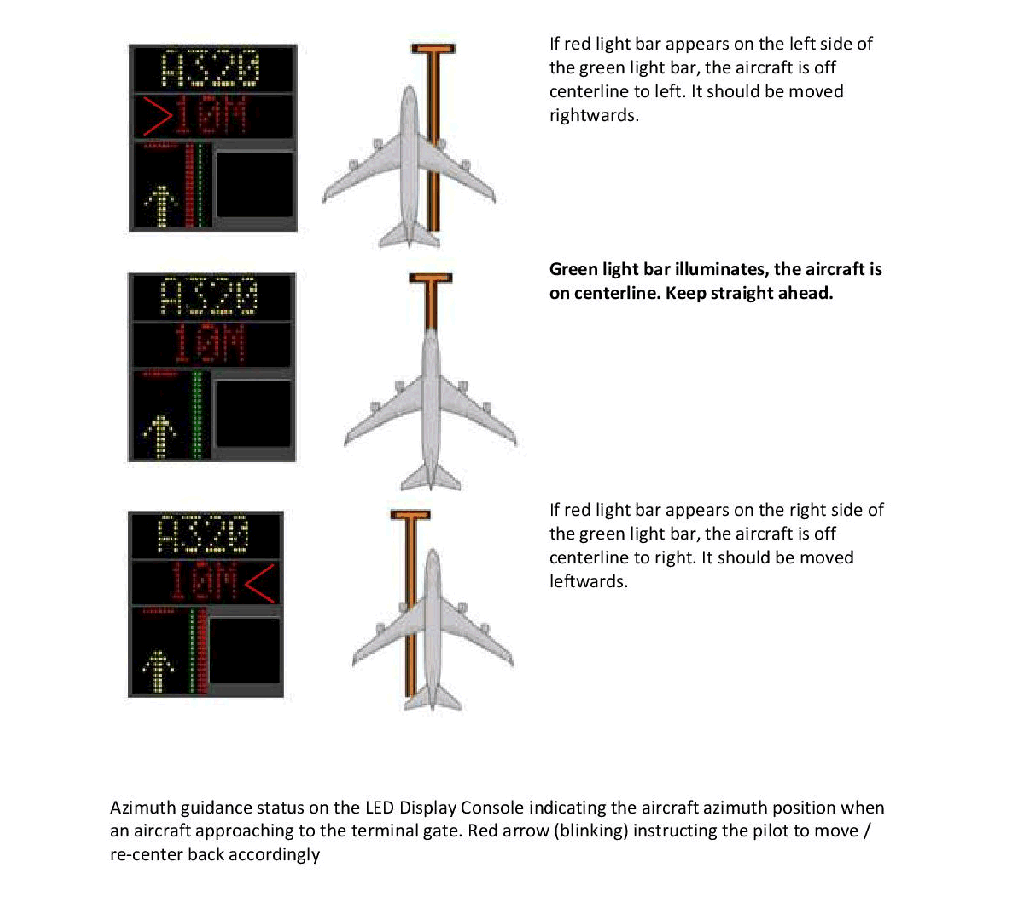
CLOSING RATE The closing rate is the final countdown from a specific distance to the stop-position. A yellow vertical closing rate bar/centreline indicator appears, optionally with a digital countdown indication, depending on the configuration. The closing rate bar showing the distance from stop-position consists of a number of rows representing the remaining distance to go. Each row turns off in steps, beginning 15M from the stop-position as the aircraft approaches, illustrating a shrinking bar from the bottom. As the last row turns off, less than the interval for one row remains until the message STOP appears. A digital countdown (option) shows the distance to stop numerically, with intervals depending on the configuration requirements. The image example illustrates the aircraft in the closing rate distance from stop-position, slightly left of the centre line. The red arrow indicates the direction to steer. |  | Arrow indicated the aircraft a bit on left side and pilot to turn right and make sure no arrow indicated on the left or right. |
ALIGN TO CENTRE LINE The aircraft is at the displayed distance from the stop-position. The absence of any direction arrow indicates an aircraft on the centre line. |  | Aircraft on the centre line and Pilot must ensure the aircraft remain on the centre line until the stop position. |
SLOW DOWN (DECREASE SPEED) The Safedock system is configured with a slowdown active zone. The limit speed for slow down indication is configurable per aircraft type in the 0 - 10M range from the stop-position, with a default setting of 2m/s. The limits further out are fixed: 10 - 20M3m/s; more than 20M 4m/s. Note: A speed of 2m/s is approximately 7km/h, 4 mph or 3 knots. If the aircraft is approaching faster than the accepted speed, the system will show SLOW as a warning to the pilots. |  | Pilot to decrease the aircraft speed. |
AZIMUTH GUIDANCE The aircraft is at the displayed distance from the stop-position. If the aircraft is not aligned to centre, a yellow arrow indicates an aircraft’s position to the centre line, and a red flashing arrow indicates the direction to turn. | 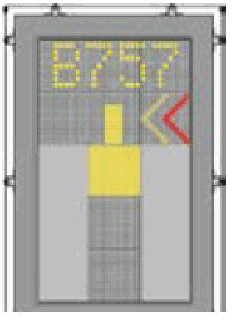 | Pilot to turn a bit left until no indicated red flashing arrow. Pilot to ensure aircraft is slower before reach the stop position. |
STOP POSITION REACHED When the correct stop-position is reached, the Pilot Display will show STOP with a red border or with red lights. If the aircraft is found standing still but has not reached the intended | 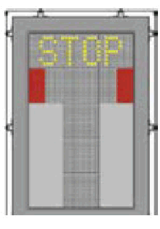 | Pilot to ensure aircraft stop at the stop position. |
DOCKING COMPLETED When the aircraft has parked, the message OK will be displayed. If the aircraft rolls too far past the stop-position, the message TOO FAR appears. After a configurable period of time, the status on the Operator Panel will change to PARKED. Note: If a docking procedure cannot automatically come to a PARKED state, the Marshal can manually set this with the help of the PARK ON command (it is required for enabling the following PARK OFF procedure) | 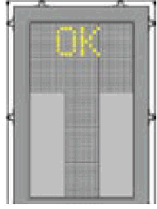 | Docking completed. |
2.0 ABNORMAL CONDITION
| DESCRIPTION | PILOT VIEW | PILOT INSRUCTION |
|---|---|---|
LOST AIRCRAFT DETECTION If the detected aircraft is lost during docking, before 15M to stop-position, the display shows WAIT. The docking continues as soon as the system detects the aircraft again. During penetration into the stand, the aircraft geometry is checked. If, for any reason, aircraft verification is not made 15M before the stop position, the Pilot Display shows STOP and WAIT. Note: This may only be a system event and not a fault. The system requires time for safety checks, apron sweeps, aircraft capture dan ID checks before the closing rate to stop-position (to analyse the possible cause of the incident). | 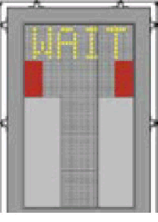 | Pilot to wait and stop before the system being activated. |
OVERSHOOT If the aircraft overshoots the stop-position with a configurable distance, the Pilot Display displays STOP (with RED border/bars) followed by TOO FAR after the aircraft comes to a complete stop. |  | Pilot to aware the aircraft wing span clearance and capability of Passenger Boarding Bridges for passengers disembarking. |
STOP SHORT If the aircraft is found standing still, within a configurable distance up to 5M short of the stop-position, the message STOP and OK will be shown after a configurable amount of time. |  | Pilot to aware the aircraft wing span clearance and capability of Passenger Boarding Bridges for passengers disembarking. |
FAIL AIRCRAFT VERIFICATION (ID FAIL) After capture of the aircraft, its geometry is checked against a stored profile. If, for any reason, aircraft verification is not confirmed 15M before the stop-position, the Pilot Display will show STOP followed by ID FAIL. Below there is a list of errors that can be displayed on the Note: (option) Dockings can be resumed without verification; however it is important to follow the information below. Alternatively, the aircraft shall be marshalled-in or towed-in to the gate.  |  | Pilot to wait for manual docking (marshalling) and stop the aircraft. Pilot to wait and prohibited to docking to centre line without guidance by VDGS or marshaller. |
EMERGENCY E-STOP When the Emergency-Stop button on the Operator Panel is activated, the Pilot Display shows STOP (with red border/bars). Note: Additional Emergency-STOP buttons (other than that on the Operator Panel) may be connected to the system at the apron level. |  | Pilot to ensure the aircraft stop and not precede aircraft movement. |
2.20.12 RLG GIS206-2 AUTOMATED GUIDE-IN SYSTEM AND DOCKING PROCEDURES KLIA TERMINAL 2 (T2)
Figure A:
In this picture the aircraft is at 10 Metres and is on the centre line.
The docking system is not activated
A wrong type of the aircraft indicates ’ NO ID ’ is displayed.
the word STOP is displayed.
The docking system is not activated
A wrong type of aircraft shows ’ NO ID ’ is displayed.
The word STOP is displayed
WMKK AD 2.21 NOISE ABATEMENT PROCEDURES
NIL
WMKK AD 2.22 FLIGHT PROCEDURES
2.22.1 General
2.22.2 AIRPORT COLLABORATIVE DECISION MAKING (A-CDM) OPERATIONS
Target Off Block Time (TOBT) – The time an AO or GHA committed that an aircraft targeted to be ready, all doors closed, boarding bridge removed, pushback vehicle available, and ready to start-up / pushback immediately upon reception of clearance from ATC.
Target Start-Up Approval Time (TSAT) – The time provided by ATC that an aircraft can expect start-up / push back approval.
Calculated Take-Off Time (CTOT) – A time calculated as a result of tactical slot allocation at which a flight is expected to become airborne.
2.22.2.4.1 TOBT Procedure
The airline operator (AO) is responsible for providing the TOBT for each flight. The AO may delegate the TOBT responsible person to the ground handler.
TOBT shall be updated whenever operational changes result into a change of more than +/- 5 minutes from the previous TOBT.
TOBT shall be updated with the use of the following system/application:
A-CDM AOE Mobile
ACIP Native App
TOBT - 40 minutes, only three changes are allowed to be made to the TOBT. In the event further changes need to be made to the TOBT after the third entry, the TOBT must be deleted and the new TOBT needs to be entered.
2.22.2.4.2 A-CDM ATC/Airways Clearance Procedure
Pilots shall request for ATC/airways clearance as following:
For flights to domestic destinations within Peninsular Malaysia including flight to Singapore, pilot in command may initiate the call for ATC clearance from Lumpur Delivery at TSAT -5 minutes.
For flights to destinations beyond KUL FIR, pilots in command may initiate the call for ATC clearance from Lumpur Delivery at TSAT -10 minutes.
Eastbound departures planned along the following ATS route segments can obtain an ATC clearance from Lumpur Delivery at TSAT -30 minutes:
M771 - DUDIS
L625 - AKMON
N884 - LAXOR
Air Traffic Control will update TSAT changes if any, during issuance of ATC/Airways Clearance. The TSAT displayed on the ramp display may not be final and can be revised due to en-route clearance restrictions, ground congestion or flow measures.
2.22.2.4.3 A-CDM Start-Up Request Procedure
The pilots-in-command of all aircraft require clearance from air traffic control for both engine start-up and pushback. All departing aircraft shall contact LUMPUR GROUND for start-up approval at TSAT -/+ 5 minute.
The pilots-in-command of all aircraft may request Start-up clearance from air traffic control for engine start-up and pushback earliest at TSAT -5 minutes but not later than TSAT +5 minutes from LUMPUR GROUND. If the pilot-in-command cannot request start up within the TSAT +/-5 minutes time window a new TSAT needs to be requested and issued via a TOBT update.
An early pushback outside from TSAT window shall not be allowed.
In the event a flight is unable to pushback by TSAT + 5 minutes due to flight constraints, the ATC clearance and the TSAT will be cancelled. Pilot shall update the new TOBT in order to get a new TSAT before requesting a fresh ATC/Airways clearance.
Non-compliance with the initial TSAT may result in an aircraft losing its existing position in the DMAN sequence. Delay can be expected as a result of re-sequencing based on new TOBT input.
In case of delay in pushback due to ground traffic movement or ATC clearance restrictions, the ATC clearance will remain valid even if it exceeds TSAT + 5 minutes. TOBT need not be updated for such cases.
TSAT information will be displayed on the following:
A-CDM Ramp Display
A-CDM Web-based application
A-CDM Mobile Application
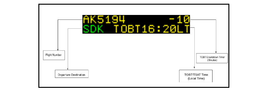
DESCRIPTION | ACDM RAMP DISPLAY |
|---|---|
Arrival flight information Ramp Display will display Arrival Information once ALDT is set:
The display shall be cleared 2 minutes after AIBT. | 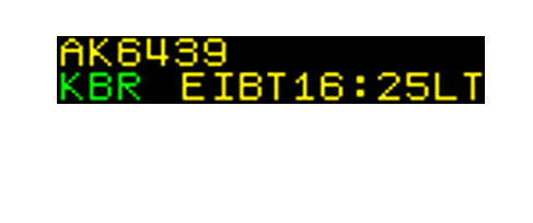 |
40 minutes prior to TOBT Ramp Display will display Departure Information 40 minutes prior to TOBT:
TOBT time stamp will change based on an update by TOBT Responsible Person. Count down will be cleared once timer is 0 (minutes). | 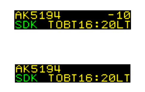 |
40 minutes prior to TSAT Ramp Display will display TSAT 40 minutes prior to TSAT.
Ramp Display will display up to 15 characters per line, the TOBT and TSAT message will be flipped. TSAT time stamp will change based on an update by DMAN based on Pre-Departure Sequencing conditions. The display shall be cleared 1 minute after AOBT | 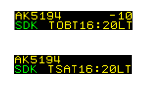 |
2.22.2.6 Non A-CDM Procedure
2.22.2.6.2 During the period of Non A-CDM Operation, pilots shall request for ATC clearance when the aircraft is ready for pushback. ATC will then issue start-up/pushback clearance on a first-come-first-serve basis.
2.22.2.7 Contact and information
2.22.3 Aerodrome Control And Apron Services
From Tower East for Aprons ETN, ETS, ETE, ETW, ESW, ESN and ECS
From Tower West for Aprons WTN, WTS, WTE, WTW, WSN, WSS, WSE and WSW
From Apron Control Tower for Aprons ESE, ESS, ECE, ECN and ECW
Aircraft with respect to other aircraft, vehicles and obstructions;
Vehicles with respect to aircraft.
2.22.4 Communication Services
2.22.5 Approach And Departure Procedures
2.22.5.1 Departing Aircraft
“ATC: "….callsign, recleared on Sepang (…..) Departure"
If a pilot is to fly a radar heading after airbourne: ATC: "callsign, fly heading ..... / maintain runway heading. Climb to .... FT. Runway ....., cleared for take-off"
"…callsign, departure frequency (……), Runway (designator), cleared for take-off."…”
Examples:
If the aircraft is on SID or RD
:“…callsign, ..KIMAT ONE CHARLIE Departure, leaving one thousand seven hundred, climbing to six thousand…”
If the aircraft is on assigned heading
:“…callsign, ..on heading (.....), leaving one thousand seven hundred, climbing to six thousand…”
2.22.5.1.3 Immediate Take-off Clearance
If not yet lined up on the runway, line up and begin take-off run without stopping the aircraft;
if already lined up on the runway, take-off without delay;
if unable to comply with the instruction, inform ATC immediately.
The pilot shall expressly initiate the request for waiver using the phraseology: “callsign...request wake turbulence waiver...”
Waiver on the wake turbulence standard shall apply in VMC by day;
The waiver shall not apply to a LIGHT or MEDIUM aircraft taking off behind a HEAVY aircraft take-off, if the take-off by the LIGHT or MEDIUM aircraft is commenced from a point more than 150 metres along the runway in the direction of take-off, from the commencement point of the HEAVY aircraft take-off.
In VMC;
ATC must have reasonable assurance that the appropriate separation will exist when the succeeding aircraft crosses the runway threshold;
when issuing a landing clearance following the application of the above procedures, ATC will issue the following aircraft with the instruction below:
" Preceding (aircraft type) vacating runway via (taxiway designator), surface wind....Runway (designator) cleared to land,…”
" Preceding (aircraft type) is rolling for departure, surface wind....Runway (designator), cleared to land,…”
2.22.5.4 Height Restrictions (Arriving Aircraft)
2.22.5.4.1 As part of Air Traffic Flow Management measures to regulate arrivals into WMKK.The following height restrictions shall be observed:
PUGER - FL310 OR BLW
NIREN - FL 270 OR BLW
KAKAK - FL 270 OR BLW
PULIP - FL250 OR BLW
SAROX - FL230 OR BLW
GUPTA - FL230 OR BLW
SALAX - FL220 OR BLW
speed control;
radar vectoring; and
holding.
2.22.5.5.4 Pilot shall maintain speed 160 KT IAS at 10 NM untill 5 NM to touchdown.
2.22.5.5.5 Speed Limitation Points When STAR Is Cancelled
Under radar vectors:
250 KIAS on passing 10 000FT;
220 KIAS on turning base;
185 KIAS on turning to intercept the localizer;
160 KIAS from 10NM until 5NM to touchdown.
Own navigation to intercept the final approach track:
250 KIAS on passing 10 000FT;
220 KIAS 20 track miles from touchdown;
185 KIAS 15 track miles from touchdown;
160 KIAS from 10NM until 5NM to touchdown.
Runway designation;
Arrival or Departure;
Type of alert (micro burst or wind shear);
Quantified headwind loss or gain;
Location of alert, in nautical mile, on final approach or departure path.
Example "...callsign...Runway 14L, arrival, microburst alert, headwind loss 40 knots, 2 miles final ".
2.22.7 Visibility Condition
Visibility Condition 1
Horizontal visibility sufficient for pilot to taxi and to avoid collision with other traffic on the taxiways and at intersections by visual reference, and for personnel of air traffic control units to exercise control over all traffic on the basis of visual surveillance; and
The visibility shall not be less than 800 M or 550 M RVR.
Air traffic control shall be responsible for the regulation of aircraft and vehicles with respect to other aircraft and the provision of essential traffic information on aircraft to pilots-in-command and drivers of vehicles to facilitate separation;
Pilots-in-command shall be responsible for maintaining separation with other aircraft on the manoeuvring area, other than the runways;
Drivers of vehicles shall be responsible for separation with aircraft and other vehicles.
Broadcast on the ATIS that low visibility procedures are in operation;
Direct aircraft to use the full length of the runway or the last holding point available for departure (if full length is not available);
Provide runway landing intervals of 6NM or more;
Provide landing clearances no later than 2NM from touchdown;
Provide pilot-in-command of every departing and landing aircraft with the current RVR reading for the relevant runway
Ensure that after landing, the aircraft clears the LSA as soon as possible and report runway vacated;
Be aware that any emergency conditions (brake fire etc.) may not be visible to the control tower or AFRS.
Adjust aircraft taxiing speeds to ensure that they are able to comply with ATC instruction.
2.22.8 Runway Operations
Runway 32R for arrivals, Runway 32L for departures and Runway 33 Mixed Mode;
Runway 32R for departures, Runway 32L for arrivals and Runway 33 Mixed Mode;
Runway 14R for departures, Runway 14L for arrivals and Runway 15 Mixed Mode.
2.22.8.2.1 General
2.22.8.3 Simultaneous Independent Parallel Departure On Triple Runway Operation
2.22.8.3.1.1 This procedure will be implemented between 2330 UTC to 1400 UTC daily when the runway configuration is in Runway 32/33 mode operation only. After the implementation, the runway mode of operation will be as follows:
Runway 32L for departures
Runway 32R for mixed mode; and
Runway 33 for mixed mode.
RWY 33
PUGER 1F
IBUKU 1F
ATIMU 1F
RUSBU 1F
MITOS 1F
SALAX 1F
RWY 32L
PUGER 1E
IBUKU 1E
ATIMU 1E
BIKDU 1E
PIBOS 1E
KIMAT 1E
RUSBU 1E
MITOS 1E
SALAX 1E
RWY 32R
BIKDU 1D
PIBOS 1D
KIMAT 1D
2.22.8.3.1.3 SIDs for triple runway operation in KLIA enable all three parallel runways to be used simultaneously for departures.
Adverse weather conditions;
RWY14/15 mode in use;
Airspace activities (e.g., calibration, flypast);
Runway or taxiway closure.
RWY 14L RNAV (GNSS)
RWY 14R RNAV (GNSS)
RWY 15 RNAV (GNSS)
RWY 32L RNAV (GNSS)
RWY 32R RNAV (GNSS)
RWY 33 RNAV (GNSS)
BTN 1530-2200 UTC on every MON, THU and SUN.
BTN 0300-0400 UTC on every MON
BTN 1530-2200 UTC on every TUE and FRI.
BTN 0300-0400 UTC on every TUE.
BTN 1530-2200 UTC on every WED and SAT.
BTN 0300-0400 UTC on every WED
A 20-minute inspection will be conducted within the period BTN 2100 - 2200 UTC prior to reopening the runway.
An 8-minute inspection will be conducted within the periods BTN 0200 - 0430 UTC, 0800 - 1100 UTC, 1400 - 1600 UTC, and 2100 – 2330 UTC daily.
Additional runway inspection may be conducted as and when required or after weather phenomena.
RWY 14L RNAV (GNSS)
RWY 14R RNAV (GNSS)
RWY 15 RNAV (GNSS)
RWY 32L RNAV (GNSS)
RWY 32R RNAV (GNSS)
RWY 33 RNAV (GNSS)
BTN 1530-2200 UTC on every MON, THU, and SUN
BTN 0300-0400 UTC on every MON
BTN 1530-2200 UTC on every TUE and FRI.
BTN 0300-0400 UTC on every TUE.
BTN 1530-2200 UTC on every WED and SAT.
BTN 0300-0400 UTC on every WED
A 20-minute inspection will be conducted within the period BTN 2100 - 2200 UTC prior to reopening the runway.
An 8-minute inspection will be conducted within the periods BTN 0200 - 0430 UTC, 0800 - 1100 UTC, 1400 - 1600 UTC, and 2100 – 2330 UTC daily.
Additional runway inspection may be conducted as and when required or after weather phenomena.
2.22.9 Runway Crossing
KLIA Terminal 1 (T1) : the area between RWY 32R/14L and RWY 32L/14R (inclusive)
KLIA Terminal 2 (T2) : the area west of RWY 32L/14R until RWY 33/15
2.22.10.0.1 RNAV STAR:
STANDARD ARRIVAL CHART INSTRUMENT - ICAO - RNAV (GNSS) STAR RWY 14L, 14R & 15
STANDARD ARRIVAL CHART INSTRUMENT - ICAO - RNAV (GNSS) STAR RWY 32R, 32L & 33
will only be available for flight planning during certain period of the day. However, the utilization of these STAR shall be determined by ATC subject to operational requirement.
The available slot time of short STARs are shown as per table below.
| NO | TIME (UTC) |
|---|---|
| 1 | 0000 - 0100 |
| 2 | 0100 - 0200 |
| 3 | 1600 - 1700 |
| 4 | 1700 - 1800 |
| 5 | 2100 - 2200 |
PMS East (STAR 1G): KAKAK, PULIP and SAROX;
PMS West (STAR 1H): NIREN, PUGER, SALAX, and GUPTA.
Between 0000-0400 UTC, arrivals shall be assigned based on Operator Parking Terminal assignments (PMS East for Terminal 1 and PMS West for Terminal 2); and
Outside the specified time, all arrivals shall be assigned via PMS West. However, the pilot may request for PMS East subject to ATC approval and traffic situation.
PMS East (STAR 1G): manage arrivals for RWY 32R/32L or RWY 14R/14L;
PMS West (STAR 1H): manage arrivals for RWY 15/33.
Adverse weather conditions;
Single PMS in use;
Airspace activities (e.g., calibration, flypast);
Runway or taxiway closure.
| NO | OPERATION | RWY 15/33 | OTHER RWY | OPERATIONAL HOURS (UTC) | REMARK |
|---|---|---|---|---|---|
| 1 | DUAL PMS | STAR 1H (NIREN, PUGER, SALAX AND GUPTA) | STAR 1G(KAKAK, PULIP ANDSAROX) | 0000 – 1600 | ASSIGNMENT OF THE STAR SHALL BE DEPENDING ON THE DIRECTION OF THE ENTRY POINT. BETWEEN 0000 – 0400 UTC, ENTRY POINT VIA GUPTA, ASSIGNMENT OF THE STAR SHALL DEPEND ON THE OPERATOR PARKING TERMINAL ASSIGNMENT. |
| 2 | MIDNIGHT STAR OR PMS | STAR 3K / STAR 3J / STAR 1G / STAR 1H | 1600 - 0000 | ASSIGNMENT OF THE STAR SHALL BE MADE BY ATC DURING INITIAL CONTACT. STAR 3K / 3J ONLY AVAILABLE BETWEEN 1600 – 2100 UTC. | |
However, in real time, it should be noted that ATC may assign different STARs for ATM measures.
2.22.11.1.1 By default, the PMSs for arrival are the STAR 1 GOLF (1G) on the Eastern and STAR 1 HOTEL (1H) on the Western part of WMKK TMA.
2.22.11.1.2 Operators should refer to the guidance published in ENR 1.8 when filing the Flight Plan, and the assignment of the STAR to WMKK should be based on the operators’ parking terminal as indicated in the table below:
The PMS Operational Hours and the available slot time of SINGLE PMS OPERATION, DUAL PMS OPERATION, MIDNIGHT SIDs and STARs OPERATION and SHORT STARs.
| NO | OPERATION | RWY 15/33 | OTHER RWY | OPERATIONAL HOURS (UTC) | REMARK |
|---|---|---|---|---|---|
| 1 | SINGLE PMS | STAR 1G or 1H | 1400 - 0000 | ASSIGNMENT OF THE STAR SHALL BE MADE BY ATC DURING INITIAL CONTACT | |
| 2 | DUAL PMS | STAR 1H | STAR 1G | 0000 - 1400 | ASSIGNMENT OF THE STAR SHALL BE DEPENDING ON THE OPERATOR PARKING TERMINAL ASSIGNMENT |
| 3 | MIDNIGHT SIDs & STARs | SID 2A, 2B, 2C, 2D, 2E, 2F STAR 3K OR STAR 3J | 1600 - 2100 | THE UTILIZATION OF THESE SID SHALL BE DETERMINED BY ATC SUBJECT TO OPERATIONAL REQUIREMENT | |
| 4 | SHORT STARs | STAR 2K or STAR 2J | 0000 - 0100 | THE UTILIZATION OF THESE STAR SHALL BE DETERMINED BY ATC SUBJECT TO OPERATIONAL REQUIREMENT | |
| 0100 - 0200 | |||||
| 1600 - 1800 | |||||
| 2100 - 2200 | |||||
However, in real time, it should be noted that ATC may assign different STARs for ATM measures.
Destinations within Peninsular Malaysia;
Destinations in Singapore;
Destinations in Indonesia;
Destinations in Thailand; and
Destinations in Vietnam.
The Planned Flight Level (PFL) filed in Field 15b of the flight plan will be used as the requested level unless otherwise specified by the pilot;
An initial climb level will be assigned according to the runway in use. The initial climb altitude will be included in the free-text field (e.g. IL040 indicates an initial climb altitude of 4000 FT);
No on-ground negotiation or reservation of flight levels will be conducted;
The final cruising level will be assigned by Lumpur ATC after airborne and is subject to traffic disposition;
The DCL service does not support clearance revision. Any amendments to a clearance issued via data link will be made by ATC through voice communication; and
Upon receipt of a “REVERT TO VOICE PROCEDURES” message, the pilot shall cancel any previously received clearance (if applicable) and follow the standard voice procedure for clearance requests.
Definitions of commonly used DCL message types and examples of message formats are provided below:
Request for Departure Clearance Downlink (RCD) | Message of the pilot requesting an ATC Clearance. Example: RCD080ABC0123 - WMKK - GATE B09 – WSSS |
Flight System Uplink Message (FSM) | Automatic acknowledgement of receipt of RCD / CDA by the ATC system, or the termination of the DCL service. Example 1: Example 2: Example 3 (NEGATIVE FSM MESSAGE): |
Departure Clearance Uplink Message (CLD) | Issuance of the ATC Clearance by the air traffic controller. Example: |
Departure Clearance Readback Downlink (CDA) | Confirmation of ATC Clearance by pilot. Example: |
Note 1: A departure clearance issued by voice always supersedes a departure clearance transmitted via the DCL service.
Note 2: The DCL service does not support clearance revisions. Any revisions to a clearance issued via data link will be communicated by ATC through voice procedures.
2.22.11.5.6 The pilot shall contact the appropriate LUMPUR GROUND frequency within 5 minutes after successful transmission of the CDA message.
2.22.11.5.7 ATC will reject the DCL request and instruct the pilot to revert to voice procedures in the following circumstances:
The flight destination is not listed in paragraph 2.22.12.2; or
The RCD message does not comply with EUROCAE ED-85A standards or contains inaccurate flight data; or
When deemed necessary by ATC.
2.22.12 HIRO Procedures
KLIA operates with three parallel runways:
Runway 14L/32R
Runway 14R/32L
Runway 15/33
Pilots shall adopt the following speeds when notified that the STAR is cancelled:
Under radar vectors:
185 KIAS on turning to intercept the localizer;
160 KIAS from 10NM until 5NM to touchdown.
Own navigation to intercept the final approach track:
185 KIAS 15 track miles from touchdown;
160 KIAS from 10NM until 5NM to touchdown.
2.22.12.3.5 ATC may issue other speeds to achieve a more accurate spacing, e.g. 220 KIAS prior to base turn.
2.22.12.4 Cancellation of Speed Restrictions.
| RUNWAY IN USE | VACATING RUNWAY TIME (SECONDS) | REMARKS |
|---|---|---|
| 14L / 14R / 15 / 32L / 33 | 60 | Standard ROT requirement during HIRO |
| 32R | 70 | Adjusted due to airport layout characteristics |
| RUNWAY | AIRCRAFT TYPE | TAXIWAY EXITS (* Preferred Exit) | DISTANCE TO TURN-OFF (m) |
|---|---|---|---|
| 14L | All | A06* | 2065 |
| A07 | 2574 | ||
| 14R | All | C07* | 2048 |
| C08 | 2500 | ||
| 15 | All | Y06* | 2182 |
| Y07 | 2632 | ||
| 32R | All | A05* | 2070 |
| A04 | 2520 | ||
| 32L | All | C06* | 2050 |
| C05 | 2507 | ||
| P04* (Aircraft to T2) | 3030 | ||
| 33 | All | Y05* | 2180 |
| Y04 | 2630 |
| RUNWAY | TAXIWAY INTERSECTION | TORA (m) |
|---|---|---|
| 14L | THRESHOLD | 4019 |
| A02 | 3604 | |
| A03 | 2832 | |
| A04 | 2520 | |
| 14R | THRESHOLD | 4000 |
| C02 | 3887 | |
| P02 | 3839 | |
| C03 | 3566 | |
| P03 | 3519 | |
| C04 | 2820 | |
| 15 | THRESHOLD | 3960 |
| Y02 | 3505 | |
| Y03 | 3400 | |
| Y04 | 2630 | |
| 32R | THRESHOLD | 4019 |
| A10 | 3954 | |
| A09 | 3634 | |
| A08 | 2887 | |
| 32L | THRESHOLD | 4000 |
| C10 | 3585 | |
| C09 | 2812 | |
| C08 | 2500 | |
| 33 | THRESHOLD | 3960 |
| Y08 | 3827 | |
| Y07 | 2632 |
Aircraft’s readiness to take off,
Aircraft performance category, and
ATFM measures being applied.
2.22.12.7 Limitation of HIRO
Adverse weather condition;
When the runway condition is not dry and poor runway braking action;
When there is a closure on RET;
Unserviceable of visual aids;
Congested taxiway or apron areas;
Low visibility conditions; and
Emergency situations (HIRO may be suspended to prioritise safety and allow for emergency response actions).
2.22.12.8 Emergency Procedures
2.22.12.8.1 In the event of an emergency, standard emergency procedures will take precedence over HIRO procedures.
WMKK AD 2.23 ADDITIONAL INFORMATION
WMKK AD 2.24 CHARTS RELATED TO AN AERODROME
|
Chart name |
Page |
|---|---|
|
AERODROME/HELIPORT CHART (WMKK) - ICAO | AD 2-WMKK-2-1 |
|
AERODROME AERONAUTICAL GROUND LIGHTINGS AND RUNWAY MARKINGS | AD 2-WMKK-2-3 |
|
AERODROME GROUND LIGHTING CHART | AD 2-WMKK-2-5 |
|
AIRCRAFT PARKING/DOCKING CHART (WMKK) - ICAO (KLIA TERMINAL 1) | AD 2-WMKK-2-7 |
|
AIRCRAFT PARKING/DOCKING CHART (WMKK) - ICAO (KLIA TERMINAL 1) (TABULAR 1) | AD 2-WMKK-2-8 |
|
AIRCRAFT PARKING/DOCKING CHART (WMKK) - ICAO (KLIA TERMINAL 1) (TABULAR 2) | AD 2-WMKK-2-9 |
|
AIRCRAFT PARKING/DOCKING CHART (WMKK) - ICAO (KLIA TERMINAL 1) (TABULAR 3) | AD 2-WMKK-2-10 |
|
AIRCRAFT PARKING/DOCKING CHART (WMKK) - ICAO (KLIA TERMINAL 1) (TABULAR 4) | AD 2-WMKK-2-11 |
|
AIRCRAFT PARKING/DOCKING CHART (WMKK) - ICAO (KLIA TERMINAL 1) (TABULAR 5) | AD 2-WMKK-2-12 |
|
AIRCRAFT PARKING/DOCKING CHART (WMKK) - ICAO (KLIA TERMINAL 1) (TABULAR 6) | AD 2-WMKK-2-13 |
|
AIRCRAFT PARKING/DOCKING CHART (WMKK) - ICAO (KLIA TERMINAL 1) (TABULAR 7) | AD 2-WMKK-2-14 |
|
AIRCRAFT PARKING/DOCKING CHART (WMKK) - ICAO - (KLIA TERMINAL 2) | AD 2-WMKK-2-15 |
|
AIRCRAFT PARKING/DOCKING CHART (WMKK) - ICAO - (KLIA TERMINAL 2) (TABULAR 1) | AD 2-WMKK-2-16 |
|
AIRCRAFT PARKING/DOCKING CHART (WMKK) - ICAO - (KLIA TERMINAL 2) (TABULAR 2) | AD 2-WMKK-2-17 |
|
AIRCRAFT PARKING/DOCKING CHART (WMKK) - ICAO - (KLIA TERMINAL 2) (TABULAR 3) | AD 2-WMKK-2-18 |
|
AIRCRAFT PARKING DOCKING (TABULAR 9) | AD 2-WMKK-2-19 |
|
AERODROME GROUND MOVEMENT CHART - ICAO | AD 2-WMKK-2-21 |
|
AERODROME GROUND MOVEMENT CHART - ICAO (TABULAR 1) | AD 2-WMKK-2-22 |
|
AERODROME GROUND MOVEMENT CHART - ICAO (TABULAR 2) | AD 2-WMKK-2-23 |
|
AERODROME GROUND MOVEMENT CHART - ICAO (TABULAR 3) | AD 2-WMKK-2-24 |
|
AERODROME GROUND MOVEMENT CHART - ICAO (TABULAR 4) | AD 2-WMKK-2-25 |
|
AERODROME GROUND MOVEMENT CHART - ICAO (TABULAR 5) | AD 2-WMKK-2-26 |
|
AERODROME GROUND MOVEMENT CHART - ICAO (TABULAR 6) | AD 2-WMKK-2-27 |
|
TAXI ROUTES (TEXT 1) | AD 2-WMKK-2-28 |
|
TAXI ROUTES (TEXT 2) | AD 2-WMKK-2-29 |
|
TAXI ROUTES ARRIVAL RWY 14L | AD 2-WMKK-2-31 |
|
TAXIWAY ROUTES ARRIVAL RWY 14L (TABULAR 1) | AD 2-WMKK-2-32 |
|
TAXI ROUTES ARRIVAL RWY 14R | AD 2-WMKK-2-33 |
|
TAXIWAY ROUTES ARRIVAL RWY 14R (TABULAR 1) | AD 2-WMKK-2-34 |
|
KLIA TERMINAL 2 TAXI ROUTES ARRIVAL RWY 15 | AD 2-WMKK-2-35 |
|
TAXIWAY ROUTES ARRIVAL RWY 15 TO KLIA TERMINAL 2 (TABULAR 1) | AD 2-WMKK-2-36 |
|
TAXI ROUTES ARRIVAL RWY 32L | AD 2-WMKK-2-37 |
|
TAXIWAY ROUTES ARRIVAL RWY 32L (TABULAR 1) | AD 2-WMKK-2-38 |
|
KLIA TERMINAL 2 TAXI ROUTES ARRIVAL RWY 32L | AD 2-WMKK-2-39 |
|
TAXIWAY ROUTES ARRIVALS RWY 32L TO KLIA TERMINAL 2 (TABULAR 1) | AD 2-WMKK-2-40 |
|
TAXI ROUTES ARRIVAL RWY 32R | AD 2-WMKK-2-41 |
|
TAXIWAY ROUTES ARRIVAL RWY 32R (TABULAR 1) | AD 2-WMKK-2-42 |
|
KLIA TERMINAL 2 TAXI ROUTES ARRIVALS RWY 33 | AD 2-WMKK-2-43 |
|
TAXIWAY ROUTES ARRIVALS RWY 33 TO KLIA TERMINAL 2 (TABULAR 1) | AD 2-WMKK-2-44 |
|
TAXI ROUTES DEPARTURE RWY 14L | AD 2-WMKK-2-45 |
|
TAXIWAY ROUTES DEPARTURE RWY 14L (TABULAR 1) | AD 2-WMKK-2-46 |
|
TAXI ROUTES DEPARTURE RWY 14R | AD 2-WMKK-2-47 |
|
TAXIWAY ROUTES DEPARTURE RWY 14R (TABULAR 1) | AD 2-WMKK-2-48 |
|
KLIA TERMINAL 2 TAXI ROUTES DEPARTURE RWY 14R | AD 2-WMKK-2-49 |
|
TAXIWAY ROUTES DEPARTURES RWY 14R FROM KLIA TERMINAL 2 (TABULAR 1) | AD 2-WMKK-2-50 |
|
KLIA TERMINAL 2 TAXI ROUTES DEPARTURE RWY 15 | AD 2-WMKK-2-51 |
|
TAXIWAY ROUTES DEPARTURES RUNWAY 15 FROM KLIA TERMINAL 2 (TABULAR 1) | AD 2-WMKK-2-52 |
|
TAXI ROUTES DEPARTURE RWY 32L | AD 2-WMKK-2-53 |
|
TAXIWAY ROUTES DEPARTURE RWY 32L (TABULAR 1) | AD 2-WMKK-2-54 |
|
TAXI ROUTES DEPARTURE RWY 32R | AD 2-WMKK-2-55 |
|
TAXIWAY ROUTES DEPARTURE RWY 32R (TABULAR 1) | AD 2-WMKK-2-56 |
|
KLIA TERMINAL 2 TAXI ROUTES DEPARTURE RWY 33 | AD 2-WMKK-2-57 |
|
TAXIWAY ROUTES DEPARTURES RUNWAY 33 FROM KLIA TERMINAL 2 (TABULAR 1) | AD 2-WMKK-2-58 |
|
CODE F TAXIWAYS KLIA TERMINAL 1 & KLIA TERMINAL 2 | AD 2-WMKK-2-59 |
|
TAXI ROUTES CODE F - ARRIVALS RWY 14L | AD 2-WMKK-2-61 |
|
STANDARD TAXI ROUTE - CODE F ARRIVAL RWY 14L (TABULAR 1) | AD 2-WMKK-2-62 |
|
TAXI ROUTES CODE F - ARRIVALS RWY 32R | AD 2-WMKK-2-63 |
|
STANDARD TAXI ROUTE - CODE F ARRIVAL RWY 32R (TABULAR 1) | AD 2-WMKK-2-64 |
|
TAXI ROUTES CODE F - ARRIVALS RWY 14R | AD 2-WMKK-2-65 |
|
STANDARD TAXI ROUTE - CODE F ARRIVAL RWY 14R (TABULAR 1) | AD 2-WMKK-2-66 |
|
TAXI ROUTES CODE F - ARRIVALS RWY 32L | AD 2-WMKK-2-67 |
|
STANDARD TAXI ROUTE - CODE F ARRIVAL RWY 32L (TABULAR 1) | AD 2-WMKK-2-68 |
|
TAXI ROUTE CODE F - ARRIVAL RWY 15 | AD 2-WMKK-2-69 |
|
STANDARD TAXI ROUTE - CODE F ARRIVAL RWY 15 (TABULAR 1) | AD 2-WMKK-2-70 |
|
TAXI ROUTE CODE F - ARRIVAL RWY 33 | AD 2-WMKK-2-71 |
|
STANDARD TAXI ROUTE - CODE F ARRIVAL RWY 33 (TABULAR 1) | AD 2-WMKK-2-72 |
|
TAXI ROUTE CODE F - DEPARTURE RWY 14L | AD 2-WMKK-2-73 |
|
STANDARD TAXI ROUTE - CODE F DEPARTURE RWY 14L (TABULAR 1) | AD 2-WMKK-2-74 |
|
TAXI ROUTE CODE F - DEPARTURE RWY 32R | AD 2-WMKK-2-75 |
|
STANDARD TAXI ROUTE - CODE F DEPARTURE RWY 32R (TABULAR 1) | AD 2-WMKK-2-76 |
|
TAXI ROUTE CODE F - DEPARTURE RWY 14R | AD 2-WMKK-2-77 |
|
STANDARD TAXI ROUTE - CODE F DEPARTURE RWY 14R (TABULAR 1) | AD 2-WMKK-2-78 |
|
TAXI ROUTE CODE F - DEPARTURE RWY 32L | AD 2-WMKK-2-79 |
|
STANDARD TAXI ROUTE - CODE F DEPARTURE RWY 32L (TABULAR 1) | AD 2-WMKK-2-80 |
|
TAXI ROUTE CODE F - DEPARTURE RWY 15 | AD 2-WMKK-2-81 |
|
STANDARD TAXI ROUTE - CODE F DEPARTURE RWY 15 (TABULAR 1) | AD 2-WMKK-2-82 |
|
TAXI ROUTE CODE F - DEPARTURE RWY 33 | AD 2-WMKK-2-83 |
|
STANDARD TAXI ROUTE - CODE F DEPARTURE RWY 33 (TABULAR 1) | AD 2-WMKK-2-84 |
|
KLIA EMERGENCY RESPONSE HELICOPTER LANDING ZONES | AD 2-WMKK-2-85 |
|
AERODROME OBSTACLE CHART — ICAO TYPE A (RWY 14L/32R) | AD 2-WMKK-3-1 |
|
AERODROME OBSTACLE CHART — ICAO TYPE A (RWY 14R/32L) | AD 2-WMKK-3-3 |
|
AERODROME OBSTACLE CHART — ICAO TYPE A (RWY 15/33) | AD 2-WMKK-3-5 |
|
KUALA LUMPUR TMA/CTR | AD 2-WMKK-4-1 |
|
ATC SURVEILLANCE MINIMUM ALTITUDE CHART - ICAO | AD 2-WMKK-4-3 |
|
PRECISION APPROACH TERRAIN - ICAO - RWY 14L | AD 2-WMKK-5-1 |
|
PRECISION APPROACH TERRAIN - ICAO - RWY 14R | AD 2-WMKK-5-3 |
|
PRECISION APPROACH TERRAIN - ICAO - RWY 32L | AD 2-WMKK-5-5 |
|
PRECISION APPROACH TERRAIN - ICAO - RWY 32R | AD 2-WMKK-5-7 |
|
STANDARD DEPARTURE CHART - ICAO - RADAR DEPARTURES | AD 2-WMKK-6-1 |
|
STANDARD DEPARTURE CHART INSTRUMENT (SID) - ICAO - RWY 14L RNAV(GNSS) PUGER 1A BIKDU 1A SALAX 1A IBUKU 1A PIBOS 1A MITOS 1A ATIMU 1A KIMAT 1A RUSBU 1A | AD 2-WMKK-6-3 |
|
STANDARD DEPARTURE CHART INSTRUMENT (SID) - ICAO - RWY 14L RNAV(GNSS) PUGER 1A BIKDU 1A SALAX 1A IBUKU 1A PIBOS 1A MITOS 1A ATIMU 1A KIMAT 1A RUSBU 1A (TABULAR 1) | AD 2-WMKK-6-4 |
|
STANDARD DEPARTURE CHART INSTRUMENT (SID) - ICAO - RWY 14L RNAV(GNSS) PUGER 1A BIKDU 1A SALAX 1A IBUKU 1A PIBOS 1A MITOS 1A ATIMU 1A KIMAT 1A RUSBU 1A (TABULAR 2) | AD 2-WMKK-6-5 |
|
STANDARD DEPARTURE CHART INSTRUMENT (SID) - ICAO - RWY 14L RNAV(GNSS) PUGER 1A BIKDU 1A SALAX 1A IBUKU 1A PIBOS 1A MITOS 1A ATIMU 1A KIMAT 1A RUSBU 1A (TABULAR 3) | AD 2-WMKK-6-6 |
|
STANDARD DEPARTURE CHART - ICAO - RWY 14L RNP 1 (GNSS) PUGER 2A BIKDU 2A SALAX 2A IBUKU 2A PIBOS 2A MITOS 2A ATIMU 2A KIMAT 2A RUSBU 2A | AD 2-WMKK-6-7 |
|
STANDARD DEPARTURE CHART - ICAO - RWY 14L RNP 1 (GNSS) PUGER 2A BIKDU 2A SALAX 2A IBUKU 2A PIBOS 2A MITOS 2A ATIMU 2A KIMAT 2A RUSBU 2A (TABULAR 1) | AD 2-WMKK-6-8 |
|
STANDARD DEPARTURE CHART - ICAO - RWY 14L RNP 1 (GNSS) PUGER 2A BIKDU 2A SALAX 2A IBUKU 2A PIBOS 2A MITOS 2A ATIMU 2A KIMAT 2A RUSBU 2A (TABULAR 2) | AD 2-WMKK-6-9 |
|
STANDARD DEPARTURE CHART - ICAO - RWY 14L RNP 1 (GNSS) PUGER 2A BIKDU 2A SALAX 2A IBUKU 2A PIBOS 2A MITOS 2A ATIMU 2A KIMAT 2A RUSBU 2A(TABULAR 3) | AD 2-WMKK-6-10 |
|
STANDARD DEPARTURE CHART INSTRUMENT (SID) - ICAO - RWY 14R RNAV(GNSS) PUGER 1B BIKDU 1B SALAX 1B IBUKU 1B PIBOS 1B MITOS 1B ATIMU 1B KIMAT 1B RUSBU 1B | AD 2-WMKK-6-7 |
|
STANDARD DEPARTURE CHART INSTRUMENT (SID) - ICAO - RWY 14R RNAV(GNSS) PUGER 1B BIKDU 1B SALAX 1B IBUKU 1B PIBOS 1B MITOS 1B ATIMU 1B KIMAT 1B RUSBU 1B (TABULAR 1) | AD 2-WMKK-6-8 |
|
STANDARD DEPARTURE CHART INSTRUMENT (SID) - ICAO - RWY 14R RNAV(GNSS) PUGER 1B BIKDU 1B SALAX 1B IBUKU 1B PIBOS 1B MITOS 1B ATIMU 1B KIMAT 1B RUSBU 1B (TABULAR 2) | AD 2-WMKK-6-9 |
|
STANDARD DEPARTURE CHART INSTRUMENT (SID) - ICAO - RWY 14R RNAV(GNSS) PUGER 1B BIKDU 1B SALAX 1B IBUKU 1B PIBOS 1B MITOS 1B ATIMU 1B KIMAT 1B RUSBU 1B (TABULAR 3) | AD 2-WMKK-6-10 |
|
STANDARD DEPARTURE CHART INSTRUMENT (SID) - ICAO - RWY 14R DEPARTURES FOR SAAS SUBANG | AD 2-WMKK-6-11 |
|
STANDARD DEPARTURE CHART - ICAO - RWY 14R RNP 1 (GNSS) PUGER 2B BIKDU 2B SALAX 2B IBUKU 2B PIBOS 2B MITOS 2B ATIMU 2B KIMAT 2B RUSBU 2B | AD 2-WMKK-6-17 |
|
STANDARD DEPARTURE CHART - ICAO - RWY 14R RNP 1 (GNSS) PUGER 2B BIKDU 2B SALAX 2B IBUKU 2B PIBOS 2B MITOS 2B ATIMU 2B KIMAT 2B RUSBU 2B (TABULAR 1) | AD 2-WMKK-6-18 |
|
STANDARD DEPARTURE CHART - ICAO - RWY 14R RNP 1 (GNSS) PUGER 2B BIKDU 2B SALAX 2B IBUKU 2B PIBOS 2B MITOS 2B ATIMU 2B KIMAT 2B RUSBU 2B (TABULAR 2) | AD 2-WMKK-6-19 |
|
STANDARD DEPARTURE CHART - ICAO - RWY 14R RNP 1 (GNSS) PUGER 2B BIKDU 2B SALAX 2B IBUKU 2B PIBOS 2B MITOS 2B ATIMU 2B KIMAT 2B RUSBU 2B (TABULAR 3) | AD 2-WMKK-6-20 |
|
STANDARD DEPARTURE CHART INSTRUMENT (SID) - ICAO - RWY 15 RNP 1 (GNSS) PUGER 1C BIKDU 3C SALAX 1C IBUKU 1C PIBOS 3C MITOS 1C ATIMU 1C KIMAT 1C RUSBU 1C | AD 2-WMKK-6-13 |
|
STANDARD DEPARTURE CHART INSTRUMENT (SID) - ICAO - RWY 15 RNP 1 (GNSS) PUGER 1C BIKDU 1C SALAX 1C IBUKU 1C PIBOS 1C MITOS 1C ATIMU 1C KIMAT 1C RUSBU 1C (TABULAR 1) | AD 2-WMKK-6-14 |
|
STANDARD DEPARTURE CHART INSTRUMENT (SID) - ICAO - RWY 15 RNP 1 (GNSS) PUGER 1C BIKDU 1C SALAX 1C IBUKU 1C PIBOS 1C MITOS 1C ATIMU 1C KIMAT 1C RUSBU 1C (TABULAR 2) | AD 2-WMKK-6-15 |
|
STANDARD DEPARTURE CHART INSTRUMENT (SID) - ICAO - RWY 15 RNP 1 (GNSS) PUGER 1C BIKDU 1C SALAX 1C IBUKU 1C PIBOS 1C MITOS 1C ATIMU 1C KIMAT 1C RUSBU 1C (TABULAR 3) | AD 2-WMKK-6-16 |
|
STANDARD DEPARTURE CHART - ICAO - RWY 15 RNP 1 (GNSS) PUGER 2C BIKDU 2C SALAX 2C IBUKU 2C PIBOS 2C MITOS 2C ATIMU 2C KIMAT 2C RUSBU 2C | AD 2-WMKK-6-25 |
|
STANDARD DEPARTURE CHART - ICAO - RWY 15 RNP 1 (GNSS) PUGER 2C BIKDU 2C SALAX 2C IBUKU 2C PIBOS 2C MITOS 2C ATIMU 2C KIMAT 2C RUSBU 2C (TABULAR 1) | AD 2-WMKK-6-26 |
|
STANDARD DEPARTURE CHART - ICAO - RWY 15 RNP 1 (GNSS) PUGER 2C BIKDU 2C SALAX 2C IBUKU 2C PIBOS 2C MITOS 2C ATIMU 2C KIMAT 2C RUSBU 2C (TABULAR 2) | AD 2-WMKK-6-27 |
|
STANDARD DEPARTURE CHART - ICAO - RWY 15 RNP 1 (GNSS) PUGER 2C BIKDU 2C SALAX 2C IBUKU 2C PIBOS 2C MITOS 2C ATIMU 2C KIMAT 2C RUSBU 2C (TABULAR 3) | AD 2-WMKK-6-28 |
|
STANDARD DEPARTURE CHART INSTRUMENT (SID) - ICAO - RWY 32R RNAV(GNSS) PUGER 1D BIKDU 1D SALAX 1D IBUKU 1D PIBOS 1D MITOS 1D ATIMU 1D KIMAT 1D RUSBU 1D | AD 2-WMKK-6-17 |
|
STANDARD DEPARTURE CHART INSTRUMENT (SID) - ICAO - RWY 32R RNAV(GNSS) PUGER 1D BIKDU 1D SALAX 1D IBUKU 1D PIBOS 1D MITOS 1D ATIMU 1D KIMAT 1D RUSBU 1D (TABULAR 1) | AD 2-WMKK-6-18 |
|
STANDARD DEPARTURE CHART INSTRUMENT (SID) - ICAO - RWY 32R RNAV(GNSS) PUGER 1D BIKDU 1D SALAX 1D IBUKU 1D PIBOS 1D MITOS 1D ATIMU 1D KIMAT 1D RUSBU 1D (TABULAR 2) | AD 2-WMKK-6-19 |
|
STANDARD DEPARTURE CHART INSTRUMENT (SID) - ICAO - RWY 32R RNAV(GNSS) PUGER 1D BIKDU 1D SALAX 1D IBUKU 1D PIBOS 1D MITOS 1D ATIMU 1D KIMAT 1D RUSBU 1D (TABULAR 3) | AD 2-WMKK-6-20 |
|
STANDARD DEPARTURE CHART INSTRUMENT (SID) - ICAO - RWY 32R DEPARTURES FOR SAAS SUBANG | AD 2-WMKK-6-21 |
|
STANDARD DEPARTURE CHART - ICAO - RWY 32R RNP 1 (GNSS) PUGER 2D BIKDU 2D SALAX 2D IBUKU 2D PIBOS 2D MITOS 2D ATIMU 2D KIMAT 2D RUSBU 2D | AD 2-WMKK-6-37 |
|
STANDARD DEPARTURE CHART - ICAO - RWY 32R RNP 1 (GNSS) PUGER 2D BIKDU 2D SALAX 2D IBUKU 2D PIBOS 2D MITOS 2D ATIMU 2D KIMAT 2D RUSBU 2D (TABULAR 1) | AD 2-WMKK-6-38 |
|
STANDARD DEPARTURE CHART - ICAO - RWY 32R RNP 1 (GNSS) PUGER 2D BIKDU 2D SALAX 2D IBUKU 2D PIBOS 2D MITOS 2D ATIMU 2D KIMAT 2D RUSBU 2D (TABULAR 2) | AD 2-WMKK-6-39 |
|
STANDARD DEPARTURE CHART - ICAO - RWY 32R RNP 1 (GNSS) PUGER 2D BIKDU 2D SALAX 2D IBUKU 2D PIBOS 2D MITOS 2D ATIMU 2D KIMAT 2D RUSBU 2D (TABULAR 3) | AD 2-WMKK-6-40 |
|
STANDARD DEPARTURE CHART INSTRUMENT (SID) - ICAO - RWY 32L RNAV(GNSS) PUGER 1E BIKDU 1E SALAX 1E IBUKU 1E PIBOS 1E MITOS 1E ATIMU 1E KIMAT 1E RUSBU 1E | AD 2-WMKK-6-23 |
|
STANDARD DEPARTURE CHART INSTRUMENT (SID) - ICAO - RWY 32L RNAV(GNSS) PUGER 1E BIKDU 1E SALAX 1E IBUKU 1E PIBOS 1E MITOS 1E ATIMU 1E KIMAT 1E RUSBU 1E (TABULAR 1) | AD 2-WMKK-6-24 |
|
STANDARD DEPARTURE CHART INSTRUMENT (SID) - ICAO - RWY 32L RNAV(GNSS) PUGER 1E BIKDU 1E SALAX 1E IBUKU 1E PIBOS 1E MITOS 1E ATIMU 1E KIMAT 1E RUSBU 1E (TABULAR 2) | AD 2-WMKK-6-25 |
|
STANDARD DEPARTURE CHART INSTRUMENT (SID) - ICAO - RWY 32L RNAV(GNSS) PUGER 1E BIKDU 1E SALAX 1E IBUKU 1E PIBOS 1E MITOS 1E ATIMU 1E KIMAT 1E RUSBU 1E (TABULAR 3) | AD 2-WMKK-6-26 |
|
STANDARD DEPARTURE CHART INSTRUMENT (SID) - ICAO - RWY 32L RNAV(GNSS) PUGER 1E BIKDU 1E SALAX 1E IBUKU 1E PIBOS 1E MITOS 1E ATIMU 1E KIMAT 1E RUSBU 1E (TABULAR 4) | AD 2-WMKK-6-27 |
|
STANDARD DEPARTURE CHART - ICAO - RWY 32L RNP 1 (GNSS) PUGER 2E BIKDU 2E SALAX 2E IBUKU 2E PIBOS 2E MITOS 2E ATIMU 2E KIMAT 2E RUSBU 2E | AD 2-WMKK-6-47 |
|
STANDARD DEPARTURE CHART - ICAO - RWY 32L RNP 1 (GNSS) PUGER 2E BIKDU 2E SALAX 2E IBUKU 2E PIBOS 2E MITOS 2E ATIMU 2E KIMAT 2E RUSBU 2E (TABULAR 1) | AD 2-WMKK-6-48 |
|
STANDARD DEPARTURE CHART - ICAO - RWY 32L RNP 1 (GNSS) PUGER 2E BIKDU 2E SALAX 2E IBUKU 2E PIBOS 2E MITOS 2E ATIMU 2E KIMAT 2E RUSBU 2E (TABULAR 2) | AD 2-WMKK-6-49 |
|
STANDARD DEPARTURE CHART - ICAO - RWY 32L RNP 1 (GNSS) PUGER 2E BIKDU 2E SALAX 2E IBUKU 2E PIBOS 2E MITOS 2E ATIMU 2E KIMAT 2E RUSBU 2E (TABULAR 3) | AD 2-WMKK-6-50 |
|
STANDARD DEPARTURE CHART INSTRUMENT (SID) - ICAO - RWY 33 RNP 1 (GNSS) PUGER 1F BIKDU 1F SALAX 1F IBUKU 1F PIBOS 1F MITOS 1F ATIMU 1F KIMAT 3F RUSBU 1F | AD 2-WMKK-6-29 |
|
STANDARD DEPARTURE CHART INSTRUMENT (SID) - ICAO - RWY 33 RNP 1 (GNSS) PUGER 1F BIKDU 1F SALAX 1F IBUKU 1F PIBOS 1F MITOS 1F ATIMU 1F KIMAT 3F RUSBU 1F (TABULAR 1) | AD 2-WMKK-6-30 |
|
STANDARD DEPARTURE CHART INSTRUMENT (SID) - ICAO - RWY 33 RNP 1 (GNSS) PUGER 1F BIKDU 1F SALAX 1F IBUKU 1F PIBOS 1F MITOS 1F ATIMU 1F KIMAT 3F RUSBU 1F (TABULAR 2) | AD 2-WMKK-6-31 |
|
STANDARD DEPARTURE CHART INSTRUMENT (SID) - ICAO - RWY 33 RNP 1 (GNSS) PUGER 1F BIKDU 1F SALAX 1F IBUKU 1F PIBOS 1F MITOS 1F ATIMU 1F KIMAT 3F RUSBU 1F (TABULAR 3) | AD 2-WMKK-6-32 |
|
STANDARD DEPARTURE CHART INSTRUMENT (SID) - ICAO - RWY 33 RNP 1 (GNSS) PUGER 1F BIKDU 1F SALAX 1F IBUKU 1F PIBOS 1F MITOS 1F ATIMU 1F KIMAT 3F RUSBU 1F (TABULAR 4) | AD 2-WMKK-6-33 |
|
STANDARD DEPARTURE CHART - ICAO - RWY 33 RNP 1 (GNSS) PUGER 2F BIKDU 2F SALAX 2F IBUKU 2F PIBOS 2F MITOS 2F ATIMU 2F KIMAT 2F RUSBU 2F | AD 2-WMKK-6-57 |
|
STANDARD DEPARTURE CHART - ICAO - RWY 33 RNP 1 (GNSS) PUGER 2F BIKDU 2F SALAX 2F IBUKU 2F PIBOS 2F MITOS 2F ATIMU 2F KIMAT 2F RUSBU 2F (TABULAR 1) | AD 2-WMKK-6-58 |
|
STANDARD DEPARTURE CHART - ICAO - RWY 33 RNP 1 (GNSS) PUGER 2F BIKDU 2F SALAX 2F IBUKU 2F PIBOS 2F MITOS 2F ATIMU 2F KIMAT 2F RUSBU 2F (TABULAR 2) | AD 2-WMKK-6-59 |
|
STANDARD DEPARTURE CHART - ICAO - RWY 33 RNP 1 (GNSS) PUGER 2F BIKDU 2F SALAX 2F IBUKU 2F PIBOS 2F MITOS 2F ATIMU 2F KIMAT 2F RUSBU 2F (TABULAR 3) | AD 2-WMKK-6-60 |
|
STANDARD ARRIVAL CHART - INSTRUMENT (STAR) - ICAO - RWY 32R, 32L, 33, 14L, 14R, 15 RNAV (GNSS) PMS EAST PUGER 1G KAKAK 1G SAROX 1G NIREN 1G PULIP 1G GUPTA 1G SALAX 1G | AD 2-WMKK-7-1 |
|
STANDARD ARRIVAL CHART - INSTRUMENT (STAR) - ICAO - RWY 32R, 32L, 33, 14L, 14R, 15 RNAV (GNSS) PMS EAST PUGER 1G KAKAK 1G SAROX 1G NIREN 1G PULIP 1G GUPTA 1G SALAX 1G (TABULAR 1) | AD 2-WMKK-7-2 |
|
STANDARD ARRIVAL CHART - INSTRUMENT (STAR) - ICAO - RWY 32R, 32L, 33, 14L, 14R, 15 RNAV (GNSS) PMS EAST PUGER 1G KAKAK 1G SAROX 1G NIREN 1G PULIP 1G GUPTA 1G SALAX 1G (TABULAR 2) | AD 2-WMKK-7-3 |
|
STANDARD ARRIVAL CHART - INSTRUMENT (STAR) - ICAO - RWY 32R, 32L, 33, 14L, 14R, 15 RNAV (GNSS) PMS EAST PUGER G KAKAK 1G SAROX 1G NIREN 1G PULIP 1G GUPTA 1G SALAX 1G (TABULAR 3) | AD 2-WMKK-7-4 |
|
STANDARD ARRIVAL CHART - INSTRUMENT (STAR) - ICAO - RWY 32R, 32L, 33, 14L, 14R, 15 RNAV (GNSS) PMS EAST PUGER G KAKAK 1G SAROX 1G NIREN 1G PULIP 1G GUPTA 1G SALAX 1G (TABULAR 4) | AD 2-WMKK-7-5 |
|
STANDARD ARRIVAL CHART - INSTRUMENT (STAR) - ICAO - RWY32R, 32L, 33, 14L, 14R, 15 RNAV (GNSS) PMS WEST PUGER 1H KAKAK 1H SAROX 1H NIREN 1H PULIP 1H GUPTA 1H SALAX 1H | AD 2-WMKK-7-7 |
|
STANDARD ARRIVAL CHART - INSTRUMENT (STAR) - ICAO - RWY32R, 32L, 33, 14L, 14R, 15 RNAV (GNSS) PMS WEST PUGER 1H KAKAK 1H SAROX 1H NIREN 1H PULIP 1H GUPTA 1H SALAX 1H (TABULAR 1) | AD 2-WMKK-7-8 |
|
STANDARD ARRIVAL CHART - INSTRUMENT (STAR) - ICAO - RWY32R, 32L, 33, 14L, 14R, 15 RNAV (GNSS) PMS WEST PUGER 1H KAKAK 1H SAROX 1H NIREN 1H PULIP 1H GUPTA 1H SALAX 1H (TABULAR 2) | AD 2-WMKK-7-9 |
|
STANDARD ARRIVAL CHART - INSTRUMENT (STAR) - ICAO - RWY32R, 32L, 33, 14L, 14R, 15 RNAV (GNSS) PMS WEST PUGER 1H KAKAK 1H SAROX 1H NIREN 1H PULIP 1H GUPTA 1H SALAX 1H (TABULAR 3) | AD 2-WMKK-7-10 |
|
STANDARD ARRIVAL CHART - INSTRUMENT (STAR) - ICAO - RWY32R, 32L, 33, 14L, 14R, 15 RNAV (GNSS) PMS WEST PUGER 1H KAKAK 1H SAROX 1H NIREN 1H PULIP 1H GUPTA 1H SALAX 1H (TABULAR 4) | AD 2-WMKK-7-11 |
|
STANDARD ARRIVAL CHART - INSTRUMENT (STAR) - ICAO - RWY32R, 32L, 33 RNAV (GNSS) PMS SOUTH PUGER 1J KAKAK 1J SAROX 1J NIREN 1 J PULIP 1J GUPTA 1J SALAX 1J | AD 2-WMKK-7-13 |
|
STANDARD ARRIVAL CHART - INSTRUMENT (STAR) - ICAO - RWY32R, 32L, 33 RNAV (GNSS) PMS SOUTH PUGER 1J KAKAK 1J SAROX 1J NIREN 1 J PULIP 1J GUPTA 1J SALAX 1J (TABULAR 1) | AD 2-WMKK-7-14 |
|
STANDARD ARRIVAL CHART - INSTRUMENT (STAR) - ICAO - RWY32R, 32L, 33 RNAV (GNSS) PMS SOUTH PUGER 1J KAKAK 1J SAROX 1J NIREN 1 J PULIP 1J GUPTA 1J SALAX 1J (TABULAR 2) | AD 2-WMKK-7-15 |
|
STANDARD ARRIVAL CHART - INSTRUMENT (STAR) - ICAO - RWY32R, 32L, 33, RNAV (GNSS) PMS SOUTH PUGER 1J KAKAK 1J SAROX 1J NIREN 1J PULIP 1J GUPTA 1J SALAX 1J (TABULAR 3) | AD 2-WMKK-7-16 |
|
STANDARD ARRIVAL CHART - INSTRUMENT (STAR) - ICAO - RWY32R, 32L, 33, RNAV (GNSS) PMS SOUTH PUGER 1J KAKAK 1J SAROX 1J NIREN 1J PULIP 1J GUPTA 1J SALAX 1J (TABULAR 4) | AD 2-WMKK-7-17 |
|
STANDARD ARRIVAL CHART - ICAO - RWY 32R, 32L, 33 RNP 1 (GNSS) PUGER 3J KAKAK 3J SAROX 3J NIREN 3J PULIP 3J GUPTA 3J SALAX 3J | AD 2-WMKK-7-19 |
|
STANDARD ARRIVAL CHART - ICAO - RWY 32R, 32L, 33 RNP 1 (GNSS) PUGER 3J KAKAK 3J SAROX 3J NIREN 3J PULIP 3J GUPTA 3J SALAX 3J (TABULAR 1) | AD 2-WMKK-7-20 |
|
STANDARD ARRIVAL CHART - ICAO - RWY 32R, 32L, 33 RNP 1 (GNSS) PUGER 3J KAKAK 3J SAROX 3J NIREN 3J PULIP 3J GUPTA 3J SALAX 3J (TABULAR 2) | AD 2-WMKK-7-21 |
|
STANDARD ARRIVAL CHART - INSTRUMENT (STAR) - ICAO - RWY 14L, 14R, 15 RNAV(GNSS) PMS NORTH PUGER 1K KAKAK 1K SAROX 1K NIREN 1K PULIP 1K GUPTA 1K SALAX 1K | AD 2-WMKK-7-23 |
|
STANDARD ARRIVAL CHART - INSTRUMENT (STAR) - ICAO - RWY 14L, 14R, 15 RNAV(GNSS) PMS NORTH PUGER 1K KAKAK 1K SAROX 1K NIREN 1K PULIP 1K GUPTA 1K SALAX 1K (TABULAR 1) | AD 2-WMKK-7-24 |
|
STANDARD ARRIVAL CHART - INSTRUMENT (STAR) - ICAO - RWY 14L, 14R, 15 RNAV(GNSS) PMS NORTH PUGER 1K KAKAK 1K SAROX 1K NIREN 1K PULIP 1K GUPTA 1K SALAX 1K (TABULAR 2) | AD 2-WMKK-7-25 |
|
STANDARD ARRIVAL CHART - INSTRUMENT (STAR) - ICAO - RWY 14L, 14R, 15 RNAV(GNSS) PMS NORTH PUGER 1K KAKAK 1K SAROX 1K NIREN 1K PULIP 1K GUPTA 1K SALAX 1K (TABULAR 3) | AD 2-WMKK-7-26 |
|
STANDARD ARRIVAL CHART INSTRUMENT (STAR) - ICAO - RWY 14L, 14R, 15 RNAV (GNSS) PUGER 2K KAKAK 2K SAROX 2K NIREN 2K PULIP 2K GUPTA 2K SALAX 2K | AD 2-WMKK-7-27 |
|
STANDARD ARRIVAL CHART INSTRUMENT (STAR) - ICAO - RWY 14L, 14R, 15 RNAV (GNSS) PUGER 2K KAKAK 2K SAROX 2K NIREN 2K PULIP 2K GUPTA 2K SALAX 2K (TABULAR 1) | AD 2-WMKK-7-28 |
|
STANDARD ARRIVAL CHART INSTRUMENT (STAR) - ICAO - RWY 14L, 14R, 15 RNAV (GNSS) PUGER 2K KAKAK 2K SAROX 2K NIREN 2K PULIP 2K GUPTA 2K SALAX 2K (TABULAR 2) | AD 2-WMKK-7-29 |
|
STANDARD ARRIVAL CHART - ICAO - RWY 14L, 14R, 15 RNP 1 (GNSS) PUGER 3K KAKAK 3K SAROX 3K NIREN 3K PULIP 3K GUPTA 3K SALAX 3K | AD 2-WMKK-7-27 |
|
STANDARD ARRIVAL CHART - ICAO - RWY 14L, 14R, 15 RNP 1 (GNSS) PUGER 3K KAKAK 3K SAROX 3K NIREN 3K PULIP 3K GUPTA 3K SALAX 3K (TABULAR 1) | AD 2-WMKK-7-28 |
|
STANDARD ARRIVAL CHART - ICAO - RWY 14L, 14R, 15 RNP 1 (GNSS) PUGER 3K KAKAK 3K SAROX 3K NIREN 3K PULIP 3K GUPTA 3K SALAX 3K (TABULAR 2) | AD 2-WMKK-7-29 |
|
STANDARD ARRIVAL CHART INSTRUMENT (STAR) - ICAO - RWY 32R, 32L, 33 RNAV (GNSS) PUGER 2J KAKAK 2J SAROX 2J NIREN 2J PULIP 2J GUPTA 2J SALAX 2J | AD 2-WMKK-7-35 |
|
STANDARD ARRIVAL CHART INSTRUMENT (STAR) - ICAO - RWY 32R, 32L, 33 RNAV (GNSS) PUGER 2J KAKAK 2J SAROX 2J NIREN 2J PULIP 2J GUPTA 2J SALAX 2J (TABULAR 1) | AD 2-WMKK-7-36 |
|
STANDARD ARRIVAL CHART INSTRUMENT (STAR) - ICAO - RWY 32R, 32L, 33 RNAV (GNSS) PUGER 2J KAKAK 2J SAROX 2J NIREN 2J PULIP 2J GUPTA 2J SALAX 2J (TABULAR 2) | AD 2-WMKK-7-37 |
|
INITIAL APPROACH CHART - RWY 14L RNAV (GNSS) INITIAL APPROACH PROCEDURE VIA PMS EAST / WEST / NORTH | AD 2-WMKK-7-31 |
|
INITIAL APPROACH CHART - RWY 14L RNAV (GNSS) INITIAL APPROACH PROCEDURE VIA PMS EAST / WEST / NORTH (TABULAR 1) | AD 2-WMKK-7-32 |
|
INITIAL APPROACH CHART - RWY 14R RNAV (GNSS) INITIAL APPROACH PROCEDURE VIA PMS EAST / WEST / NORTH | AD 2-WMKK-7-33 |
|
INITIAL APPROACH CHART - RWY 14R RNAV (GNSS) INITIAL APPROACH PROCEDURE VIA PMS EAST / WEST / NORTH (TABULAR 1) | AD 2-WMKK-7-34 |
|
INITIAL APPROACH CHART - RWY 15 RNAV (GNSS) INITIAL APPROACH PROCEDURE VIA PMS EAST / WEST / NORTH | AD 2-WMKK-7-35 |
|
INITIAL APPROACH CHART - RWY 15 RNAV (GNSS) INITIAL APPROACH PROCEDURE VIA PMS EAST / WEST / NORTH (TABULAR 1) | AD 2-WMKK-7-36 |
|
INITIAL APPROACH CHART - RWY 32L RNAV (GNSS) INITIAL APPROACH PROCEDURE VIA PMS EAST / WEST / SOUTH | AD 2-WMKK-7-37 |
|
INITIAL APPROACH CHART - RWY 32L RNAV (GNSS) INITIAL APPROACH PROCEDURE VIA PMS EAST / WEST / SOUTH (TABULAR 1) | AD 2-WMKK-7-38 |
|
INITIAL APPROACH CHART - RWY 32R RNAV (GNSS) INITIAL APPROACH PROCEDURE VIA PMS EAST / WEST / SOUTH | AD 2-WMKK-7-39 |
|
INITIAL APPROACH CHART - RWY 32R RNAV (GNSS) INITIAL APPROACH PROCEDURE VIA PMS EAST / WEST / SOUTH (TABULAR 1) | AD 2-WMKK-7-40 |
|
INITIAL APPROACH CHART - RWY 33 RNAV (GNSS) INITIAL APPROACH PROCEDURE VIA PMS EAST / WEST / SOUTH | AD 2-WMKK-7-41 |
|
INITIAL APPROACH CHART - RWY 33 RNAV (GNSS) INITIAL APPROACH PROCEDURE VIA PMS EAST / WEST / SOUTH (TABULAR 1) | AD 2-WMKK-7-42 |
|
INSTRUMENT APPROACH CHART - ICAO - RWY 14L ILS OR LOC | AD 2-WMKK-8-1 |
|
INSTRUMENT APPROACH CHART - ICAO - RWY 14L ILS OR LOC (TABULAR 1) | AD 2-WMKK-8-2 |
|
INSTRUMENT APPROACH CHART - ICAO - RWY 14L RNP Y | AD 2-WMKK-8-3 |
|
INSTRUMENT APPROACH CHART - ICAO - RWY 14L RNP Y (TABULAR 1) | AD 2-WMKK-8-4 |
|
INSTRUMENT APPROACH CHART - ICAO - RWY 14L RNP X | AD 2-WMKK-8-5 |
|
INSTRUMENT APPROACH CHART - ICAO - RWY 14L RNP X (TABULAR 1) | AD 2-WMKK-8-6 |
|
INSTRUMENT APPROACH CHART - ICAO - RWY 14L VOR/DME | AD 2-WMKK-8-7 |
|
INSTRUMENT APPROACH CHART - ICAO - RWY 14L VOR/DME (TABULAR 1) | AD 2-WMKK-8-8 |
|
INSTRUMENT APPROACH CHART - ICAO - RWY14R ILS OR LOC | AD 2-WMKK-8-9 |
|
INSTRUMENT APPROACH CHART - ICAO - RWY14R ILS OR LOC (TABULAR 1) | AD 2-WMKK-8-10 |
|
INSTRUMENT APPROACH CHART - ICAO - RWY 14R RNP Y | AD 2-WMKK-8-11 |
|
INSTRUMENT APPROACH CHART - ICAO - RWY 14R RNP Y (TABULAR 1) | AD 2-WMKK-8-12 |
|
INSTRUMENT APPROACH CHART - ICAO - RWY 14R RNP X | AD 2-WMKK-8-13 |
|
INSTRUMENT APPROACH CHART - ICAO - RWY 14R RNP X (TABULAR 1) | AD 2-WMKK-8-14 |
|
INSTRUMENT APPROACH CHART - ICAO - RWY 15 ILS OR LOC | AD 2-WMKK-8-15 |
|
INSTRUMENT APPROACH CHART - ICAO - RWY 15 ILS OR LOC (TABULAR 1) | AD 2-WMKK-8-16 |
|
INSTRUMENT APPROACH CHART - ICAO - RWY 15 RNP Y | AD 2-WMKK-8-17 |
|
INSTRUMENT APPROACH CHART - ICAO - RWY 15 RNP Y (TABULAR 1) | AD 2-WMKK-8-18 |
|
INSTRUMENT APPROACH CHART - ICAO - RWY 15 RNP X | AD 2-WMKK-8-19 |
|
INSTRUMENT APPROACH CHART - ICAO - RWY 15 RNP X (TABULAR 1) | AD 2-WMKK-8-20 |
|
INSTRUMENT APPROACH CHART - ICAO - RWY 15 VOR/DME | AD 2-WMKK-8-21 |
|
INSTRUMENT APPROACH CHART - ICAO - RWY 15 VOR/DME (TABULAR 1) | AD 2-WMKK-8-22 |
|
INSTRUMENT APPROACH CHART - ICAO - RWY 32L ILS OR LOC | AD 2-WMKK-8-23 |
|
INSTRUMENT APPROACH CHART - ICAO - RWY 32L ILS OR LOC (TABULAR 1) | AD 2-WMKK-8-24 |
|
INSTRUMENT APPROACH CHART - ICAO - RWY 32L RNP Y | AD 2-WMKK-8-25 |
|
INSTRUMENT APPROACH CHART - ICAO - RWY 32L RNP Y (TABULAR 1) | AD 2-WMKK-8-26 |
|
INSTRUMENT APPROACH CHART - ICAO - RWY 32L RNP X | AD 2-WMKK-8-27 |
|
INSTRUMENT APPROACH CHART - ICAO - RWY 32L RNP X (TABULAR 1) | AD 2-WMKK-8-28 |
|
INSTRUMENT APPROACH CHART - ICAO - RWY 32R ILS OR LOC | AD 2-WMKK-8-29 |
|
INSTRUMENT APPROACH CHART - ICAO - RWY 32R ILS OR LOC (TABULAR 1) | AD 2-WMKK-8-30 |
|
INSTRUMENT APPROACH CHART - ICAO - RWY 32R RNP Z (AR) | AD 2-WMKK-8-31 |
|
INSTRUMENT APPROACH CHART - ICAO - RWY 32R RNP Z (AR) (TABULAR 1) | AD 2-WMKK-8-32 |
|
INSTRUMENT APPROACH CHART - ICAO - RWY 32R RNP Z (AR) (TABULAR 2) | AD 2-WMKK-8-33 |
|
INSTRUMENT APPROACH CHART - ICAO - RWY 32R RNP Y | AD 2-WMKK-8-35 |
|
INSTRUMENT APPROACH CHART - ICAO - RWY 32R RNP Y (TABULAR 1) | AD 2-WMKK-8-36 |
|
INSTRUMENT APPROACH CHART - ICAO - RWY 32R RNP X | AD 2-WMKK-8-37 |
|
INSTRUMENT APPROACH CHART - ICAO - RWY 32R RNP X (TABULAR 1) | AD 2-WMKK-8-38 |
|
INSTRUMENT APPROACH CHART - ICAO - RWY 32R VOR/DME | AD 2-WMKK-8-39 |
|
INSTRUMENT APPROACH CHART - ICAO - RWY 32R VOR/DME (TABULAR 1) | AD 2-WMKK-8-40 |
|
INSTRUMENT APPROACH CHART - ICAO - RWY 33 ILS OR LOC | AD 2-WMKK-8-41 |
|
INSTRUMENT APPROACH CHART - ICAO - RWY 33 ILS OR LOC (TABULAR 1) | AD 2-WMKK-8-42 |
|
INSTRUMENT APPROACH CHART - ICAO - RWY 33 RNP Z (AR) | AD 2-WMKK-8-43 |
|
INSTRUMENT APPROACH CHART - ICAO - RWY 33 RNP Z (AR) (TABULAR 1) | AD 2-WMKK-8-44 |
|
INSTRUMENT APPROACH CHART - ICAO - RWY 33 RNP Z (AR) (TABULAR 2) | AD 2-WMKK-8-45 |
|
INSTRUMENT APPROACH CHART - ICAO - RWY 33 RNP Y | AD 2-WMKK-8-47 |
|
INSTRUMENT APPROACH CHART - ICAO - RWY 33 RNP Y (TABULAR 1) | AD 2-WMKK-8-48 |
|
INSTRUMENT APPROACH CHART - ICAO - RWY 33 RNP X | AD 2-WMKK-8-49 |
|
INSTRUMENT APPROACH CHART - ICAO - RWY 33 RNP X (TABULAR 1) | AD 2-WMKK-8-50 |
|
INSTRUMENT APPROACH CHART - ICAO - RWY 33 VOR/DME | AD 2-WMKK-8-51 |
|
INSTRUMENT APPROACH CHART - ICAO - RWY 33 VOR/DME (TABULAR 1) | AD 2-WMKK-8-52 |