ENR 1.6  ATS SURVEILLANCE SERVICES AND PROCEDURES

1.6.1  Use Of Radar In Air Traffic Service

1.6.1.1  General
1.6.1.1.1 Except for some lower levels on the eastern coast, radar coverage of ATS routes in Peninsular Malaysia is all but complete. Traffic separation is therefore based to a large degree on radar separation standards, especially in the vicinity of Kuala Lumpur where significant levels of radar and system redundancy are available.
1.6.1.1.2 Notwithstanding this redundancy, procedural standards have been developed as a fallback to cater for abnormal operations.
1.6.1.1.3 In the enroute and terminal airspace, radar is used to:
  1. monitor separation between aircraft during transition from one radar standard to another or to a procedural separation standard;

  2. continuously monitor aircraft at the same level and on the same route at a stable radar separation;

  3. provide active radar separation between same direction, opposite direction or converging aircraft by radar vectoring or altitude assignment or a combination of both.

1.6.1.1.4 In the Kuala Lumpur FIR and Kota Kinabalu FIR, surveillance services are provided using the following civil/military ATC Radars:
  1. A 200 NM long range en-route SSR located at Bukit Chin Chin, Genting Highlands, 23 NM east of Subang/Sultan Abdul Aziz ShahAirport.

  2. A 60 NM Terminal Primary Approach Radar co-mounted with a 200 NM monopulse SSR located to the west of Johor Bahru/Senai International Airport runway.

  3. A 60 NM Primary Surveillance Radar (PSR) co-mounted with 200 NM monopulse SSR located on Bukit Subang, 1 NM west of Subang/Sultan Abdul Aziz Shah Airport.

  4. A Transportable Radar, 60 NM Primary Surveillance Radar (PSR) co-mounted with 200 NM monopulse SSR located at KL International / Sepang Airport.

  5. KL International / Sepang Terminal Approach Radar - A 60 NM Primary Surveillance Radar (PSR) comounted with 200 NM monopulse SSR located at KL International / Sepang Airport.

  6. A 60 NM Primary Surveillance Radar (PSR) co-mounted with 200 NM monopulse SSR located on Hill Chengkuang 1.5 NM NE of Langkawi International Airport.

  7. A 60 NM Terminal Primary Approach Radar co-mounted with a 200 NM monopulse SSR located to the south of Kota Bharu/Sultan Ismail Petra Airport runway.

  8. A 60 NM Primary Surveillance Radar (PSR) co-mounted with 200 NM monopulse SSR located on Bukit Kepayang, 1 NM NE of Kota Kinabalu International Airport.

  9. A 60 NM Primary Surveillance Radar (PSR) co-mounted with 200 NM monopulse SSR located in Kuching International Airport.

  10. A 60 NM Terminal Primary Approach Radar co-mounted with a 200 NM monopulse SSR located at Miri Airport.

  11. A 80 NM Terminal Approach Radar with co-mounted 250 NM monopulse SSR-Mode S located one each at Gong Kedak and Butterworth Air Force Bases.

  12. A 80 NM Terminal Approach Radar with co-mounted 250 NM monopulse SSR located at Labuan Air Force Base.

  13. A 100 NM Terminal Approach Radar with co-mounted 200 NM conventional SSR located at Kuantan Air Force Base.

  14. A 60 NM Terminal Primary Approach Radar co-mounted with a 200 NM monopulse SSR located at Sibu Airport.

  15. A 80 NM Primary Surveillance Radar (PSR) co-mounted with a 256 NM monopulse SSR located at Sandakan Airport.

  16. A 60 NM Terminal Primary Approach Radar co-mounted with a 200 NM monopulse SSR located at Tawau Airport.

  17. A 250 NM monopulse SSR with MODE-S capability at Mersing Radar Site.

  18. A 250 NM ADS-B located at Genting Radar Site.

  19. A 250 NM ADS-B located at Gunung Raya, Langkawi.

  20. A 250 NM ADS-B located at Kuala Terengganu/Sultan Mahmud Airport.

  21. A 250 NM ADS-B located at Kuching International Airport.

  22. A 250 NM ADS-B located at Bintulu Airport

  23. A 250 NM ADS-B located at Kota Kinabalu International Airport.

  24. A 250 NM ADS-B located at Sandakan Airport.

1.6.1.2  Types Of Surveillance Services
1.6.1.2.1 Radar units in the Kuala Lumpur FIR and Kota Kinabalu FIR operate as integral parts of ATS system and provide the following services:
  1. Radar Control Service - Provided to all identified aircraft operating in airspace classification A, B and C within coverage of the appropriate radar sensor. It involves monitoring the navigation of, or issuance of heading instructions to aircraft to ensure that radar separation is maintained.

  2. Radar Advisory Service - Provided to identified aircraft operating in airspace classification G. involves the provision of position information to assist in its navigation, essential traffic information and assistance to aircraft in emergency. Aircraft receiving such service are not obliged to follow the advice given.

  3. Radar Flight Information Service Provided to identified aircraft in all airspace within radar coverage and involves provision of flight information necessary for the safe and efficient conduct of flights.

  4. Weather Avoidance Advice

    1. ATC may provide advice to aircraft for weather avoidance. Aircraft receiving such service are not obliged to follow the advice given.

    2. Should an aircraft need to change heading for weather avoidance, the pilot shall obtain an Air Traffic Control Clearance.

    3. Should an aircraft leave controlled airspace due to weather avoidance, the pilot shall obtain an ATC clearance to re-enter controlled airspace.

1.6.1.3  Radar Separation Standards
1.6.1.3.1 The horizontal radar separation minima shall be:

Within the Kuala Lumpur FIR

  1. 3 NM - i) Within CTR and/or TMA but not more than 40 NM from the radar head.

    ii) Both PSR and SSR are operating.

  2. 5 NM - Other than the situation as specified in (a) above.

Within the Kota Kinabalu FIR

  1. 5 NM

1.6.1.3.2 It is not always possible to specify a separation minima between identified and unknown aircraft considered to constitute a hazard due to unpredictable manoeuvres of the latter. However, whenever practicable, the minimum radar separation will be applied.
1.6.1.3.3 When radar separation is being applied, aircraft shall not deviate from its track / heading without prior approval from the ATC radar unit.
1.6.1.3.4 When instructed to 'Resume own navigation for........ (RP or waypoint)', the pilot should intercept the published track to that point at an angle between 30 and 40 degrees, unless a clearance to 'Track direct to........ (RP or waypoint) has been included.
1.6.1.4  Unknown Aircraft
1.6.1.4.1 ATC will provide to identified aircraft, information on the movement of unknown aircraft deemed to constitute a collision hazard. Avoiding action may be suggested if considered necessary, or if requested by the pilot. The decision to comply with the ATC suggestion rests with the pilot.
1.6.1.5  Terrain Clearance
1.6.1.5.1 Surveillance control service shall include terrain clearance monitoring for arriving and departing aircraft. During the enroute phase, levels given by ATC shall not be below the minimum IFR altitude for the route.
1.6.1.5.2 An ATC Surveillance Minimum Altitude chart defines the minimum altitudes that may be assigned within 40 NM of an airfield. This provides at least 1000 ft vertical clearance above obstacles within 5 NM of the aircraft's position.
1.6.1.5.3 The onus of terrain clearance may be given to the pilot of an arriving aircraft, by daylight only, when he reports that he is visual with terrain, and the reported cloud ceiling is not below the minimum for the initial approach of that route.
1.6.1.5.4 Minimum Safe Altitude Warning (MSAW) system is fitted to the Terminal Approach Radars serving the Kuala Lumpur TMA, Kota Kinabalu TMA and Kuching TMA. It provides the Controller with an alert in the SSR label when the Mode C (altitude) of the transponder indicates a minimum of 300 ft below the defined safe altitude within the MSAW areas. Controllers will advise pilots "... C/S, MSAW Alert, climb immediately to ...." or "... C/S, Altitude Alert, climb immediately to...". It will be the pilot's responsibility whether to continue the flight at that level, or climb to a higher level. He should inform ATC of his intentions. This warning will only be given during radar monitored descents, not for visual contact descents.
1.6.1.6  Speed Control
1.6.1.6.1 Speed control shall be used to reduce the need for radar vectoring in the establishment of an approach sequence or to facilitate surveillance control. Unless a speed restriction is issued by ATC, pilots shall plan their “top of descent” based on 270 KIAS. They are also expected to observe subsequent speed restrictions, if any, that may apply for individual aerodromes.
1.6.1.6.2 Pilots unable to comply with the speed restriction shall inform ATC immediately for alternative instructions. When a speed restriction is no longer required, ATC shall instruct the pilot to resume desired speed.
1.6.1.6.3 Above FL 240, Indicated Airspeed (IAS) values shall not be used for speed control as this provides inaccurate values. Instead, speed control shall be based on Ground Speed or Mach No.
1.6.1.6.4 Speed control shall automatically terminate upon clearance to final approach, or visual approach unless specifically specified by ATC or indicated under aerodrome flight procedures of specific aerodromes.
1.6.1.7  Surveillance Services To VFR Aircraft
1.6.1.7.1 Within controlled airspace, surveillance services provided to VFR aircraft shall be similar to that provided to IFR aircraft. Radar Vectoring service may be provided when requested by the pilot, or with pilot concurrence when suggested by ATC.
1.6.1.7.2 As the radar controller will not know if flight into instrument meteorological conditions (IMC) will result from his instructions, pilots shall inform the radar controller accordingly before entering IMC together with their intentions.
1.6.1.8  Emergency Procedure
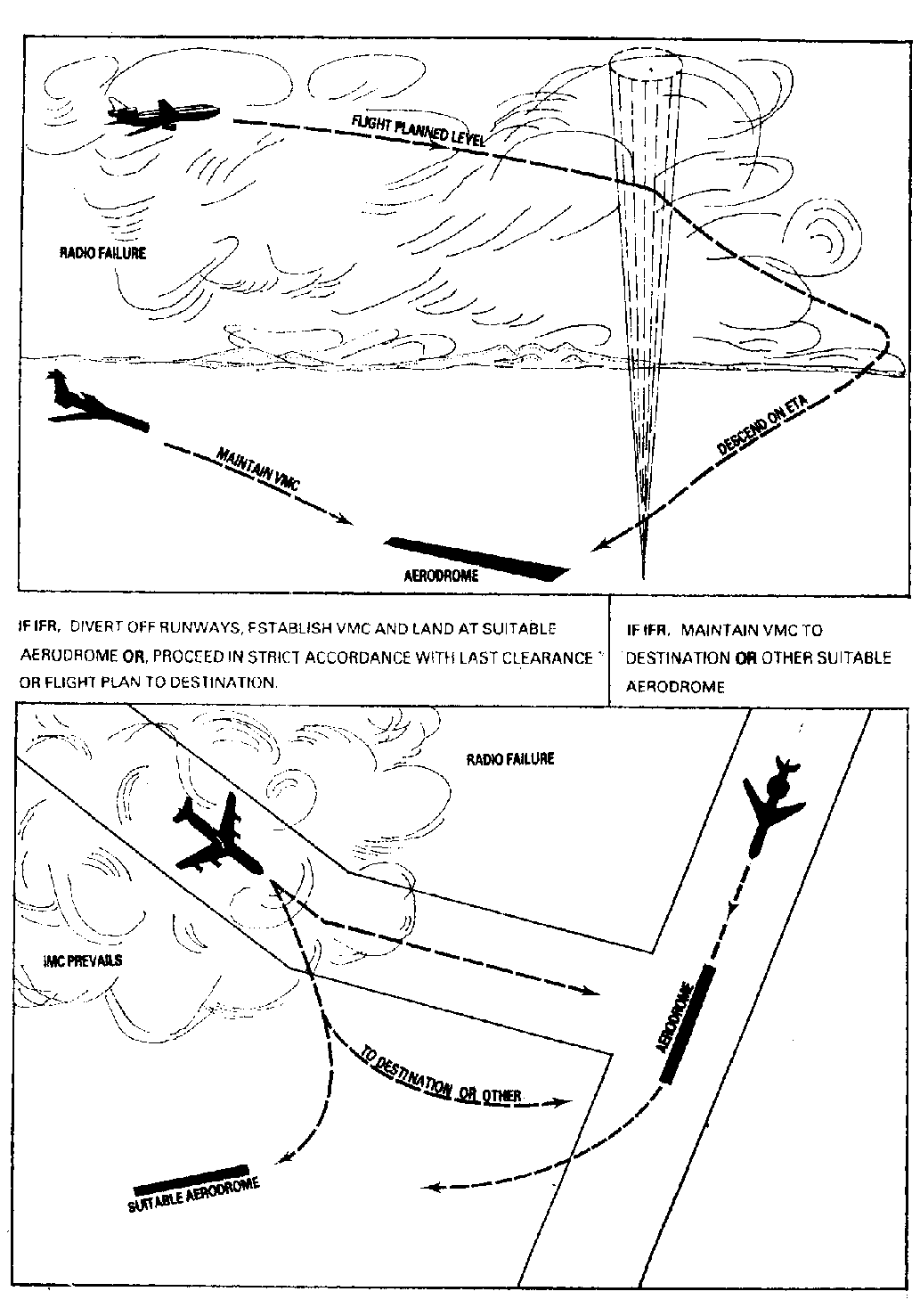
1.6.1.8.1 Aircraft declaring an emergency shall do so on the frequency to which they are communicating with ATC. Depending on the nature of the emergency, ATC may suggest a change of frequency.
1.6.1.8.2 All possible assistance will be given to aircraft in emergency regardless of the services being provided at the time of declaration of the emergency.

1.6.2  Radio Failure

1.6.2.1  General Rules - Pilot Procedure
1.6.2.1.1 In the event of failure of any part of his communication equipment in controlled airspace, the pilot-in-command shall notify ATC.
1.6.2.1.2 If a pilot fails to establish or maintain communication on a designated frequency and has been given “delay not determined”, he should not land at the destination aerodrome but proceed to the nominated alternate aerodrome.
1.6.2.1.3 If total radio communication failure occurs in VMC during daylight hours (HJ), the pilot-in-command shall:
  1. maintain flight in visual meteorological conditions;

  2. land at the nearest suitable aerodrome, which may be the destination aerodrome; and

  3. report his arrival to ATC by the quickest means.

1.6.2.1.4 If in instrument meteorological conditions or when conditions are such that it does not appear feasible to complete the flight in accordance with 2.1.3 the aircraft shall:
  1. unless otherwise prescribed on the basis of regional air navigation agreement, maintain the last assigned speed and level, or minimum flight altitude if higher, for a period of 20 minutes following the aircraft’s failure to report its position over a compulsory reporting point and thereafter adjust level and speed in accordance with the filed flight plan;

  2. proceed according to the current flight plan route to the appropriate designated navigation aid serving the destination aerodrome and, when required to ensure compliance with c) below, hold over this aid until commencement of descent;

  3. commence descent from the navigation aid specified in b) at, or as close as possible to, the expected approach time last received and acknowledged; or, if no expected approach time has been received and acknowledged, at, or as close as possible to, the estimated time of arrival resulting from the current flight plan;

  4. complete a normal instrument approach procedure as specified for the designated navigation aid; and

Note: land, if possible, within thirty minutes after the estimated time of arrival specified in c) or the last acknowledged expected approach time, whichever is later.

Note: During this 30 minutes period, ATC will reserve the airspace at the aircraft last assigned level. At the expiry of this period, and with the concurrence of the other user, normal operation will be resumed.

1.6.2.1.5 In all cases the pilot shall contact ATC as soon as possible after landing.
1.6.2.1.6 When a pilot fails to establish or maintain communication on a designated frequency, he shall attempt to communicate with other ATS units or aircraft on another frequency or frequencies appropriate to the route. If the pilot suspects that his transmitter is operating he shall transmit his message including his intentions twice on the designated frequency(ies) preceded by the phrase “TRANSMITTING BLIND”. Additionally, he shall select the SSR Code A7600 on the transponder.
1.6.2.1.7 If the aircraft has suffered receiver failure, the pilot shall transmit position reports at scheduled times or positions on the frequency in use, preceded by the phrase “TRANSMITTING BLIND DUE RECEIVER FAILURE”. The pilot shall repeat his message and shall also advise of the time of his next intended transmission.
1.6.2.2  General Rules - ATC Procedure
1.6.2.2.1 ATC will separate the aircraft experiencing radio communication failure from other aircraft based on the assumption that the pilot will follow the standard radio failure procedure stated in 2.1 unless it is determined that:
  1. based on information from electronic or other aids, a different action can be taken without impairing safety; or

  2. the aircraft is not following the standard procedures; or

  3. the aircraft has landed.

1.6.2.3  Communication Failure Whilst Under Surveillance Control
1.6.2.3.1 If two-way communication is lost with a surveillance-controlled aircraft, ATC will ascertain whether the aircraft’s receiver is working by transmitting on appropriate frequencies a request that the pilot-in-command acknowledges ATC transmissions by:
  1. squawking “ident”;

  2. changing SSR code;

  3. squawking “standby” for a specified period of time and then squawking an appropriate code; or

  4. executing a specified turn.

1.6.2.3.2 If communication is established by the above manner, the pilot-in-command will be requested to acknowledge clearances or instructions or to respond to questions by using the transponder or by executing specified turns.
1.6.2.3.3 If communication is lost with an aircraft being vectored, the pilot-in-command shall maintain the last assigned heading and altitude for 1 minute. In IMC, if the assigned altitude is below the Minimum Safe Altitude, the pilot shall climb to the Minimum Safe Altitude and proceed by the most direct path to the holding point associated with the runway in use and carry out the standard radio failure procedure.
1.6.2.4  Communications Failure Experienced By Departed Aircraft
1.6.2.4.1 The pilot-in-command of a departed IFR flight in IMC, who has acknowledged a climb to an initial level other than the flight planned level for the en-route phase of the flight and experiencing two-way radio communication failure after departure, shall proceed to his destination as follows:
  1. set the SSR transponder to code 7600;

  2. maintain the last assigned level for a period of 3 minutes if no clearance time or geographical limit was given by ATC; and

  3. subsequently climb, complying with any level requirements stipulated in the SID or departure clearance as appropriate then to the cruising level in accordance with the current flight plan.

1.6.2.4.2 If during the 3-minute period specified in 2.4.1 b) the pilot will encounter a minimum IFR level that exceeds the level last assigned by ATC then the pilot shall climb to the minimum IFR level.
1.6.2.4.3 The pilot-in-command of an aircraft that is being radar vectored after departure and experiencing communications failure shall:
  1. set the transponder to 7600;

  2. maintain the last assigned altitude and heading for a period of 2 minutes and if the assigned altitude is lower than the Minimum Safe Altitude, climb to the Minimum Safe Altitude; an

  3. proceed by the most direct path to intercept the current flight planned route climbing to the flight planned level to the destination.

1.6.2.4.4 If circumstances do not permit the flight to proceed to the destination, the pilot-in-command shall maintain VMC and avoid known areas of dense traffic and land at the most suitable aerodrome, which may be the departure aerodrome.
1.6.2.5  Special Procedures in the Kuala Lumpur TMA
1.6.2.5.1 The following special procedures shall apply to aircraft proceeding to the KL International / Sepang or the Subang/Sultan Abdul Aziz Shah.
1.6.2.5.2 Pilots assigned or already established on a STAR for KL International / Sepang or Subang/Sultan Abdul Aziz Shah shall comply with procedures given in the respective instrument charts.
1.6.2.6   KL International / Sepang
1.6.2.6.1  If total radio communication failure occurs to an aircraft bound for the Kuala Lumpur International Airport, before being given and acknowledged a specific STAR, the pilot-in-command shall:
  1. Squawk 7600;

  2. Transmit blind position report and state intentions, if the aircraft’s transmitter is presumed to be serviceable;

  3. Maintain the last assigned ALT or FL and proceed via airways, thereafter the appropriate STAR (PUGER 1G, KAKAK 1G, SAROX 1G, NIREN 1G, GUPTA 1G, SALAX 1G) for RWY 32R to EGURI Holding Area (right turn, inbound track 224°);

  4. Commence descend over EGURI Holding Area, at or as close as possible to the ETA indicated in FPL;

  5. Carry out ILS APCH/GNSS APCH for RWY 32R;

  6. Land on RWY 32R, if possible within 30 minutes of the ETA calculated in c), or the last ETA acknowledged whichever is the later;

  7. If landing on RWY 32R is not possible due to aerodrome wind conditions, the pilot-in command shall:

    1. In VMC, go around, join Left hand downwind RWY14L for a visual approach RWY 14L; or

    2. In IMC, at missed approach point (MAPt) RWY 32R carry out missed approach, proceed on Track 326°, climb and maintain 7000ft. At 4 DME VKL or on passing 4000ft, turn Right to KK895. Carry out ILS APCH/GNSS APCH for RWY 14L.

  8. In the event Runway 1 (RWY 14L/32R) is not available, ATC will switch the runway and approach lights on and off repeatedly to warn the pilot-in-command. The pilot-in-command shall:

    1. In VMC, go around, join right hand downwind for a visual approach RWY 32L; or

    2. In IMC, at missed approach point (MAPt) RWY 32R carry out missed approach, proceed on Track 326°, climb and maintain 7000ft. At 4 DME VKL or passing 4000ft, turn right to KK893. Carry out ILS APCH/GNSS APCH for RWY 32L.

1.6.2.6.2  In the event of total radio communications failure, pilots shall endeavour to establish communication with ATC by any alternative means, Eg: CPDLC or SATCOM.
1.6.2.6.3  If total radio communication failure occurs to an aircraft bound for the KL International Airport, Sepang, after having been given and acknowledged a specific STAR, the pilot-in-command shall follow the STAR and land on the assigned RWY
1.6.2.7   Subang/Sultan Abdul Aziz Shah
1.6.2.7.1 If total radio communication failure occurs to an aircraft bound for the Subang/Sultan Abdul Aziz Shah, before entering the Kuala Lumpur FIR or after entering the FIR but before being given or acknowledging a specific STAR, the pilot-in-command shall:
  1. In VMC, during daylight hours, maintain VFR and land at Subang/Sultan Abdul Aziz Shah or at a suitable aerodrome. Pilots shall take note that the KL International / Sepang is not to be considered as a suitable aerodrome for this purpose;

  2. In IMC or between the hours of sunset and sunrise, proceed via flight plan route or as cleared by ATC at last assigned level:

    1. If route terminates at VKL, then from VKL proceed to VBA maintaining the last assigned flight level;

    2. If the route terminates at VBA, then proceed to step d).

  3. Transmit blind position reports and intentions if the aircraft’s transmitter is presumed serviceable;

  4. Commence descent in the VBA hold at, or as close as possible to, the EAT last received and acknowledged or, if no EAT has been received and acknowledged, at or as close as possible to the ETA calculated from the current flight plan;

  5. Carry out and instrument approach procedure for Subang RWY 15;

  6. Land on RWY 15, if possible, within 30 minutes of the ETA calculated in d), or the last ETA acknowledged whichever is the later;

  7. If a landing on RWY 15 is not possible due to aerodrome wind conditions make a missed approach:

    1. if visual, from the missed approach make a visual approach to join left downwind for RWY 33;

    2. if in IMC, carry out standard missed approach procedure climbing 4000 feet track to ABTOM and hold.

1.6.2.8  Special Procedure - Johor Bahru
1.6.2.8.1  If Radio Communication Failure Johor Approach shall adapt to the following procedures if experiencing problem with the VHF radio at CWP. If main or standby radio frequency 124.7 MHz is unserviceable, ATC may use:
  1. Secondary frequency 121.05 MHz; or

  2. Johor Tower frequency 118.15 MHz after consultation with ATCC Watch Supervisor and coordination with Johor Tower Supervisor and Johor Tower may use Johor Ground Frequency 121.8 MHz as Johor Tower operation as for temporary measure; or

  3. Request assistant from Sector 2 or Johor Tower.

1.6.2.8.1.1 Squawk 7600. If under Pilot Navigation Continue on STAR and land.
1.6.2.8.1.2 If total radio communication failure occurs in VMC during daylight hours to an aircraft bound for Johor Bahru, the pilot shall maintain VFR and land at Johor Bahru or at a suitable aerodrome outside controlled airspace.
1.6.2.8.1.3 In IMC or between the hours of sunset and sunrise, an aircraft experiencing radio failure shall conduct its flight in accordance with the basic radio failure procedures.
1.6.2.8.1.4 In IMC or between the hours of sunset and sunrise, an aircraft experiencing radio failure before receiving clearance to enter the Johor Terminal Area shall proceed via Airways to the ’VJBVOR/DME.
1.6.2.8.1.5 Identification of the runway in use shall be made by reference to the CATIS, PAPI and/or Approach lights which shall be switched on for such an exigency.
1.6.2.8.2  Emergency Diversion Tracks
1.6.2.8.2.1 If an emergency descent is to be made by an aircraft holding in the’VJBVOR/DME holding stack, all aircraft holding below the level of the emergency aircraft, shall be instructed to divert immediately on a track of 306° (M) until the emergency aircraft has vacated each aircraft's level.
1.6.2.9  Radio Communication Failure Procedure For Kerteh
1.6.2.9.1 If total communication failure occurs in VMC during daylight hours, the pilot shall maintain VFR and join left hand downwind for Runway 34 or right hand downwind for RWY 16. Pilots should endeavour to keep clear of the eastern side of the airfield in order to avoid any confliction with helicopter operating to and from the oil rigs via the eastern corridor. Keep a look out for light or pyrotechnic signal from the tower.
1.6.2.9.2 In IMC or between the hours of sunset and sunrise, radio failure aircraft shall conduct its flight in accordance with the basic radio failure procedures as published in para 1.6.2.1.
1.6.2.9.3 In IMC or between the hours of sunset and sunrise, if radio failure occurs before clearance to enter Kerteh control airspace is given, maintain last cleared level direct to 'VKP' and make an instrument approach for RWY 34.
1.6.2.9.4 Identification for the runway in use shall be made by reference to lighted windsock and PAPI. Keep a look out for light and pyrotechnic signals.
1.6.2.9.5 Radio communication failure procedures for helicopters operating to and form the oil rigs in South China Sea.
  1. Should total radio communication failure occur in VMC during daylight hours, the pilot shall maintain VFR, not above 5500 ft (QNH), track via the eastern corridor, between oil refinery complex and Bukit Labohan for east of Kerteh airfield and join left hand downwind for RWY 16 or right hand downwind for RWY 34. Keep a look out for light and pyrotechnic signals from the tower.

  2. In IMC or between the hours of sunset and sunrise, follow procedures as in para 1.6.2.9.2 and 1.6.2.9.3 above.

1.6.2.10  TOTAL RADAR FAILURE - PROCEDURES TO BE ADOPTED BY ATC
1.6.2.10.1 In the event of total failure of the ATC radar system the following will be undertaken:
  1. ATC shall advise pilots-in-command of the radar failure via the appropriate air-ground channels.

  2. All departures may be suspended until aircraft in flight have been provided with standard separation based on a procedural control environment or have landed.

  3. As an emergency measure, the use of flight levels spaced by half the applicable vertical separation minimum may be resorted to temporarily if standard non-radar separation cannot be provided immediately.

  4. Inbound aircraft may be held en-route and clearance to leave the holding areas for an approach to land will be subject to the disposition of the preceding aircraft.

  5. Departing aircraft may be continued to be regulated according the FPL or SIDs with the appropriate ‘Slot Time’. To assist ATC in providing separation, pilots-in-command of aircraft departing on SIDs shall report established on the flight plan ATS routes as soon as possible.

  6. When radar services are re-established, ATC shall notify pilots via the air-ground channels and the ATIS. ATC will also take action to re-establish aircraft identification before providing radar services.

1.6.2.10.2 Pilots shall take note that extended delays to operations may result depending on the traffic and weather conditions. ATC will attempt to notify pilots of inbound aircraft of the extent of the delay to enable pilots to decide whether to hold or to divert without delay.
1.6.2.10.3 ATC shall transmit on the ATIS advising all pilots-in-command that “radar failure recovery procedures are in operation, all aircraft are to adhere strictly to ATC instructions.”
1.6.2.11  PROCEDURES TO BE ADOPTED IN THE EVENT OF FAILURE OF KUALA LUMPUR VOR/DME (VKL)
1.6.2.11.1 Runway operations at KLIA will be confined to either segregated operations or single runway operations only.
1.6.2.11.2 Aircraft with RNAV capabilities may still use SIDs and STARs. RNAV aircraft tracking on SIDs and STARs will be radar monitored by ATC and routed as follows:
  1. Inbound aircraft to KL International / Sepang or Subang/Sultan Abdul Aziz Shah may be cleared via the ATS routes and STARs;

  2. Outbound aircraft from KL International / Sepang or Subang/Sultan Abdul Aziz Shah may be cleared via SIDs to the ATS routes.

1.6.2.11.3 Aircraft, which do not have RNAV capabilities, will have their SIDs and STARs terminated and ATC will, as appropriate, clear aircraft as follows:
  1. Arriving aircraft

    1. Aircraft already assigned STARs will have their STARs cancelled, and will be radar vectored to final approach. Aircraft may be cleared to use KIKAL THREE Arrival and LAPIR THREE Arrival procedures.

    2. Aircraft not yet issued with a STAR will be radar vectored to final approach.

    3. Aircraft will be cleared by ATS routes. Pilots-in-command shall use available alternate radio navigation aids. ATC will provide radar surveillance and assistance to the pilot-in-command to maintain the correct track.

  2. Departing aircraft

    1. Aircraft already established on SIDs will be radar vectored to intercept the outbound ATS routes.

    2. Aircraft that have been issued with SIDs, but have not departed as yet will have their SIDs cancelled;

    3. Published Radar Departure procedure shall be used;

    4. In case of aircraft departing from a runway for which radar departures have not been published, it will be issued with radar departure instructions that will require:

      1. Pilots to maintain runway heading; and

      2. ATC to vector the aircraft to intercept the ATS route when the aircraft has climbed above the Minimum Safe Altitude shown on the Radar Vectoring Area Chart.

1.6.3  Secondary Surveillance Radar

1.6.3.1  SSR Code Allocation Procedures
1.6.3.1.1 All aircraft flying within controlled airspace in the Kuala Lumpur FIR and Kota Kinabalu FIR shall be equipped with SSR transponder complying with ICAO Standards and having both Mode 3/A 4096 and Mode C automatic pressure altitude reporting capabilities. They shall operate their SSR transponder on Mode 3A and Mode C simultaneously.
1.6.3.1.2 Special dispensation may be granted to aircraft without a serviceable transponder. This will be treated on an individual basis and subject to any conditions that may be imposed. Approval for such dispensation should be made through nearest ATCC unit. Such approval will depend on the traffic movements in the airspace concerned.
1.6.3.2  Emergency Codes
1.6.3.2.1 One of the following codes shall be set by pilots of aircraft experiencing the appropriate emergency situation:
  1. Emergency - Code 7700

  2. Radio Communication Failure - Code 7600

  3. Unlawful Interference - Code 7500

1.6.3.3  SSR Code Assignment
1.6.3.3.1 Discrete Mode A codes in the following blocks will be assigned on a routine basis to all flights from the following blocks:

Kuala Lumpur FIR:

  • International Departures: 2100 - 2177

  • 2600 - 2677

  • 5400 - 5477

  • Domestic Flights: 0300 - 0377

  • 3000 - 3077

  • 3400 - 3477

  • 4000 - 4077

  • 5100 - 5177

Kota Kinabalu FIR:

  • International Departures: 2001 - 2077

  • 0400 - 0477

  • Domestic Flights: 0500 - 0577

  • 3100 - 3177

  • 5200 - 5277

  • Brunei 7300 - 7377

1.6.3.3.2 Aircraft transitting the FIRs shall retain their assigned code. If a discrete code has not been assigned, pilots shall set transponders to A2000 and contact ATC as soon as possible for a discrete code assignment.
1.6.3.3.3 The codes 0577 and 0757 will not be assigned to aircraft as they are permanently assigned to the SSR site monitor (parrot) to check the accuracy of the system.
1.6.3.4  SSR Operations
1.6.3.4.1 The following procedures shall be adopted by all departures and arrivals:
1.6.3.4.1.1 Departing aircraft on first contact with Approach Radar unit shall report:
  1. Departure Clearance;

  2. Level Passing to the nearest 100 ft;

  3. Level Climbing To.

1.6.3.4.1.2 Arriving aircraft on first contact with Approach Radar unit shall report:
  1. Level Passing to the nearest 100 ft;

  2. Level Descending To.

1.6.4  Air Traffic Control Radar Units

LOCATIONCALL SIGNSERVICES PROVIDED
Peninsular Malaysia

Butterworth

(RMAF)

Butterworth Radar
  1. Control Service (Approach)

  2. Advisory Service

  3. Flight Information Service

  4. Weather Surveillance and Avoidance Service

  5. Final Approach Service (PAR)

Kuala Lumpur Air Traffic Control Centre

Lumpur Radar

  1. Control Service (Area / Approach)

  2. Advisory Service

  3. Flight Information Service

Kuantan

(RMAF)

Kuantan Approach
  1. Control Service (Approach)

  2. Advisory Service

  3. Flight Information Service

  4. Weather Surveillance and Avoidance Service

  5. Final Approach Service (SRA and PAR Runway 36 only)

Langkawi Langkawi APP
  1. Control Service (Approach)

  2. Advisory Service

  3. Flight Information Service

Kota Bharu Kota Bharu Approach
  1. Control Service (Approach)

  2. Advisory Service

  3. Flight Information Service

Johor Bahru Johor Approach
  1. Control Service (Approach)

  2. Advisory Service

  3. Flight Information Service

Sabah

Kota Kinabalu Air Traffic Control Centre

Kinabalu Radar

  1. Control Service (Area / Approach)

  2. Advisory Service

  3. Flight Information Service

Labuan

(RMAF)

Labuan Tower
  1. Control Service (Approach)

  2. Advisory Service

  3. Flight Information Service

  4. Weather Surveillance and Avoidance Service

  5. Final Approach Service (PAR Runway 32 only)

Tawau Tawau Approach
  1. Control Service (Approach)

  2. Advisory Service

  3. Flight Information Service

Sarawak

Kuching
Air Traffic Control Centre

Kuching Radar

  1. Control Service (Area / Approach)

  2. Advisory Service

  3. Flight Information Service

Sibu Sibu Radar
  1. Control Service (Approach)

  2. Advisory Service

  3. Flight Information Service

Miri

Miri Approach

  1. Control Service (Approach)

  2. Advisory Service

  3. Flight Information Service

Figure 110. RADAR COVERAGE CHART
PDF../graphics/7503.pdf
Figure 111. AIRCRAFT HOLDING POSITION
PDF../graphics/122645.pdf