1.5.1 General
1.5.1.1 The Standard Arrival Routes, Standard Departure Routes, Holding, Instrument Approach, Landing and Missed Approach in use throughout the
Kuala Lumpur FIRTAIRSPACE;TXT_NAME;1 and
Kota Kinabalu FIRTAIRSPACE;TXT_NAME;361 conform substantially with those contained in ICAO DOC 8168 - Procedures For Air Navigation Services - Aircraft Operations (PANS-OPS). Where differences exist they will be indicated on either the appropriate chart or in the Special Procedure section of the text.
1.5.1.1.1 To ensure conformity with associated procedures, this section should be read in conjunction with ENR 1.1.
1.5.1.1.2 An aircraft approaching an aerodrome under IFR for the purpose of making a landing, shall conform to the holding and instrument approach procedures for the radio navigation aid employed as prescribed in the appropriate AD charts. Where procedures have not been prescribed, airline operators will submit such approach procedures to the Chief Executive Officer of Civil Aviation Authority of Malaysia. Operators must accept full responsibility for such procedures and for the accuracy of any charts on which they are portrayed.
1.5.1.1.3 When an aircraft making an instrument approach by day establishes continuous visual reference with the ground or water above the minimum altitude, it may discontinue instrument approach. The pilot-in-command shall be solely responsible for ensuring obstacle clearance from the time visual flight is assumed. In all cases ATC approval shall be obtained.
1.5.1.1.4 In Instrument approach and landing charts, full lines are used to indicate Approach Procedures, broken lines to indicate Overshoot Procedures and thin lines to indicate Holding Pattern. Dotted lines indicate addition / alternate procedure tracks.
1.5.1.1.5 Pilots are expected to know the correct holding, approach and departure procedures (although ATC will provide this information on request).
1.5.1.1.6 The data shown in AD charts conforms to the following:
Bearings
Degrees magnetic
Distance Longitudinal
Nautical Miles and tenths
Distance Vertical
Feet (related to MSL except where the figures appear in parenthesis, e.g. (245) when the datum for measurement will be threshold elevation).
Rate of turn
Turns will be made at rate 1 (3 degrees per second) unless otherwise specified.
Bank angle not exceeding 25° for holding and Approach and 15° for Missed Approach.
Rate of descent
Not less than 500 FPM for Standard Instrument Approach Procedures.
1.5.1.1.7 Plans and procedure diagrams for holding and approach in AD charts are designed of the basis of the following values:
Tangible values
maximum true airspeed of 250 kts;
Minimum true airspeed of 90kts;
Wind speed up to 60 kt from any direction; and
Tolerances for ground and airborne equipment as prescribed in ICAO Annex 10.
Intangible values
Pilot Proficiency;
Width of ambiguity at heights above radio navigational aids;
Effects of turbulence and;
Corrections by pilot for wind effect.
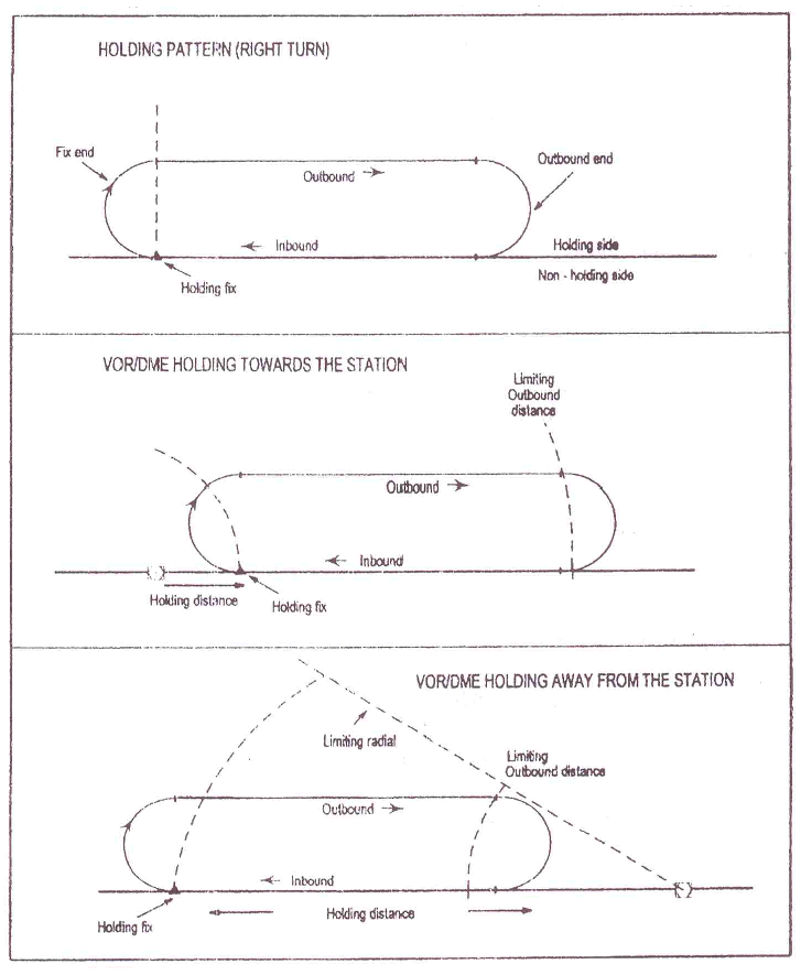
1.5.1.2 Holding Procedure
1.5.1.2.1 Initial approach tracks and holding patterns are detailed in AD on specific approach charts prepared for the purpose.
1.5.1.2.2 Holding patterns are ’race-track’ in shape and the terminology associated with their use is as shown in Figure 1.
In this case Sector 1 and Sector 2 entries are not authorised. The holding pattern will be entered directly along the entry radial or by the Sector 3 entry procedure. Having reached the secondary fix, the aircraft will turn right and follow the holding pattern. The entry radial is published and clearly depicted. For the left hand holding pattern the ’mirrored reflection’ of this case will apply.
Figure 1. Shape and terminology associated with right turns holding pattern.
1.5.1.2.3 The time or distance outbound is that measured from abeam the fix point to the commencement of the 180° turn (1 Min up to FL 140 and 1 1/2 Min above FL140).
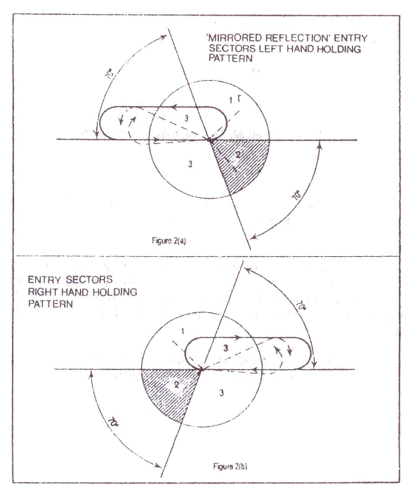
1.5.1.2.4 Except where specified procedures to the contrary are prescribed on particular charts in AD, or in Company Operations Manuals, aircraft entering a holding pattern shall manoeuvre appropriate to their sector of initial approach to the facility in accordance with the Holding Pattern Entry procedures in para 1.5.1.3.
1.5.1.3 Holding Pattern Entry Procedures
1.5.1.3.1 The three entry sector Holding Pattern Procedures and the ’mirrored reflection’ of the entry procedure are described below for holding on VOR intersections or VOR/DME fixes entries and limited to the radials and DME arcs.
1.5.1.3.1.1 Sector (1) Procedure (parallel entry)
Having reached the fix, turn onto an outbound heading for the appropriate period of time or distance then
Turn left or right on to the holding side as appropriate to intercept the inbound track or to return to the fix, and then
On second arrival over the fix, turn right or left as appropriate and follow the holding pattern.
1.5.1.3.1.2 Sector (2) Procedure (offset entry)
Having reached the fix, turn onto a heading to make good a track making an angle of 30° or less from the reciprocal of the inbound track on the holding side, then
Fly outbound for the appropriate period of time or distance as specified or
Where a limited radial is also specified, either until the radial is encountered or until the appropriate DME distance is attained, whichever occurs first, then
Turn right or left as appropriate to intercept the inbound track and follow the holding pattern.
1.5.1.3.1.3 Sector (3) Procedure (direct entry)
Having reached the fix, turn right or left as appropriate and follow the holding pattern.
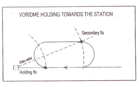
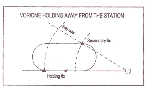
1.5.1.3.2 Special VOR/DME holding entry procedure
1.5.1.3.2.1 For entry into a VOR/DME holding pattern an entry radial to a secondary fix at the end of the outbound leg is established (See Figure 3(a) and 3(b). In this case Sector 1 and Sector 2 entries are not authorised. The holding pattern will be entered directly along the entry radial or by the Sector 3 entry procedure. Having reached the secondary fix, the aircraft will turn right and follow the holding pattern. The entry radial is published and clearly depicted. For the left hand holding pattern the ’mirrored reflection’ of this case will apply.
Figure 3 (a). Entry to a VOR/DME fix on the outbound leg - towards holding
Figure 3(b). Entry to VOR/DME fix on the outbound leg - holding away
1.5.1.3.3 Aircraft which enter holding patterns at altitude in excess of the altitude prescribed for the commencement of the instrument approach procedure may lose excess altitude by descending in the holding pattern. Descent may be continued during turns.
1.5.1.3.4 At controlled aerodromes, when an expected approach time (EAT) is specified, the pilot may shorten his holding in order to leave the holding fix at that time. If the EAT is such that prolonged holding is anticipated, the pilot-in-command may request that the length of the holding pattern be increased or may absorb time by other approved means. Where traffic permits, such requests will be granted subject to such conditions as may be specified due to prevailing conditions.
1.5.1.3.5 In uncontrolled airspace the pilot-in-command may increase the length of the holding pattern if he informs the FIC of his intentions and is able to ensure obstacle clearance to approved standards.
1.5.2 Arriving Flights
1.5.2.1 Continuous Descent Approach (CDA)
1.5.2.1.1 Pilots are encouraged to plan their descent in a manner that will permit a CDA into all airports in Malaysia. ATC will assist by providing timely descent clearances consistent with separation requirements to achieve CDA.
1.5.2.2 Standard Arrival Routes
1.5.2.2.1 A Standard Arrival Route (STARs) is a designated instrument flight rule (IFR) arrival route linking a significant point, normally on an ATS route, with a point from which a published instrument approach procedure can be commenced.
1.5.2.2.2 STARs are designed to:
reduce pilot and controller workload, including air-ground communications;
maximise traffic handling capacity;
minimise conflict with departing traffic; and
satisfy any noise abatement requirements.
1.5.2.2.3 STARs are presented in diagrammatic and textual format on a chart which comprises the following elements:
an ARRIVAL route; and, if necessary
a TRANSITION route.
1.5.2.2.4 Additional elements on the STAR chart include the following:
vertical restrictions, designed to contain aircraft in controlled airspace, to separate aircraft from obstacles and to avoid, to the degree possible, conflict with departing traffic.
speed restrictions, that may also be used for the aforesaid purposes, or recommended speeds that may be used to assist jets turning onto base or final. The latter will take the form (Jets<=180kts), meaning an indicated air speed of 180kts or less is recommended for jets to avoid overshooting a turn. Note that arriving aircraft are not restricted to 250kts below 10,000ft-speed restrictions except for arrivals into KL International / SepangTAD_HP;TXT_NAME;1 (refer to AD 2-WMKK-1-27 para 2.22.5.5.2 and 2.22.5.5.4)
Minimum sector altitude (MSA) within 25NM of the main tracking aid. The MSA provides a minimum of 1,000FT vertical clearance within 5NM of any obstacle.
Note: Tracking in the Kuala Lumpur terminal airspace may involve two VORs depicted on the same chart, in which case the MSA will be shown for both VORs.
1.5.2.2.5 STAR chart drawn to scale will display a scale bar or latitude/longitude grid. A scale bar may also be displayed on a chart that has tracks with break symbols, but only if there is no possibility of confusion between what is and what is not drawn to scale (a break symbol is used to depict a track that would otherwise extend beyond the boundaries of the chart at the scale being used). In other cases charts will be marked “NOT TO SCALE”.
1.5.2.2.6 Pilots-in-command shall comply with the procedure requirements defined in the STAR text description and also the mandatory procedure requirements defined in the STAR diagram.
1.5.2.2.7 Transition and arrival tracking
1.5.2.2.7.1 A TRANSITION starts at a fix on the ATS route, and then requires VOR, NDB or RNAV tracking to position an aircraft for the ARRIVAL route. An aircraft may also intercept a TRANSITION at an intermediate point after the start fix.
1.5.2.2.7.2 Aircraft may be radar vectored off the STAR for sequencing or other purposes. Such aircraft will subsequently be cleared to resume own navigation to a point along the STAR or to a point from which an instrument approach procedure can be commenced or radar vectored to intercept the final approach track. Whilst under radar vector, terrain clearance is the responsibility of ATC, but pilots are required to maintain an awareness of their situation in case of communications failure. Except when under radar vector, pilots shall adhere to all vertical restrictions shown diagrammatically on the STAR unless the restrictions are specifically cancelled. (read paras 1.5.2.2.8.5 and 1.5.2.2.9)
1.5.2.2.7.3 An ARRIVAL is applicable to one landing direction. The runway, therefore, need not be nominated except at multiple parallel runway airports.
1.5.2.2.7.4 Procedure design is based upon an aircraft using a Rate 1 turn or 25° angle of bank, whichever results in a lesser angle of bank, when turning onto base or final. Procedure design is also based upon aircraft using IAS 210kts for base turns and 180kts for final turns, taking into account omni-directional winds to 30kts. Notwithstanding the speeds used for procedure designs, pilots should use speeds applicable to their aircraft type and operating procedures, and make appropriate compensation for their aircraft speed and wind.
1.5.2.2.8 STAR clearance
1.5.2.2.8.1 STARs shall be issued by ATC in the following order:
ARRIVAL Identifier;
runway (for parallel runway operations only);
TRANSITION identifier;
Assigned level (if applicable).
Example:
"(C/S...) CLEARED VIA KAYELL ONE ARRIVAL SAROX TRANSITION (when ready {if applicable}) descend to seven thousand feet.
1.5.2.2.8.2 On being issued a STAR, a pilot is required to read back:
the ARRIVAL identifier;
specified runway;
a TRANSITION if it is followed by an alphabetical route identifier;
an assigned level.
1.5.2.2.8.3 A pilot shall request an alternative approach procedure if cleared via a STAR that requires the use of navigation aids not available on board the aircraft.
1.5.2.2.8.4 RNAV tracking requires the use of aircraft equipment having the capability of turn anticipation, so that fly-by way points are flown correctly. Pilots-in-command of aircraft not so equipped shall seek an alternative STAR or arrival instruction.
1.5.2.2.9 Vertical restrictions
1.5.2.2.9.1 Vertical restrictions are depicted on each TRANSITION and ARRIVAL.
1.5.2.2.10 STAR identification
1.5.2.2.10.1 An ARRIVAL is identified by the following items:
The name of the fix at the start of the ARRIVAL route;
A validity number to identify the current procedure;
the word ARRIVAL.
Example: NIPAR ONE ARRIVAL
1.5.2.2.10.2 For parallel runway operations, the left or right runway will be nominated.
Example: NIPAR FOUR ARRIVAL RUNWAY 32 RIGHT
1.5.2.2.10.3 A TRANSITION is identified by the following items:
The name of the fix at the start of the TRANSITION route;
An alphabetical identifier, but only when different routes start at the same fix;
The word TRANSITION.
Example: PULIP BRAVO TRANSITION (meaning that there are at least two TRANSITION routes starting from the PULIP fix)
1.5.2.2.10.4 Amendments to an ARRIVAL or a TRANSITION will result in the affected chart being issued with the next number in sequence. Any change on the NIPAR ARRIVAL chart, for example, would result in the chart being re-issued as NIPAR TWO ARRIVAL. After NINE, numbers start again at ONE.
Note: In some cases a particular ARRIVAL will be depicted on more than one chart. In this case, a change on one chart will require the re-issue of more than one chart.
1.5.2.3 Instrument Approach Procedures
1.5.2.3.1 The design of instrument approach and flight procedures under new PANS/OPS DOC 8168/611 is dictated by terrain surrounding an aerodrome, the types of operations contemplated, and types of aircraft to be accommodated, dependent upon availability of existing navigational facilities.
1.5.2.3.2 Normally, straight-in approaches in line with the runway will be specified. A straight-in approach is considered acceptable if the angle between the final approach track and the runway centre line is 30° or less. Where constraints cause the final approach track to fall outside the criteria for a straight-in approach, a visual circling approach will be specified.
1.5.2.3.3 An instrument approach procedure consists of the arrival, initial, intermediate, final and missed approach segments. Only those segments affected by local conditions will be included in a procedure. Track guidance will normally be provided for all phases of flight throughout all respective segments.
1.5.2.3.4 Optimum descent gradients are determined and these will only be exceeded when alternative means of satisfying obstacle clearance requirements are impracticable. The maximum descent gradient and missed approach climb will be standardised for all procedures whenever possible.
1.5.2.3.5 All procedure turns executed during the intermediate procedure will be level turns in the horizontal plane.
1.5.2.3.6 Missed approaches necessitating a turn provide sufficient distance straight ahead for the aircraft to clean-up, establish climb, changes in airspeed and configuration and to gain altitude clear of all obstacles before initiating the turning missed approach.
1.5.2.4 Aircraft Categorisation
1.5.2.4.1 Aircraft performance has a direct effect on the airspace and visibility needed to perform the various manoeuvres associated with the conduct of instrument approach procedures. The most significant performance factor is aircraft speed. Accordingly, the following five categories of typical aircraft have been established based on 1.3 times stall speed in the landing configuration at a maximum certificated landing mass, to provide a standardised basis for relating aircraft manoeuvrability to specific instrument approach procedures.
Category A - less than 91 kt IAS
Category B - 91 kt or more but less than 121 kt IAS
Category C - 121 kt or more but less than 141 kt IAS
Category D - 141 kt or more but less than 166 kt IAS
Category E - 166 kt or more but less than 211 kt IAS
1.5.2.5 Obstacle Clearance
From the operational point of view it is stressed that the obstacle clearance applied in the development of each instrument approach procedure is considered to be the minimum required for an acceptable level of safety for operations.
1.5.2.6 Obstacle Clearance Altitude / Height (OCA/H)
1.5.2.6.1 For each individual approach procedure an obstacle clearance altitude / height (OCA/H) is calculated and published on the instrument approach chart. In the case of precision approach and circling approach procedures an OCA/H is specified for each category of aircraft listed above. Obstacle clearance altitude / height (OCA/H) is
in a precision approach procedure the lowest altitude (OCA) or alternatively the lowest height above the elevation of the relevant runway threshold (OCH), at which a missed approach must be initiated to ensure compliance with the appropriate obstacle clearance criteria; or
in a non-precision approach procedure the lowest altitude (OCA) or alternatively the lowest height above aerodrome elevation or the elevation of the relevant runway threshold, if the threshold elevation is more than 7 ft below the aerodrome elevation (OCH), below which the aircraft cannot descend without infringing the appropriate obstacle clearance criteria; or
in a visual (circling) procedure, the lowest altitude (OCA) or alternatively the lowest height above the aerodrome elevation (OCH) below which an aircraft cannot descend without infringing the appropriate obstacle clearance criteria.
1.5.2.7 Factors Affecting Operational Minima
1.5.2.7.1 In general, minima are developed by adding the effect of a number or operational factors to OCA/H to produce, in the case of precision approaches, decision altitude (DA) or decision height (DH) and, in the case of non-precision approaches, minimum descent altitude (MDA) or minimum decision height (MDH).
1.5.2.8 Arrival Segment
1.5.2.8.1 Minimum Sector altitudes are established for all aerodromes where instrument approach procedures apply. Each minimum sector altitude provides terrain clearance of at least 1000 ft above the highest obstacle within 25 NM radius of the homing facility on which the instrument approach procedure is based. Where differences between sector altitudes are significant (i.e. in the order of 300 ft) a minimum altitude applicable to all sectors is published. A buffer area of 5 NM within the boundaries of sector altitudes is considered for obstacle clearance when establishing the minima for the sector concerned.
1.5.2.9 Initial Approach Segment
1.5.2.9.1 Straight-in tracks or DME arcs will be established to provide track guidance on to the intermediate track. These tracks will not exceed 120° angle of intersection between the initial approach track and the intermediate track. When the angle exceeds 70° a radial bearing or DME information providing at least 2 NM of lead will be identified to assist in leading the turn on to the intermediate or final approach track. Optimum descent gradients established for the initial approach will not exceed 4.0%. Where higher descent gradients are necessary to avoid obstacle, the maximum will not exceed 8.0%.
1.5.2.10 Types Of Manoeuvres
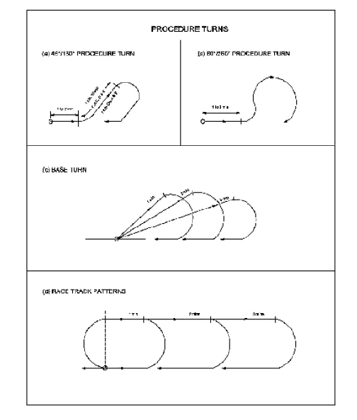
1.5.2.10.1 Reversal Procedure:
This will normally be procedure turn or a base turn. The following generally recognised manoeuvres rated to the reversal procedure will apply:
Procedure turn (45°/180°) consisting of a timed outbound flight from the facility or fix, a 45° turn away from the outbound track for 1 minute from the start of turn for Categories A and B and 1 minute 15 seconds from the start of turn for Categories C, D and E aircraft, followed by a 180° turn in the opposite direction to intercept the inbound track (see Figure 4 (a).
Procedure turn (80°/260°) consisting of a timed outbound flight from the facility or fix, an 80° turn away from the outbound track, followed by a turn in the opposite direction to intercept the inbound track (see Figure 4 (b).
Base turn consisting of a specified outbound track and timing from the facility followed by a turn to intercept the inbound track (see Figure 4 (c). The divergence angle between the outbound and inbound track is calculated as follows:
For TAS less than 170 kts, Ø = 36°/t where t is the time in minutes specified for the outbound leg.
For TAS exceeding 170 kts, Ø = (0.215 x TAS)/t, where t is the time in minutes specified for the outbound leg.
1.5.2.10.2 Racetrack Procedure:
A racetrack procedure consists of a turn from the inbound track through 180° from overhead the facility or fix on to the outbound track for 1, 2 or 3 minutes, followed by a 180° turn to return to the inbound track (see Figure 4 (d). The outbound leg will normally be limited by a fix where DME information is available. Aircraft are expected to enter the procedure in a manner comparable to that prescribed for holding procedure entry except that:
-
Offset entry from sector 2 shall limit the time on the 30° offset track to 1 minute 30 seconds after which the pilot is expected to turn to a heading parallel to the outbound track for the remainder of the outbound time. If the time outbound is only 1 minute, the time on the 30° offset track shall be 1 minute also.
-
parallel entry shall not return directly to the facility without first intercepting the inbound track (when proceeding onto the final approach segment).
-
All manoeuvring shall be done in so far as possible on the manoeuvring side of the inbound track.
Figure 4. Types of Reversal & Racetrack Procedures
1.5.2.10.3 A shuttle is prescribed in a standard holding pattern so that all turns after initial entry are made to the right, except where a 'non-standard' left turn pattern will provide a significant operational advantage. A shuttle will normally be prescribed where the descent required between the end of initial approach and the beginning of final approach exceeds the maximum specified descent values.
Note: A shuttle is descent or climb conducted in a holding pattern.
1.5.2.10.4 Descent gradient
Because the actual length of the track will vary, it is not practical to specify a descent gradient for the procedure turn or base turn. Instead the descent gradient will be controlled by requiring that the descent be achieved during the outbound and inbound track. The descent will not exceed the maximum specified values. Where these criteria cannot be met, only circling minima are authorised.
1.5.2.11 Intermediate Approach Segment
1.5.2.11.1 This is the segment during which the aircraft speed and configuration is adjusted to prepare the aircraft for final approach. For this reason the descent gradient is kept as shallow as possible. Where DME information is available, precise determination or manoeuvres will be established to provide guidance on to the final approach track.
1.5.2.11.2 Separate procedures are published for Categories A and B aircraft and for Categories C and D aircraft based on TAS 140 kts (A & B) and TAS 250 kts (C & D) respectively.
1.5.2.12 Final Approach Segment
1.5.2.12.1 Final Approach will be made to a runway for a straight- in landing or to an aerodrome for a visual manoeuvre.
1.5.2.12.2 Non Precision Approach
1.5.2.12.2.1 A final approach fix (FAF) is established for non- precision approaches at aerodromes where such a facility or DME information is designed to permit commencement of the final approach descent to obstacle clearance altitude / height (OCA/H) for instrument approach, or for a visual circling approach.
1.5.2.12.2.2 The FAF will normally be determined between 5 NM and 10 NM.
1.5.2.12.2.3 Where a step-down fix is incorporated in a non- precision approach procedure, two OCA/H values will be published a higher value applicable to the primary procedure, and a lower value applicable only, if the step-down fix is positively identified during the approach. Where DME fixes are available several minimum crossing altitudes will be depicted along the final descent track.
1.5.2.12.2.4 Where at aerodromes served by a single facility located on or near the aerodrome, and no other facility is suitably situated to form a FAF, the procedure is designed where the facility is both the intermediate fix (IF) and the missed approach point (MAPt).
1.5.2.12.2.5 Non-precision approaches designed for aerodromes with no final approach fix (FAF) will indicate a minimum altitude / height for a reversal or race track procedure and an OCA/H for a final approach. Descent to final approach OCA/H is commenced once the aircraft is established inbound on the final approach track.
1.5.2.12.3 Precision Approach - ILS
1.5.2.12.3.1 Final Approach descent is commenced at the final approach point (FAP) on the centre of the localizer where the intermediate approach altitude / height intersects the normal glide path, or final approach fix (FAF) when DME information is available.
1.5.2.12.3.2 Glide path interception published will normally take place between 1000 ft and 3000 ft above runway elevation designed for 3° GP intercept. This intercept point will be established between 3 NM and 10 NM from the runway threshold.
1.5.2.12.3.3 The width of the ILS approach area is much narrower than those of non-precision approaches. Descent on the glide path shall not be initiated until the aircraft is within the tracking tolerance of the localizer. The ILS obstacle clearance surfaces assume that the pilot does not normally deviate from the centre line more than half a scale deflection after being established on track. Thereafter the aircraft should adhere to the on-course, on-glide path position since a more than half course sector deflection or a more than half course fly-up deflection combined with other allowable system tolerances could place the aircraft in the vicinity of the edge or bottom of the protected airspace where loss of protection from obstacle can occur.
1.5.2.12.3.4 The intermediate approach track is designed to place the aircraft on the localizer at an altitude / height that is below the nominal glide path to assist in glide path interception.
1.5.2.12.3.5 The final approach area contains a fix or facility that permits verification of the glide path / altimeter relationship. The outer marker is normally used for this purpose. Prior to crossing the fix, descent may be made on the glide path to the published fix crossing altitude / height.
1.5.2.12.3.6 Descent below the fix crossing altitude / height should not be made prior to crossing the fix.
1.5.2.12.3.7 In the event of loss of glide path guidance during the approach, the procedure becomes a non-precision approach. The OCA/H published for the glide path in-operative case will then apply.
1.5.2.13 Final Approach Descent Gradient
1.5.2.13.1 The optimum descent gradient for final approach established will not exceed 5.2 percent (approximately 300 ft per nm which is equivalent to 3° glide path angle). This will be standardized and applicable to all aerodromes for both precision and non-precision approach procedures.
1.5.2.13.2 For precision and non-precision approach procedures at aerodromes with FAF or FAP determined, a 5.2 percent descent gradient corresponding to 3° glide path descent angle will be established. The designed final approach descent gradient will be published on all charts.
1.5.2.13.3 For non-precision approach procedures at aerodromes with no FAF (i.e. VOR, NDB procedures), a calculated position for final approach descent is determined (FAPn) in order to assist the pilot-in-command achieve the desired final approach descent gradient. The distance of this point from the runway threshold is published for pilots to establish the aircraft in the final approach configuration approximately at this distance, having regarded all other operational flying conditions so that the specified descent gradient and recommended descent rates for the aircraft category will not be exceeded. Pilots of aircraft with TAS that differ from the designed procedure of TAS 140 kts and TAS 225 kts should consider carefully the descent rates required for such non-precision final approach segments before starting the approach, as these rates will be higher than those published.
1.5.2.13.4 A descent gradient in excess of the optimum 5.2 percent will only be exceeded where alternate means of satisfying obstacle clearance requirements are impracticable. This will be published for the procedure concerned.
1.5.2.14 Missed Approach
1.5.2.14.1 The missed approach procedure specifies a point where the missed approach begins and a point or an altitude / height where it ends. The missed approach point (MAPt) in a procedure may be:
the point of intersection of an electronic glide path with the applicable OCA/H;
a navigational facility;
a fix; or
a specified distance OCA/H from the final approach fix (FAF).
1.5.2.14.2 If upon reaching the MAPt, the required visual reference is not established, the procedure requires that a missed approach be initiated at once in order for protection from obstacle to be maintained.
1.5.2.14.3 It is expected that the pilot will fly the missed approach procedure as published. In the event a missed approach is initiated prior to arriving at the missed approach point, it is expected that the pilot will normally proceed to the missed approach point and then follow the missed approach procedure in order to remain within the protected airspace.
1.5.2.14.4 The missed approach climb gradient for all procedures is based on a 2.5 percent standard and this will not be published. When other than a 2.5 percent gradient is used, this will be indicated on the instrument approach chart and, in addition to the OCA/H for the specific gradient used, the OCA/H applicable to the normal gradient will also be shown.
1.5.2.14.5 The initial missed approach phase begins at the missed approach point (MAPt) and ends at the point where the climb is established. No turns are specified in this phase.
1.5.2.14.6 The intermediate missed approach phase is the phase within which the climb is continued, normally straight ahead to the minimum altitude / height at which a turn in excess of 15° can be made. The intermediate missed approach track may be changed by a maximum of 15° from that of the initial missed approach phase.
1.5.2.14.7 The final missed approach phase begins at the minimum prescribed altitude / height for turns or for acceleration, whichever is lower, and ends at the point, where a new approach, holding or a return to en-route flight is initiated. Turns are prescribed in this phase.
1.5.2.14.8 Turning Missed Approach
1.5.2.14.8.1 Turns in missed approach procedures are only prescribed where terrain or other factors make a turn necessary. Turns greater than 15° required in a missed approach procedure are prescribed when at least 300 ft of vertical clearance above obstacles have been ensured. The turning point (TP) is specified in one of the three ways:
at a designated facility or fix - the turn may be made upon arrival overhead the facility or fix;
at a designated altitude - the turn may be made upon reaching the designated altitude unless an additional fix or distance is specified to limit early turns; or
at a designated dead-reckoned (DR) position - the turn may be made at the DR position based on time or distance past the facility or fix.
1.5.2.14.9 Protected airspace for turns is based on the highest final approach speed for the category of aircraft operating there. Where operationally required to avoid obstacles ahead the IAS for 'Intermediate Missed Approach' will be limited and such annotation indicated on the chart. Where obstacles are located early in the missed approach procedure, the instrument approach chart will indicate an annotation to an early missed approach turn as soon as operationally practicable.
1.5.2.14.10 All flights personnel are expected to comply with such annotations on approach charts and execute the appropriate manoeuvres without undue delay.
1.5.2.14.11 All turning points are buffered by fix tolerance areas. Turns at a DR position will not be established further than 10 NM beyond the fix from which timing begins. As there are no fixes or track guidance associated with the DR turning point, accurate airspeed control and time keeping within the accepted tolerances are essential.
1.5.2.14.12 Whenever so required by certain types of aircraft operating at the aerodrome concerned an acceleration portion 6 NM in length will be identified in the missed approach final phase for the aircraft to accelerate in level flight after the initial climb. The height of this position is dependent on the obstacles in the missed approach area. The horizontal portion is followed by a climbing portion with a 1.0 percent gradient representing en-route climb until an altitude at which other prescribed obstacle clearances become effective. It should be noted that the procedure is based on the assumption that the aircraft will remain above the missed approach surface until reaching the height of the acceleration portion.
1.5.2.15 Visual Manoeuvring (Circling) In The Vicinity Of The Aerodrome
1.5.2.15.1 This is the visual phase of flight after completing an instrument approach, to bring an aircraft into position for landing on a runway which is not suitably located for a straight-in-approach.
1.5.2.15.2 The visual manoeuvring area for a circling approach is determined by drawing arcs centred on each runway threshold and joining these arcs with tangent lines. The radius of the arcs is related to:
aircraft category;
speed for each category of aircraft (viz; A,B,C and D);
wind speed: 25 kt throughout the turn; and
bank angle: 20° average or 3° per second, whichever requires less bank.
1.5.2.15.3 A particular sector where a prominent obstacle exists in the visual manoeuvring (circling) area but outside the final approach and missed approach area may be eliminated from consideration. When this option is exercised the published procedure prohibits circling within the total sector in which the obstacle exists. (See Figure 5).
1.5.2.15.4 An obstacle clearance altitude/height (OCA/H) is determined for each category of aircraft operating in the visual manoeuvring area and this is published on the related chart.